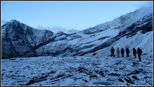
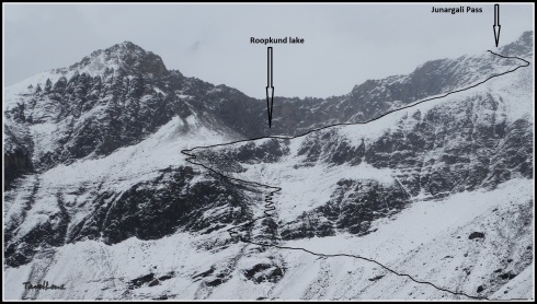
Somewhere between my last post on Sikkim and this one, many a thing happened. I lost a shoe in a Kudremukh monsoon trek – not to mention that I almost ‘drowned’ my phone too, found a friend in Cambodia, used a dry pit on the way to Roopkund, learnt to bargain in Thai in Ayuthayya, …… the list never ends.
I also got so caught up in the mundane grind of every day life. I’ve been off the grid lately, between trying to complete one assignment and starting another. My life has been preoccupied and I have discovered that the normal rhythm of my routine was thrown out of the kilter. Those rhythms revolved around my identity as a blogger. For these last couple of days, I was trying to be one. This is where I left off…
——————————————————————————————————————————–
There is a lake up there in the Sikkim Himalayas. It’s not easy to get there. Nor is it, mercifully, impossible. But content with the fact that this emerald, bluish-green or icy white droplet (depending on the month you visit it) of incredible beauty lies at 17,100 feet (5148 m) and over 16 hours and a night’s stay away from Gangtok makes for an unforgettable journey, not just the destination.

This lake could well be the focal point of your Sikkim trip…maybe, of even your Eastern Himalayas itinerary. Gurudongmar Lake is one of the highest lakes in the world. It lies on the northern side of the Khangchengyao range in a high plateau contiguous to the Tibetan plateau. A stream emerging from the lake is one of the source streams of the Teesta River – the life line of Sikkim. The Sikkimese believe that this lake has been blessed by Guru Padmasambhava – the founder of the Nyingma tradition, the oldest of the four major schools of Tibetan Buddhism. And it is he who lends his name to this sacred lake. The entire lake freezes in the winter with the exception of one small portion. When the ice melts in the summers, the waters are a clear, sparkling blue.

A visit to North Sikkim is the most popular circuit among visitors to Sikkim. The journey takes you from Gangtok through the hilly terrain of Mangan to Chungthang, a nodal junction. From here the road bifurcates for the Lachen and Lachung valleys. The road to Lachen takes you further up to Gurudongmar Lake, while the road to Lachung leads you to the Yumthang valley and further up to Zero point.

On a misty morning in April 2014, we left a rain drenched Gangtok and started our journey up on the winding roads that led to North Sikkim. Armed with a Mahindra Xylo and an enthusiastic driver, Farooq, we were on our way from the North Jeep stand in Gangtok.
We had decided on a 3 night/4 day package to Lachen and Lachung, which included a visit to Gurudongmar Lake, Yumthang Valley and Zero point. To go to North Sikkim, Indian citizens need a special Inner Line Permit from the Indian Army and Sikkim Police Authorities. This entire region is under the control of the Indian army and you need special restricted area permit to visit this lake. One can get a permit from the tourist information centre which is situated at MG road in Gangtok. Permits can also be easily arranged by most of the local travel agencies. We had decided to go with a travel agency which we had booked through the hotel we had stayed at – Hotel Sagorika. Foreign nationals are not permitted to visit the lake due to security reasons.

The drive was slow. The roads were bad. There were remnants of landslides, every now and then – small, large and sometimes massive. Sikkim is an earthquake prone zone. Here the mountainsides are brittle, leading to frequent mudslides, sliding rocks and boulders breaking loose. The earthquake in September 2011 was devastating and the National Highway 31A was badly hit. The landslides get timely cleared by the diligent Border Roads Organization (BRO). Or could we have travelled this far?

Apart from this distraction, the roads were quiet. There were no blaring horns. But on this stretch, honking could even trigger a landslide. And why honk at all? There were hardly any other vehicles on the road. We were also witnessing a sea of colors – colors which were very different from those on the omnipresent prayer flags fluttering in the wind. The political battle in Sikkim had intensified to a war footing with assembly elections in the state just a few days away. Flags from both the parties – the veteran player Sikkim Democratic Front (SDF) and the one year old Sikkim Krantikari Morcha (SKM) – dominated the road sides. SDF has been in power for an uninterrupted 20 years.

There was an unprecedented fervour and enthusiasm in the air….and the candidates kept smiling from posters and hoardings all along the way. We came across a few political gatherings at some of the towns we passed. It was the last few days of campaigning and the candidates were making the most of their last chances. We made a stop at Kabi Langchuk, 17 km from Gangtok, on the North Sikkim highway. This is the place where the historic treaty of blood brotherhood between the Lepcha and the Bhutia community chiefs took place. The spot where the ceremony took place is marked by a memorial stone pillar. Decorated with prayer flags and found amidst the cover of dense forest, this place is worth a visit.

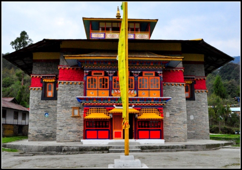
The entire route was extremely picturesque and green. A lot of waterfalls dotted the hills and we stopped at one of the famous places to admire the Seven Sisters Waterfalls. In terms of ‘Sikkim Tourism’, one of the most standout features in Sikkim is the vast number of beautiful monasteries. Most of the monasteries are high up in the mountains and are adorned with some really bright and colorful paintings. We did not want to miss out on the rich cultural, heritage and religious traditions of Sikkim. Phodong Monastery is one of the six major monasteries in Sikkim and was located on our way. We had travelled around 35 km from Gangtok on the highway, when Farooq took a sharp right turn and started climbing a small hill.
Labrang Monastery
We passed the Phodong Monastery first to first visit the Labrang Monastery, which was located further up. At Labrang, Buddhist prayer flags fluttered serenely in the mountain breeze. A few younger monks sat talking animatedly on the lawns. The monastery was small and stone-walled. The monotony of the grey stones were broken by the bright colours used on the prayer wheels and window frames. It looked ancient and it was… built in 1884. We walked towards the huge doors only to find it closed. Seeing us standing there knowing not what to do, two young monks came running to us. They had the key to the monastery. This is what happens in Sikkim. Monks are happy to receive visitors and to show them around.

Around Labrang Monastery
We entered the dimly lit prayer hall. The monks explained to us the various idols of Bodhisatvas that were arranged in the prayer hall. Colourful Thangkas and murals adorned the walls. There were wooden racks holding ancient manuscripts. We walked around taking in the mystical smell of ghee and incense.The monks also showed us to an upstairs room which had a green deity sporting a necklace of severed heads – Taradevi – a tantric manifestation of Durga.

Inside the Labrang Monastery
Thanking the monks we proceeded to the Phodong monastery. This was a bigger monastery and was bustling with senior monks in deep red robes walking around clutching to their ubiquitous prayer beads. Here, again, the prayer room was closed.

Phodong monastery
Our next stop was Mangan, the district headquarters of North Sikkim. In Mangan we showed our passport and finished other formalities. We were now driving along roads that were hacked out from the fragile mountains.At some places the roads looked like partially closed tunnels with protruding ledges overhanging. The ledges looked as if they would crumble at any moment.

We were now headed for Chungthang. This is one of the main towns in North Sikkim and is situated at the confluence of Lachen Chu and Lachung Chu. ‘Chu’ means river in Tibetan. The Lachen Chu and Lachung Chu together form the Teesta River.
Chungthang is located at a distance of 95 kilometers from Gangtok, at an elevation of 1,700 meters (5,600 ft). Chungthang is a major sub division in North Sikkim, and a nodal junction. Here we saw an ongoing work of a hydroelectric project.

From Chumthang, Lachen is about 27 km and Lachung is about 20 km. From Chumthang there was no tarmac on parts of the road and sometimes the jeep had to wade through streams that ran right through the road. As we moved further, the hills seemed to get taller and the valleys deeper.

We reached Lachen by 7 pm. Stepping down from the car we felt the chill. Lachen is built on a series of hills. It was necessary for us to stop for a night at Lachen to acclimatize before starting on our journey up. Accommodation was at Hotel View Point Lachen. The hotel was clean and comfortable and the food was simple but tasty.

Waking up the next morning, we were simply spellbound by the sublime beauty of the Lachen valley. Lachen, at 2750 m (9500 ft), is a small settlement. The village has a few houses, a lot of them converted into homestays, and a few lodges, all catering to the crowds visiting Gurudongmar Lake. There were barren mountains around with snowy peaks peeping higher behind them. Other than the houses and lodges there is a Gompa, the Lachen Gompa, where the footprints, a water-carrying utensil and a robe of Guru Padmasambhava are preserved. Over the years Lachen has transformed from a sleepy town to a bustling tourist destination.

Lachen at dawn
It was only 5.00 A.M and we were ready to set out for Gurudongmar Lake. Yes, the journey from Lachen to Gurudongmar starts very early in the morning. Driving through the larch and spruce forests of the upper Lachen Valley we could witness the most dramatic transformation of landscape. The trees were tall, may be centuries old. There were green meadows carpeted in wildflowers that ran for miles. There were rhododendron bushes as well, all waiting to bloom. During the months of May and June, the whole of Sikkim is transformed into a flush of myriad hues. We were a bit early. In April, the Rhododendrons were still in the buds. As we ascended higher, the terrain started getting bleaker and browner. We were leaving the greenery behind.

With each passing bend, we gradually gained altitude – the road got worse, and the climate got colder. We were driving along the right bank of Teesta River. Teesta had been our constant companion, sometimes running alongside and at other times a shimmering ribbon in a gorge deep below, rushing the through the rocks and boulders on its way down in the valley.

The further east we travelled the more the Teesta changed from a docile escort to a ferocious usher. The force with which it flows in these parts is the reason why there are so many hydroelectric projects on it. But, alas, these projects have taken away the charm of these places. The vegetation began to thin. Huge trees gave way to dwarf juniper and scrub jungles. Clouds hung heavy overhead and lay scattered all over the valley as the green cover gave way to sheer barrenness. In another two hours of steep ascent we would touch the Tibetan plateau.

We reached Thangu village by 7.00 am, two hours after we had left our cosy hotel in Lachen. Thangu, a small hamlet at 14000 ft, is the breakfast stop for all the travellers travelling to Gurudongmar. An ITBP camp is located here. Here, most of the houses double up as kitchen rooms where basic breakfast is served.
The last vestiges of sleep were dissolved by a piping hot bowl of spicy Maggi served with a few slices of buttered bread. It was warm inside the kitchen. There was a wooden pillar in the middle of the room which had a few coal ambers burning at its base. There were wooden planks arranged around the burning coal and we huddled around it savouring the hot Maggie. We also bought a few popcorn packets that were supposed to help combat altitude sickness.

We were rejuvenated to tackle the road again. The drive, the pace, the landscape, everything changed from here. The terrain now resembled a rocky wilderness. There was a rustic beauty to this place. A brown setting with a few spots of snow visible in the distance.

Our next pit stop was at the army check-point at Giangong. Here we had to show our permits and ID cards for security reasons. This place has the “The world’s highest cafe at 15,000 feet”, managed by the army. The journey from Giagong to Gurudongmar passes through one of the highest cold deserts in the world.

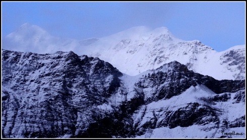
The craggy mountains stand out against the frozen streams and dusty roads. There were yaks grazing in the distance. The lake was another two hour drive from Giangong.

We were now driving into the treacherous Tibetan Plateau. Treacherous? We did spot a few army bunkers which were well camouflaged.

We also saw a few fenced mine areas. Army trucks and jeeps kept scuttling around. We were not very far from the border. But what scared us most were a few boards that had “This road is being watched by China. Do not stray” on it. With no clear roads it was easy to stray indeed; and any deviation from the roads would have led us to China!

The lake is just 5 km away from the border. Due to its proximity to China border, this area is very sensitive. This entire region is under control of Indian army.…… India truly feels far away.

We were driving on non-existent roads, so broken down that it would be illegal to call them roads. Farooq must have been channelizing his experience and his driver’s intuition to drive ahead.

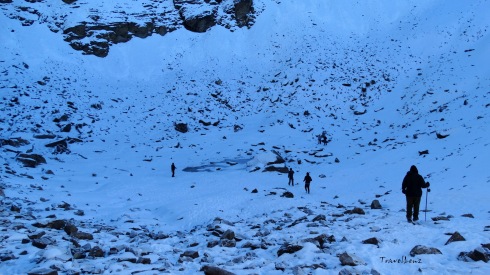
Suddenly the surreal movie depicting the mountain scenery of the trans-Himalayan path came to an end. Our bone-jarring ride had come to an end. We tumbled out from the Xylo, ready to pass out from the lack of oxygen. Even if we had fainted, the reward of this glorious view of the lake would have woken us up instantly. In front of us was the most awe-inspiring sight.

Gurudongmar Lake
It is very difficult to imagine a lake of this size situated in the middle of a cold desert. It took us a few moments to register the beauty of the place. Right in the middle of the alpine snow flanks was a lake covered with a thick layer of ice. And as the legend said a small portion did remain without ice.

Gurudongmar lake is said to be fed by melting glaciers. The lake is surrounded by the peaks of Chomiomo (6829 metres) and Kangchung Tso (6750 metres). Due to the sheer height of these mountains, the monsoon clouds cannot cross and get trapped on the mountain as snow. It never rains here, it seems. We were quite relieved to be not stacked amongst hordes of tourists. We were standing at one of high points of the globe. Colourful prayer flags were fluttering in the breeze. We walked towards a flight of stone steps and slowly climbed down. Standing by the lake, listening to the howl of the wind and the crackling of the ice on water, it was hard to describe what all this felt like. As the ice glistened and the water sparkled, it didn’t take long for us to fall under the spell.

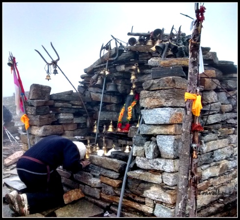
Totally bewitched at 17000 ft. The sun was getting brighter. It is mandatory to wear sun glasses under such conditions. You could go blind from the reflection of the white snow. The wind began to blow hard and was cutting through our numerous layers of woollies. After a few snaps, we started to climb up. Due to the increase in altitude and very less oxygen, every step appeared to be a huge challenge.The thin oxygen supply can leave you wanting for more and more air all the time. It does curious things to your mind and brain. Time stops. Your heart slows down. Despite the acute discomfort and slight headache, there was a desire to stay on. We trudged towards the Sarva Dharma Sthal.

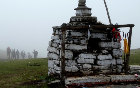
Sarva Dharma Sthal
The army maintains this tiny shrine that is found on the shore of the lake. For the past 1 hour we were finding it difficult to adjust to the cold weather and high altitude over here. The soldiers who patrol this area have to stay for a stretch of 20 days. We had to make it back to the army check-post before 12 pm, the deadline for visitors.

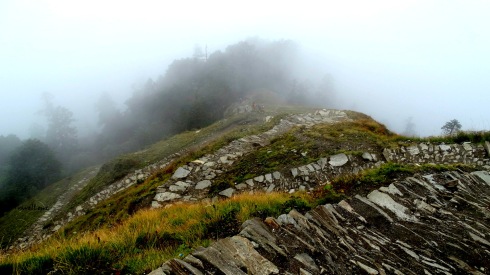
Chopta Valley
We began our descent. On our way back, we made a short stop at Chopta Valley. The rocky terrain gave way to a lush green wide expanse as we got to the top of the valley. Foreign nationals are only allowed till the Chopta valley.
Our journey back was uneventful. We reached back in Lachen by 3 pm. We did a quick visit to the Lachen Gompa, situated on top of a winding road.

Lachen Monastery
The Lachen town and its Gompa have been in news ever since Divya Khosla Kumar shot a a few scenes of her movie Yaariyan here.
Back at the hotel, we stood on the balcony looking out at the sleeping town and the swirling evening mist that was already eating into the hills behind it. Gurudongmar was somewhere in that whiteness but shining deep within us.

Sikkim has always been an enigma for me. There is so much hidden here, as much as is revealed. I ‘m not sure what I came searching for in Sikkim. Was it my quest for redemption, or my path to inspiration or maybe my test of spirituality….time will tell.
![Ed Viesturs [Photo Courtesy Pinterest, National Geographic]](https://travellenz.files.wordpress.com/2016/07/roopkundblogupload8.jpg?w=490&h=229)


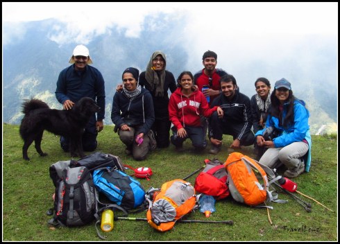
![The full team at Roopkund [Courtesy Shivam Singh]](https://travellenz.files.wordpress.com/2016/07/10676294_826593127362619_1289887569193449726_n.jpg?w=490&h=327)


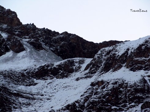


![Kalidak and Trishul [courtesy Ammu]](https://travellenz.files.wordpress.com/2016/04/dscn7115.jpg?w=490)
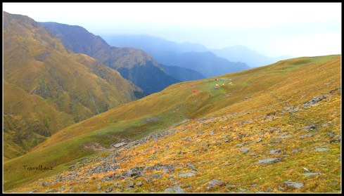
![Chaukhamba from Aki Bugyal [Courtesy Ammu]](https://travellenz.files.wordpress.com/2016/04/dscn7109.jpg?w=490)


![Bedni Kund [Courtesy Ani & Sabari]](https://travellenz.files.wordpress.com/2016/04/img_5349.jpg?w=490)


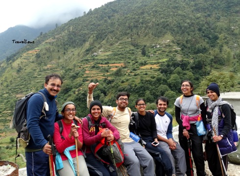
![Team @ Pathar Nachauni...and don't miss the pink gloves [courtesy Ani & Sabari]](https://travellenz.files.wordpress.com/2016/04/img_5417.jpg?w=490&h=389)


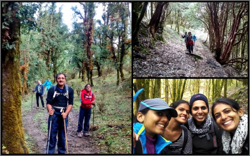


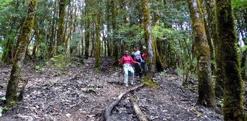
![[Courtesy Ani & Sabari]](https://travellenz.files.wordpress.com/2016/03/img_5008.jpg?w=490)
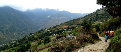
![Countryside [Courtesy Ani & Sabari]](https://travellenz.files.wordpress.com/2016/03/img_5011.jpg?w=490)
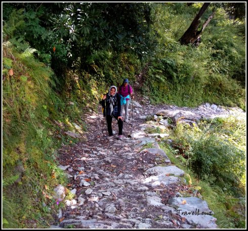
![Stone bridge on the way [Courtesy Ani & Sabari]](https://travellenz.files.wordpress.com/2016/03/img_5018.jpg?w=490&h=435)
![[Courtsey Ani & Sabari]](https://travellenz.files.wordpress.com/2016/03/img_5039.jpg?w=490)
![Crossing Bedni Ganga [Courtesy Ani & Sabari]](https://travellenz.files.wordpress.com/2016/03/img_5056.jpg?w=490&h=370)

![Team at Didna [Courtesy Ani & Sabari]](https://travellenz.files.wordpress.com/2016/03/img_5086.jpg?w=490&h=325)


