This bundle features all 6 lessons from the AQA GCSE Geography Unit 1A section on climate change. Each lesson has a variety of differentiated activities, exam questions with guidance, video clips and worksheets ready to photocopy or print.
The order of the lessons is:-
The Evidence for Climate Change
The Natural Causes of Climate Change
The Human Causes of Climate Change
The Effects of Climate Change
Managing the Impacts of Climate Change
Adapting To Climate Change
I hope this saves you valuable planning time.
https://www.tes.com/teaching-resources/shop/markthegeographer
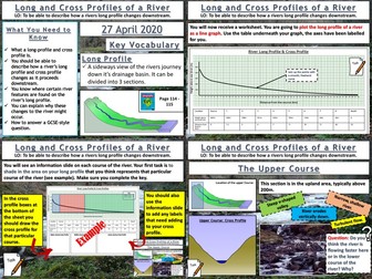
AQA GCSE Geography lesson for the new specification Unit 1C: In this lesson we look at long and cross profiles of a river and how river valleys change shape downstream.
We start with “perfect paragraph”. The pupils read a paragraph describing a drainage basin and they should try to find the errors in the paragraph and what should be added in. We then introduce long profiles, and the pupils will be plotting a long profile of a river on their worksheet. We then look at the upper, middle and lower courses of the river. The pupils shade in these sections on their graph. We complete the worksheet by looking at cross profiles and how river valley shapes change downstream. The pupils create annotated cross sections of the upper, middle and lower courses using the info slides. We finish with a 4 mark GCSE-style question “describe how the shape of a river valley changes downstream”. As always the pupils have some guidance on the question if they need it.
In a nutshell lesson includes:
Perfect paragraph starter.
Long profile plotting exercise.
Cross profile diagram activity.
4-mark GCSE-style question.
Hope this saves you some valuable planning time.
https://www.tes.com/teaching-resources/shop/markthegeographer
AQA GCSE Geography lessons for the Resource Management Section Unit 2C. All lessons are fully resourced, differentiated with a variety of activities and practice questions.
Lessons included are.
The Global Distribution of Resources
Provision of Food in the UK
Provision of Water in the UK
The Provision of Energy in the UK
I hope this saves you some valuable planning time.
https://www.tes.com/teaching-resources/shop/markthegeographer
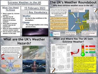
AQA GCSE Geography lesson for the new specification Unit 1A: In this lesson we look at what extreme weather is, what type of extreme weather the UK experiences and whether the UK may experience more in the future.
The lesson has a retrieval practice starter where the pupils choose the places or the circumstances where tropical storms can be found. We then look at the definition of extreme weather. The students complete a map exercise which helps to explain why the UK’s geographical location allows a variety of extreme weather to be experienced. The students then complete a spider diagram on the types of extreme weather, there are some video clips and information slides to help with this which could be a carousel activity. We then complete a map exercise where the students use an atlas to locate where the extreme weather impacted and evaluate how severe the weather event was. We finish with a GCSE-style practice question with some guidance and structure provided for the students.
Hope this saves you some valuable planning time.
https://www.tes.com/teaching-resources/shop/markthegeographer
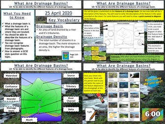
AQA GCSE Geography lesson for the new specification Unit 1C: In this lesson we look at drainage basins and what types of features you find within them.
We start with a photo mystery starter, the pupils only see fragments of a map of the drainage basins of the UK and Ireland. The pupils try to guess what the complete picture might be. This leads onto a discussion about drainage basins and the Amazon Basin in particular. Next we look at the features within a drainage basin. The pupils will work from a worksheet and are given a description of a feature. They must find the feature on the diagram, write the description, and then for some features they draw their own zoomed-in picture of the feature. Following this the pupils get a grid of photographs of the various features and they need to work out what the feature is. The board is editable so they can play bingo as well if you want to create bingo cards.
We finish with a simple post-it plenary based on a GCSE-style question.
In a nutshell lesson includes:
Geographical gallery of contemporary art starter
Worksheet activities on the features of a drainage basin
Photo grid of the features of a drainage basin.
Post-it plenary.
Hope this saves you some valuable planning time.
https://www.tes.com/teaching-resources/shop/markthegeographer
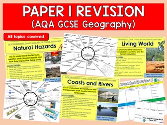
Full series of revision lessons and Resources
Session 1: Natural Hazards Revision
Revision Clock
Blockbuster
Session 2: Living World Revision
Revision Clock
Blockbuster
Session 3: Coasts and Rivers Revision
Revision Clock
Blockbuster
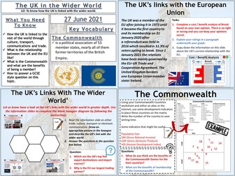
AQA GCSE Geography lesson for the new specification Unit 2B: In this lesson we look at the place of the UK in the wider world.
The lesson starts with a quick retrieval practice quiz true or false quiz. We then introduce some of the organisations that the UK is a member of and how this can give the UK global influence. The pupils then use a hexagon template to create an annotated diagram on our trade, transport, cultural and communication links. We then consider the UK’s relationship with the EU post-brexit and remind ourselves of how the UK left the EU. The pupils complete a cost/benefit analysis of this with explanation. We then look at the Commonwealth and the pupils complete an exercise that looks at the diversity of countries size and economies using indicators (Atlas or internet access needed). We then finish with a GCSE-style practice question with some guidance.
Hope this saves you some valuable planning time.
https://www.tes.com/teaching-resources/shop/markthegeographer
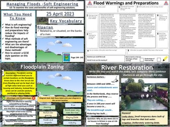
AQA GCSE Geography lesson for the 2016 specification Unit 1C: In this lesson we look at soft engineering methods of flood management.
We start with a retrieval practice grid game based around the work we have undertaken in the rivers unit of work so far. The students then complete a cloze exercise to create a definition of what soft engineering is. The students then investigate flood warnings as issued by the Environment Agency and preparations by completing a guided reading exercise. We then look at three soft engineering strategies in turn: River restoration, flood plain zoning and afforestation. For each method, the students write a description, sort out the advantages and disadvantages and complete a task involving a diagram. There is a short video task on rover restoration. We finish with a 6-mark GCSE style question and there is some guidance for students who need it on how to answer it.
Hope this saves you some valuable planning time.
https://www.tes.com/teaching-resources/shop/markthegeographer
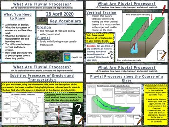
AQA GCSE Geography lesson for the new specification Unit 1C: In this lesson we look at erosion, transportation and deposition.
The starter is “which row is the odd one out”. The pupils need to work out which row has an incorrect term in. Just gets them thinking.
We then look at erosion and when rivers are eroding more effectively. The pupils learn about vertical and lateral erosion and will be making some diagrams in there exercise books. They then receive a worksheet where the processes of erosion and transportation are illustrated, the pupils use an information slide (or sheet if you prefer) and label the processes on and colour code the area of the diagram where that process is displayed. We then look at how these processes vary as you progress down the long profile of a river. The pupils get another worksheet where they read the labels and draw an appropriate diagram in each box to create an illustrated log profile. We finish with a summarising pyramid plenary.
In a nutshell lesson includes:
Odd one out starter.
Vertical and lateral erosion diagram activity
Worksheet on processes of erosion
Worksheet activity on processes of erosion along the course of a river
Summarising pyramid
Hope this saves you some valuable planning time.
https://www.tes.com/teaching-resources/shop/markthegeographer
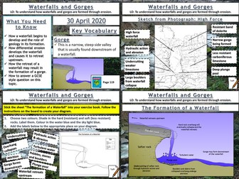
AQA GCSE Geography lesson for the new specification Unit 1C: In this lesson we look at waterfalls and gorges and how they are formed through the processes of erosion.
The starter is a retrieval practice grid filled in for the rivers work so far, but it’s editable.
We then look at how underlying geology plays and important part in the formation of waterfalls, the pupils have some questions to answer and I sometimes get a pupil to teach this bit. We then look at how waterfalls develop, after some teacher exposition the pupils will have an outline diagram of a waterfall with some tasks to complete on the diagram. We then look at the formation of gorges and how they relate to waterfalls. This time the pupils use the diagram on the board to create one themselves. We finish with a sketch from photograph of High Force. After we have introduced the waterfall and given some detail on its formation the pupils will create a field sketch either in a blank box, or using a feint outline, which they can draw over the top of. They then label features etc. We finish with a 6-mark question similar to the 2019 May exam on physical processes and waterfalls/gorges. There is advice and guidance should the pupils need it.
In a nutshell lesson includes:
Retrieval practice grid starter.
Question answer session on how a waterfall starts to form.
Blank outline actvity on the development of waterfalls over time.
Diagram activity on the formation of a gorge.
Worksheet activty on sketching High Force from a photograph.
6-mark GCSE question with guidance.
Hope this saves you some valuable planning time.
https://www.tes.com/teaching-resources/shop/markthegeographer
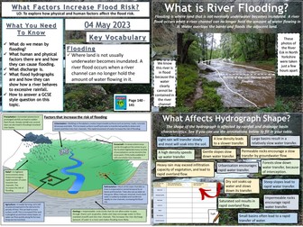
AQA GCSE Geography lesson for the 2016 specification Unit 1C: In this lesson we look at the physical and human factors affecting flood risk and storm hydrographs and what factors affect their shape.
We start with a retrieval practice quiz with ten questions. We begin by looking at the definition of flooding and a brief example by considering the floods around Doncaster in 2019 and 2020. There is a video clip for this. We then look at the physical and human factors that affect flooding. The students have a diagram to annotate and locate an appropriate example on the diagram, they then colour code the annotations into physical and human factors. We then explore the components of a hydrograph. The students have a blank graph to label on the various component parts of the graph. We then look at what factors are likely to affect the storm hydrograph. Here the students have a grid to fill in with annotations from the board. They have to locate where the annotation would logically go on their grid. We finish with a 4-mark GCSE style question and there is some tips for students who need it on how to answer it.
Hope this saves you some valuable planning time.
https://www.tes.com/teaching-resources/shop/markthegeographer
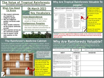
AQA GCSE Geography lesson for the new specification Unit 1B: In this lesson we look at what valuable commodities and services the rainforest provides.
The lesson has a rainforest themed retrieval practice starter. We look at what value the rainforest has to indigenous peoples and why these people may be at threat. Focusing on the Achua tribe we look at a video and complete some guided reading with the students completing some questions relating to the text. We then look at the valuable medicines that come from the rainforest, the students have to complete an annotated ‘rainforest cabinet’ using information from the slide. We then look at essential services. The students read the information on the various services the rainforest provides and rate them according to how important they are and explain why they think this. We finish with a GCSE-style practice question with some guidance and structure provided for the students.
Hope this saves you some valuable planning time.
https://www.tes.com/teaching-resources/shop/markthegeographer
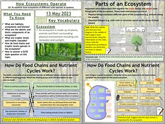
AQA GCSE Geography lesson for the 2016 specification Unit 1B: In this lesson we look at how ecosystems operate, from small-scale ecosystems to biomes.
We start with a retrieval practice task based around coats. We begin by looking at what the biotic and abiotic components of an ecosystem are.
The students are given an example ecosystem and have to categorise the components according to whether they think they are biotic or abiotic. We then look at different scales of ecosystems and look at trophic levels. The students work out which examples belong with which trophic level . We then explore an example of a food chain, using a small-scale ecosystem (a pond) the students have to work out which creatures belong in which trophic level. We then look at biomass in the food chain and discuss why biomass declines at each level. We finish with a 4-mark GCSE style question and there is some tips for students who need it on how to answer it.
Hope this saves you some valuable planning time.
https://www.tes.com/teaching-resources/shop/markthegeographer
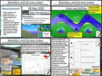
AQA GCSE Geography lesson for the new specification Unit 1C: In this lesson we look at how both meanders and ox-bow lakes are formed by both erosion and deposition.
The starter is a retrieval practice grid filled in for the rivers work so far, but it’s editable.
We then look at a diagram of the Mississippi flood plain and the pupils answer some questions about the archaic meanders that can be seen plotted on the diagram and how they might be formed. We then watch a short video clip on how river meanders get started. We then look at the cross section of a meander and its various features. The pupils get an outline drawing of a meander for them to colour in by numbers to start with, then label the various features on the cross section. The pupils seem to love this colourful neat diagram. The next thing we consider is riffles and pools, after discussing how they are formed the pupils create a diagram in their books for this one. We then watch a video clip on meander formation and there are some colourful diagrams to help teacher explanation. The pupils have a strip to stick in their books, there is a feint outline of the original meander to help them in their drawings. They then explain the process. We finish with a 6-mark question on the formation of ox-bow lakes with some guidance.
In a nutshell lesson includes:
Retrieval practice grid starter.
Question answer session on old Mississippi meanders diagram.
Colour by numbers cross sectional diagram activity.
Diagram activity on the formation of riffles and pools.
Sequential diagram task on ox-bow lake formation.
6-mark GCSE question with guidance.
Hope this saves you some valuable planning time.
https://www.tes.com/teaching-resources/shop/markthegeographer
AQA GCSE Geography lesson for the new specification Unit 2B: In this lesson we look at the changing rural landscapes of the UK.
The lesson starts with a practice task. We then look at a cartoon which is showing rural-urban migration together with other geographical concepts. We then look at the reasons for people moving into rural areas. We then introduce two examples, one of rural population growth (South Cambridgeshire) and the other of rural population decline (Outer Hebrides). The pupils have a task worksheet to complete with various tasks for them to tackle. We finish with a 6-mark practice question with some guidance on how to respond.
Hope this saves you some valuable planning time.
https://www.tes.com/teaching-resources/shop/markthegeographer
AQA GCSE Geography
Tudeley village developement - Pre-release full mock exam 2024.
Laid out as real exams are.
Full mock paper with a range of questions.
40 marks total, designed to be completed in 1 hour.
Updated to reflect the most recent changes AQA have made to the pre-release material
Some activities in this bundle require the blue Oxford AQA GCSE textbook for the new 2016 specification
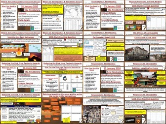
This bundle has all the lessons required to teach the Tectonic Hazards section of unit 1A. The activities are varied and differentiated. Each lesson has a GCSE-style exam question with guidance for the students if needed. All worksheets in a format ready for printing. Some lessons do use the Oxford textbook as I have found this is the best way to teach it.
Hope this saves you some valuable planning time.
Order of the lessons is :-
The Distribution of Earthquakes and Volcanoes
Physical Processes at Plate Boundaries
The Effects of Earthquakes
Responses to Earthquakes
Living With The Risk From Tectonic Hazards
Reducing the Risk From Tectonic Hazards
https://www.tes.com/teaching-resources/shop/markthegeographer
2 resources:
Comprehensive revision guide explicitly linked to the specification. Case studies included.
Student revision work booklet with a variety of activity and exam questions linked to the different sections of the specification.
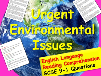
An easy to use reading comprehension pack with three sections of differentiated questions. This activity focuses on urgent environmental issues . It can be used in form time as part of literacy focus, or in an English lesson for KS3/4 GCSE comprehension training.
It is interesting, useful, very easy to use and good to raise awareness of envirornmental issues.
For everything English GCSE and KS3, free and inexpensive, check out my Tes Award nominated shop:
Lead Practioner's English Store
I cannot claim any real credit as the information came from: http://www.tutor2u.net/geography/reference/chi-squared-test
I have merely made a powerpoint around this.
Aimed at A level Edexcel Geography from 2016 with an eye on their coasts fieldwork.
I hope you find this useful.
 Quick View