File:Landscape in Peyriac-de-Mer, february 2018 (05).jpg
Jump to navigation
Jump to search

Size of this preview: 800 × 498 pixels. Other resolutions: 320 × 199 pixels | 640 × 398 pixels | 1,024 × 638 pixels | 1,280 × 797 pixels | 2,560 × 1,594 pixels | 7,295 × 4,542 pixels.
Original file (7,295 × 4,542 pixels, file size: 17.97 MB, MIME type: image/jpeg)
Captions
Captions
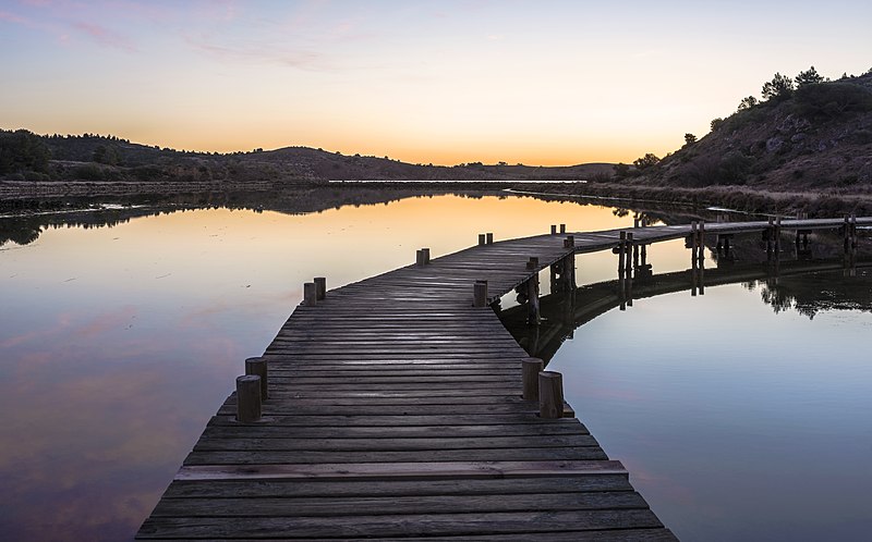
Footbridge reflected in the former salt ponds of Peyriac-de-Mer, Aude, France
Summary[edit]
| Description |
English: Hills, trees and footbridge reflected in the former salt ponds of Peyriac-de-Mer, Aude, France
Polski: Wzgórza, drzewa i kładka odbijające się w wodzie dawnej saliny w Peyriac-de-Mer, w departamencie Aude, we Francji.
Deutsch: Eine Fußgängerbrücke, die sich in den ehemaligen Salinen von Peyriac-de-Mer (Département Aude, Frankreich) spiegelt.
Français : Une passerelle qui se reflète dans les anciens marais salants de Peyriac-de-Mer (France).
Македонски: Дрвен мост преку солена бара во Перјак де Мер, Франција.
|
| Date | |
| Source | Own work |
| Author | Christian Ferrer |
| Permission (Reusing this file) |
I, the copyright holder of this work, hereby publish it under the following license: This file is licensed under the Creative Commons Attribution 4.0 International license.
|
| Other versions |
|

.jpg&action=edit§ion=1)
| Camera location | | View this and other nearby images on: OpenStreetMap |
|---|
.jpg¶ms=043.090566_N_0002.966169_E_globe:Earth_type:camera_heading:90.00&language=en)
Assessment[edit]
.jpg&action=edit§ion=2)
|
.jpg)
This image was selected as picture of the day on Wikimedia Commons for 17 February 2019. It was captioned as follows: Other languages:
Deutsch: Eine Fußgängerbrücke, die sich in den ehemaligen Salinen von Peyriac-de-Mer (Département Aude, Frankreich) spiegelt. Français : Une passerelle qui se reflète dans les anciens marais salants de Peyriac-de-Mer (France). Македонски: Дрвен мост преку солена бара во Перјак де Мер, Франција. |
File history
Click on a date/time to view the file as it appeared at that time.
| Date/Time | Thumbnail | Dimensions | User | Comment | |
|---|---|---|---|---|---|
| current | 16:29, 11 February 2018 | | 7,295 × 4,542 (17.97 MB) | Christian Ferrer (talk | contribs) | User created page with UploadWizard |
You cannot overwrite this file.
File usage on Commons
The following 31 pages use this file:
- User:Eatcha/POTY-2018-Round-1-Results
- User:Nardog/PotY
- User talk:Christian Ferrer/Archive29
- User talk:Christian Ferrer/Archive30
- Commons:Featured picture candidates/File:Landscape in Peyriac-de-Mer, february 2018 (05).jpg
- Commons:Featured picture candidates/Log/February 2018
- Commons:Featured pictures/Places/Natural/France
- Commons:Featured pictures/chronological/2018-A
- Commons:Picture of the Year/2018/Candidates
- Commons:Picture of the Year/2018/R1/Gallery/2018-A
- Commons:Picture of the Year/2018/R1/Gallery/ALL
- Commons:Picture of the Year/2018/R1/Gallery/M02
- Commons:Picture of the Year/2018/R1/Gallery/Waters
- Commons:Picture of the Year/2018/R1/v/Landscape in Peyriac-de-Mer, february 2018 (05).jpg
- Commons:Quality images/Subject/Places/Mixed/Archive3
- Commons:Quality images candidates/Archives March 04 2018
- File:Landscape in Peyriac-de-Mer, february 2018 BW.jpg
- Template:Potd/2019-02
- Template:Potd/2019-02-17
- Template:Potd/2019-02-17 (cs)
- Template:Potd/2019-02-17 (de)
- Template:Potd/2019-02-17 (en)
- Template:Potd/2019-02-17 (es)
- Template:Potd/2019-02-17 (fr)
- Template:Potd/2019-02-17 (hu)
- Template:Potd/2019-02-17 (it)
- Template:Potd/2019-02-17 (mk)
- Template:Potd/2019-02-17 (nl)
- Template:Potd/2019-02-17 (pl)
- Template:Potd/2019-02-17 (pt)
- Template:Potd/2019-02-17 (pt-br)
.jpg)
File usage on other wikis
The following other wikis use this file:
- Usage on be-tarask.wikipedia.org
- Usage on crh.wikipedia.org
- Usage on cv.wikipedia.org
- Usage on en.wikipedia.org
- Usage on fr.wikipedia.org
- Usage on hu.wikipedia.org
- Usage on hy.wikipedia.org
- Usage on it.wiktionary.org
- Usage on ka.wikipedia.org
- Usage on ko.wikipedia.org
- Usage on lbe.wikipedia.org
- Usage on lb.wikipedia.org
- Usage on lez.wikipedia.org
- Usage on mk.wikipedia.org
- Usage on os.wikipedia.org
- Usage on pt.wikipedia.org
- Usage on ru.wikipedia.org
- Usage on ru.wikinews.org
- Usage on sah.wikipedia.org
- Usage on sq.wikipedia.org
- Usage on tt.wikipedia.org
- Usage on uk.wikipedia.org
- Usage on vep.wikipedia.org
- Usage on zh.wikipedia.org
.jpg&oldid=687901119)