

Abstract
Declining groundwater levels are common in parts of the western US, but their impact on the ability of wells to pump groundwater is not known. Here we collate groundwater well records for the western United States and present the recorded locations, depths, and purposes of more than two million groundwater wells constructed between 1950 and 2015. We then use the well records to estimate the percentage of wells that were dry during the years 2013–2015. During the two year period, dry wells were concentrated in rural areas with high agricultural productivity, such as parts of the California Central Valley and the High Plains. Our results support anecdotal evidence that wells used for domestic purposes are more susceptible to drying than wells used for agricultural purposes throughout California's Central Valley because the former tend to be shallower. However, this is not the case in all regions. Our findings suggest that declining groundwater levels are threatening drinking water reliability and agricultural productivity, and consequently, have key implications for both domestic and agricultural water security. Ongoing reductions to groundwater storage are drying groundwater wells in the western US, and this manifestation of water scarcity warrants innovative groundwater management transcending status quos.
Export citation and abstract BibTeX RIS

Original content from this work may be used under the terms of the Creative Commons Attribution 3.0 licence.
Any further distribution of this work must maintain attribution to the author(s) and the title of the work, journal citation and DOI.
Introduction
Unsustainable groundwater pumping, enabled by limited long-term water management, is depleting many western US groundwater aquifers [1–6]. Changes in climate and infiltration can reduce groundwater recharge, also impacting groundwater storage [7]. Excessive groundwater pumping and reductions in groundwater recharge can cause loss of groundwater storage capacity [8], land subsidence [9], streamflow depletion [10], ecosystem harm [11], sea-level rise [12], and seawater intrusion [13]. Although many of the undesirable impacts linked to depletion and the reduction in groundwater recharge have been evaluated, the prevalence of dry wells has not yet been assessed. Mapping dry wells is important because dry wells threaten drinking water access, agricultural yields, and industrial productivity. Furthermore, dry wells interfere with a well owner's legal right to withdraw water, because the well owner is no longer guaranteed a reliable water supply [14].
In the western United States (US)—where 60% of national groundwater withdrawals occur [15]— there is anecdotal evidence that wells are going dry or becoming less productive due to declining water tables (e.g. [16–18]). In California, there is also anecdotal evidence that wells used for domestic purposes are more susceptible to drying than wells used for agricultural purposes [19, 20], because domestic wells are shallower than agricultural wells. Nevertheless, it is unclear if this pattern holds across the western 17 states. If confirmed, such a pattern would raise important questions about groundwater management, because domestic well users tend to withdraw less groundwater than agricultural well users, and because domestic water use for drinking, sanitation, and hygiene is seen as a basic right [21, 22].
Unfortunately, dry wells are not recorded or reported comprehensively in the western US. The lack of well construction information and water level measurements across jurisdictions makes it difficult to assess which wells have been impacted by declining water levels. Well completion records are collated at the county or state scale, but the records are rarely stitched together across jurisdictional boundaries. To our knowledge, the last characterization of groundwater wells at the continental scale was published nearly three decades ago [23]. Consequently, the modern-day spatial density of groundwater wells, their depths and purposes, and the number that have become dry due to declining groundwater levels are unknown.
The objectives of our study are to (i) identify the locations, depths, and purposes of groundwater wells constructed in the western US between 1950 and 2015, (ii) estimate the number of wells that were dry during years 2013–2015 due to declines in local groundwater levels, and (iii) test if domestic groundwater wells are shallower—and, therefore, more vulnerable to drying should groundwater levels decline—than agricultural wells across the western US.
Methods
To meet our first objective, we compiled western US groundwater well data. To meet our second objective, we estimated 2013–2015 well water levels in flatter areas of the western US; identified wells that were likely dry during years 2013–2015; and assessed the sensitivity of our calculation approach. To meet our third objective, we completed practical and statistical significance testing on agricultural and domestic well depths.
Compilation of western USA groundwater well data
We compiled groundwater well construction reports from databases in 17 western states; we refer to this as our constructed well database henceforth. We surveyed state groundwater experts to ensure that we correctly interpreted notation in each database (supplementary information section S2, table S1, available at stacks.iop.org/ERL/12/104002/mmedia). We screened our data for quality (supplementary information section S3), using only wells designed for domestic (domestic, municipal), agricultural (irrigation, livestock), and industrial (commercial, thermoelectric production, primary energy production) uses.
Estimating 2013–2015 well water levels
We analysed water-level data from three sources: (i) US Geological Survey (USGS) (http://groundwaterwatch.usgs.gov/Net/OGWNetworkLTN.asp?ncd=ltn&a=1&d=1), (ii) measured water levels from our constructed well database, and (iii) California's Groundwater Ambient Monitoring and Assessment Program (GAMA) (https://data.ca.gov/dataset/water-data-library-groundwater-level-measurements; supplementary information section S4, figure S7(a)).
We used water level measurements made between 1 January 2013–31 December 2014 from wells with depth information to estimate the 2013–2015 water level. To develop a single water level value for monitoring wells with data available for both the 2013 and 2014 calendar years we: (i) averaged well water level measurements made in 2013; (ii) averaged water level measurements made in 2014; and (iii) averaged values obtained in (i) and (ii). The approach attempted to weight 2013 and 2014 water levels equally.
Well water level measurements made during or after the construction of a new well may not represent equilibrium conditions. To address this concern, we compared 2013–2015 constructed well water level measurements to nearby (<1 km) monitoring well water level measurements in USGS and GAMA monitoring wells with similar well depths (±10 m). Constructed well water levels are similar to nearby USGS and GAMA monitoring well water levels (figure S7(b)), suggesting that constructed well water levels are of reasonable quality for use in our analysis.
We only analysed water level measurements made in wells located in flatter areas (topographic grades <3%). To identify flatter areas, we analysed the CGIAR-CSI SRTM v4.1 digital elevation model (http://cgiar-csi.org). We calculated maximum slopes for each grid cell using elevations of the eight surrounding grid cells. The digital elevation model's grid size (~75 m) is not too coarse to miss local variability, but also not too fine to contain 'noise' or hinder data processing [24].
We estimated the 2013–2015 water table in flatter areas (slopes <3%) by interpolating well water level measurements using an approach common to our field (inverse distance weighting) [4]; we focused our analysis on flatter areas in order to increase the likelihood that a water level measurement provides a plausible estimate of the water level at a nearby (<1–10 km) location. By interpolating measurements of the depth below land surface to water in a well, rather than water table elevations, we implicitly assumed that the water table follows topography between the interpolated points in low gradient areas [25]. This approach introduced limitations to our analysis because western US water tables do not follow topography in some places [26], and because our compilation of piezometric measurements were not spatially continuous (supplementary information section S5). Our estimate of the 2013–2015 groundwater table may be improved by incorporating more piezometric data (e.g. river stage variations and impacts on water tables along river corridors) or by testing other water table elevation estimation approaches (e.g. groundwater models informed by actual piezometric measurements). Applying alternate approaches to estimate water tables could also help assess dry well abundances in steep areas excluded from this analysis.
We used only water level measurements made in wells screened in the shallowest portion of the crust in an effort to exclude wells perforated in confined aquifers, which are likely poor estimates of water table depths. We assumed wells constructed within 100 m of the land surface represent unconfined conditions as applied in the past [27]. To assess the sensitivity of the assumption that wells shallower than 100 m represent unconfined conditions [27] we completed two additional water level measurement interpolations using measurements made in wells (i) shallower than 50 m and (ii) shallower than 150 m (supplementary information sections S4 and S5). Hydraulic heads vary with depth below the water table in many areas, meaning that water level measurements made in deeper wells likely differ from those made in nearby shallower wells (figure S8). If 3D hydrogeological data were available we would quantify depths to semi-confined and confined systems and account for vertical hydraulic gradients. Unfortunately, existing publically-available, continental-scale lithological data only reports alluvial thicknesses up to 50 m [28]. Alluvial thicknesses are imperfect proxies of unconfined aquifer systems (e.g. alluvial aquifers can be (semi)confined). Furthermore, a 50 m thickness cut-off is too shallow to be useful in multiple deep alluvial aquifers critical to our analysis (e.g. California Central Valley, parts of the High Plains).
Identifying dry wells
To estimate which wells have gone dry, we subtracted each groundwater well's depth (from subsection entitled Compilation of western USA groundwater well data) from our calculated 2013–2015 depth to groundwater (from subsection entitled Estimating 2013–2015 well water levels); i.e. [pressure head] = [well depth]−[2013–2014 groundwater level depth]. We only calculate pressure heads in wells where at least one groundwater level measurement has been made between 2013 and 2015 within a 1–10 km radius of the groundwater well (supplementary information section S5). This step is important to constrain our use of the interpolated water table solely to wells located nearby at least one water level measurement; i.e. we only analyse wells nearby one or more control points used in our water table depth interpolation. We use the pressure head to identify dry wells in flat areas: negative values suggest that the well is dry (negative pressure heads are zero in reality), and high positive values indicate that the bottom of the well is much deeper than its modern water level (figure S9). We report fractions of groundwater wells in 10 km by 10 km grids that have gone dry for all grids containing at least n = 20 constructed wells.
Statistical sensitivity analysis of dry well estimates
Our analysis included three key assumptions: (i) water level measurements made in wells shallower than 50–150 m represent unconfined conditions (supplementary information section S5.1, figure S10; tables S21 and S22), (ii) wells with a pressure head of less than zero meters are dry (supplementary information section S5.2), and (iii) water level measurements made within 1–10 km are useful estimates of the water level at the well site (supplementary information section S5.3). In supplementary information section S5.4 we highlight the impacts of these assumptions on our results.
Agricultural and domestic well depth differences
To test if domestic wells are shallower, and therefore more vulnerable to drying, than agricultural wells, we compared agricultural and domestic groundwater well depth distributions within each 10 km by 10 km grid that contains nagricultural_wells≥ 10 and ndomestic_wells≥ 10. We compared medians rather than means, because well depths are not normally distributed (supplementary information section S6, figure S13).
We performed statistical significance testing on grids with practical significance: more than 10 m differences among median agricultural and median domestic well depths. We used the two-sided Wilcoxon rank sum test to test the null hypothesis that agricultural and domestic groundwater well depth distributions are from continuous distributions with equal medians, against the alternative hypothesis that agricultural and domestic wells are not from distributions with equal medians. Because our statistical hypothesis testing is performed on thousands of grids (ngrids = 3487), we estimate the q-value [29] (supplementary information section S6, table S23); q < 0.01 suggests that 1% of tests will result in false discovery.
We map differences between median agricultural well depths and median domestic well depths at 10 km by 10 km grids, and we select six areas to show grid-aggregated histograms of well depths for all wells, agricultural wells, and domestic wells. For each grid-aggregated area, we (i) provide median values to communicate practical significance, (ii) test the null hypothesis that agricultural and domestic groundwater well depth distributions are from continuous distributions with equal medians, against the alternative hypothesis that agricultural and domestic wells are not from distributions with equal medians (supplementary information section S6, table S24), and (iii) present the p-value; p < 0.01 rejects the null hypothesis at the 0.01 significance level, suggesting that agricultural and domestic wells are not from distributions with equal medians.
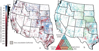
Figure 1. Recorded depths and purposes of groundwater wells constructed between 1950 and 2015. Each point represents the location of a recorded groundwater well. Of the 3.7 million well construction records we collected, two million wells have depth data, known purposes that fit into domestic (self and public supply), agricultural, or industrial categories, and meet other criteria for analysis (supporting information section S2). The most notable well construction data exceptions are in (i) Texas and Washington, where records are limited prior to 2002 and 1992, respectively; (ii) Nebraska and Oklahoma, where domestic well records are limited prior to 1993 and 1984, respectively; (iii) North Dakota, where many records lack information about the purpose(s) of well construction; and, (iv) California, where records are limited or unavailable in numerous counties. (a) Groundwater wells shallower than the median groundwater well depth (55 m) are shown in shades of blue, whereas wells deeper than the median well depth are shown in shades of red. The histogram shows the distribution of the depths of all two million wells. (b) The points are green for agricultural wells, blue for domestic wells, and red for industrial wells (tables S3–S19).
Download figure:
Standard image High-resolution imageResults
Groundwater wells in the West
Recorded well depths average 72 m, have an upper and lower quartile range of 30 m to 92 m, a 5th–95th percentile range of 12 m to 186 m, and a median of 55 m (figure 1(a)). Most wells (96%) have total construction depths that are within 200 m of the land surface. Deep wells (>200 m) are concentrated where confined aquifers and thick alluvial deposits exist, and shallow wells are common on floodplains (figure 1(a)).
The prevalence of domestic, agricultural, and industrial groundwater wells varies across the western US (figure 1(b)). Domestic wells comprise 73% of wells in our dataset and are common in mountainous regions and deserts. Agricultural wells comprise 23% of the total wells in our dataset and are concentrated in key food producing regions. The remaining wells in our dataset (4%) are for industrial purposes and are common in oil-and-gas-rich areas such as the Permian, Fort Worth, East Texas, and Anadarko Basins in Texas, Oklahoma, or Kansas.
Measured water levels in groundwater wells shallower than 100 m have an upper and lower quartile range of 5.3 m to 24.4 m, a 5th–95th percentile range of 2.1 m to 50.5 m, a median of 11.3 m and an average of 17.1 m (figures 2 and S8). Measured well water levels are often shallow close to river corridors (figure 2), where the wells themselves tend to be shallow (figure 1(a)) and where local and regional groundwater flows often support shallow water tables. Well water levels are generally deeper in mountainous regions and where unsustainable pumping has depleted aquifer storage, such as in western Kansas and in California's southern Central Valley.
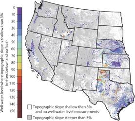
Figure 2. Water level measurements recorded between 2013 and 2015 in western US areas with low topographic slopes (<3% slope). Water levels are shallow along some river corridors, and deeper in regions where groundwater depletion is known to occur (e.g. California's southern Central Valley). Only water level measurements made in wells with depths of shallower than 100 m are shown (n = 59136 of n = 79058 total wells with water level measurements between 2013–2015) in an effort to focus our analysis on shallow unconfined systems (100 m threshold from [27]).
Download figure:
Standard image High-resolution imageOur compilation efforts show that most of the western 17 states have been recording well construction data for at least 40 years through (i) well log, well completion or driller reports, or (ii) water rights and priority databases, but exceptions exist (figure 3; supplementary information sections S2). The most notable well construction data limitations, as indicated by survey responses provided by each state's data manager, are in (i) Texas and Washington, where records are limited prior to 2002 and 1992, respectively (figure 3(a)); (ii) Nebraska and Oklahoma, where domestic well records are limited prior to 1993 and 1984 (figure 3(b)), respectively; (iii) North Dakota, where many records lack purpose information (figure 3(b)); and (iv) California, where records are limited or unavailable in numerous counties (figure 1; figure 3(b); table S1).

Figure 3. Known limitations of groundwater well data. (a) The cumulative distribution of total recorded wells constructed for each state. Each line represents one state, and the colour of the line matches the corresponding state in the inset map. The cumulative distributions highlight historical variability in the quality of groundwater well construction record keeping. For example, some state databases contain records of groundwater well construction since before 1950 (e.g. Montana) whereas others did not begin recording and digitizing groundwater well construction records until more recently (e.g. Texas and Washington; see also supplementary information figure S2). (b) Limitations associated with compiled groundwater well construction record data as indicated by state data managers in our data quality survey. Most of the western 17 states provided a well log, completion or driller report database (see light blue shade). Key limitations with the state groundwater construction databases are marked by black lines, and include biases in the compiled data towards better record keeping of more recently constructed wells (e.g. Texas), of wells of a certain construction purpose (e.g. Nebraska), and of wells in certain regions of the state (e.g. California; see table S1 for details).
Download figure:
Standard image High-resolution imageHotspots of dry wells
By subtracting each well's depth (figure 1) from our estimated groundwater level (figure 2), we estimate the bottoms of 3.3% (uncertainty range: 2.1%–5.5%) of western US wells constructed between 1950 and 2015 are shallower than nearby 2013–2015 water level measurements, implying these 1-in-30 groundwater wells were dry between 2013 and 2015 (figure 4). Our estimate of 3.3% is based on water level measurements made in nearby wells with depths shallower than 100 m, and the uncertainty range represents wells with a total depth that is within ±2.5 m of our estimated 2013–2015 water level. Applying a range of sensitivity analyses, we find that numerous regions in the western US show high prevalence of dry wells (figures S10–S12; table S21).
Across the western US, we estimate that 3.5% (2.3%–5.9%) of domestic wells were dry during 2013–2015, but only 2.8% (1.8%–4.6%) of agricultural wells were dry, implying domestic wells go dry disproportionately often due to their shallower depths in areas where groundwater levels have declined (table S22).

Figure 4. Estimated percentages of wells that were dry across the western US in 2013–2015. Black shaded regions have high topographic slopes (>3%) and were not analysed. Dark grey areas mark regions with slopes of less than 3%, but with insufficient groundwater well data for analysis (i.e. less than n = 20 groundwater wells that each have a water table estimate). Coloured regions are 10 km by 10 km grids with more than n = 20 groundwater wells analysed in this study (i.e. n > 20 analysed groundwater well pressure heads). The map shows the percentage of groundwater wells with estimated water tables that are deeper than the bottom of the well, which we interpret to be dry wells. Modern water tables (years 2013–2015) were determined using water level measurements made in wells shallower than 100 m. The maps show that many wells are likely dry in parts of the western US, including California's southern Central Valley (near Lemoore in Kings County) and New Mexico's Estancia Basin (near Moriarty in Torrance County).
Download figure:
Standard image High-resolution imageDry groundwater wells are concentrated in rural regions, many of which are key to agricultural production (figure 4). Across our studied 10 km by 10 km grids, we estimate that more than 1-in-20 wells were dry in 18.8% (12.9%–29.1%) of grids and that more than 1-in-10 wells were dry in 10.9% (7.0%–17.6%) of grids. Some of the areas where dry wells are common are located where groundwater depletion is widespread and where anecdotal evidence (table S25) suggests wells are drying up, such as near Wilcox in southeast Arizona [30], near Portales in eastern New Mexico [31], and near Lemoore in southern California [32].
Domestic and agricultural well depths
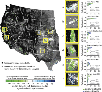
Our comparison of agricultural versus domestic well depths shows that the differences between the median agricultural well depths and the median domestic well depths are practically significant (i.e. > 10 m) in 47% of our 10 km by 10 km study grids (npractically_significant = 1628 of ntotal = 3487). Of the grids with practical significance, 60% are statistically significant (rank sum test, q < 0.01). Of the grids with practical significance, most (72%) have deeper median agricultural well depths than median domestic well depths (ndeeper_agricultral = 1165 of npractically_significant = 1628).
We select six areas to show grid-aggregated distributions of well depths (figures 5(a)–(f)). No practical or statistical significant difference was found between agricultural and domestic well depths in the northern High Plains of Nebraska nor the southern High Plains of west Texas (rank sum, p > 0.01; figures 5(a) and (b)). Agricultural well depths are significantly (practically and statistically) deeper than domestic well depths in the northern California Central Valley, southern California Central Valley and the High Plains aquifer of southwest Kansas (rank sum test, p < 0.01; figures 5(c)–(e)). By contrast, domestic wells are deeper (practically and significantly) than agricultural wells in the Denver area (rank sum test, p < 0.01; figure 5(f)).
Figure 5. Comparison of agricultural versus domestic well depths. (Map) Green grids represent regions where the median agricultural well depth is deeper than the median domestic well depth; blue grids represent areas where the median domestic well depth is deeper than the median agricultural well depth. Black regions show areas with steep topographic slopes (>3% grade) that were not analysed in this study. Grey areas show relatively flat areas (<3% grade) with insufficient groundwater well data for analysis (n < 10 agricultural wells or n < 10 domestic wells). Seven regions are highlighted in yellow boxes, each of which links to the subplots (a)–(f). Each subplot shows the normalized histogram of groundwater well depths for (i) all wells (grey), (ii) agricultural wells (green), and (iii) domestic wells (blue); the horizontal axis represents the proportion of all wells in the specified area. Median domestic and agricultural well depths are similar in many regions of the western US, including the southern High Plains in western Texas (a) and the northern High Plains in central Nebraska (b). Median agricultural wells are deeper than typical domestic groundwater wells in the north (N) and south (S) Central Valley (c)–(d) and in the central High Plains in southwest Kansas (e). Median domestic groundwater wells are deeper than median agricultural wells in the Denver Basin (f ).
Download figure:
Standard image High-resolution image
Discussion
Groundwater wells in the West
Our constructed well database compilation highlights existing data gaps among state databases (figures 1–3) that have implications for groundwater management. Because some wells have productive lifespans exceeding 40 years, absent well construction data for older wells may impede metering and reporting efforts, possibly undercutting the effectiveness of groundwater management. In some states, domestic wells were not initially required to submit well construction reports. Missing information about domestic wells could make it difficult for groundwater managers to assess withdrawals and groundwater sustainability in the region, especially as land-uses change. The current lack of groundwater well depth data may also inhibit assessments of groundwater users' vulnerability to contaminants. The lack of publicly available well records in parts of California impedes efforts to decipher which communities could benefit most from emergency funding designed to relieve water stress [32]. Unfortunately, areas in central and southern California with anecdotal evidence of well drying are also areas where well construction data are unavailable (figure 1).
These aforementioned limitations provide a glimpse into the evolution of strategic groundwater policies—or lack thereof—associated with each state. Mapping wells may lead to better understanding of where groundwater is being extracted [33], and could be used to refine groundwater-fed irrigation maps [34]. Well data are valuable to demand-side planning efforts, such as identifying areas to reform and improve regulations, focus conservation campaigns, or tailor economic incentives. Groundwater well locations and depths can be vital for mapping the impacts of groundwater pumping on surface waters [10]. On the supply-side of groundwater management, well locations can help target optimal areas for managed aquifer recharge projects.
Hotspots of dry wells
We show that a considerable percentage of western US groundwater wells were dry during 2013–2015. In addition to the 3.3% (2.1%–5.5%) of wells that we estimate to be dry during the period 2013–2015, we estimate that 6.3% of well bottoms are still submerged but have pressure heads between zero and five meters, and that 17.5% of wells have pressure heads between zero and ten meters.
The existence of many wells with pressure heads of only a few meters (figure S10) implies that water table declines of only several meters (<10 m) has the potential to dry or reduce the productivity of many wells. It is possible that some of these wells may already be dry at intra-annual or inter-annual timescales, as year-to-year well water levels can vary several meters. In reality, wells go dry when the water table drops below the pump intake, which rests above the bottom of the well. Because the depth to the pump is shallower than the well bottom, our estimates of dry well abundance are likely conservative. Furthermore, well productivity can be impacted even where the water table has not dropped below the pump intake, because groundwater pumping induces a localized drawdown of the water table known as the cone of depression. Estimating the cone of depression at each well would require continental-scale information about groundwater pumping, aquifer transmissivity and storativity—data unavailable at continental scales.
The prevalence of dry wells highlights yet another undesirable impact associated with groundwater storage declines. In cases where a well's useful lifespan has been exhausted due to well drying, a well owner could consider a number of adaptive responses, some of which include: (i) drilling deeper wells, (ii) receiving delivered water via truck, (iii) connecting to centralized water systems, (iv) conserving groundwater where groundwater is being depleted. (i) Constructing deeper wells can burden well owners and municipalities with the high cost of constructing a new well. Moreover, groundwater users in some regions likely face other impediments to deeper well construction, including less transmissive aquifers and saline groundwater at deeper depths. Well depth patterns (figure 1) indicate that well construction may be constrained to shallow depths in some regions by local lithology, water quality, or socioeconomics (i.e. expense of drilling new well for rural well owners), while groundwater users in other regions may be able to adapt by drilling deeper wells. Even in regions where deep aquifers contain fresh groundwater [35], constructing deeper wells is not a panacea to groundwater depletion. Groundwater depletion has other consequences, such as streamflow deprivation and impacts to groundwater dependent ecosystems, which should be considered when managing groundwater resources. (ii) Programs to deliver bulk water by truck have been used in parts of California, but these programs are likely unsustainable long-term solutions. (iii) Connecting to centralized water systems, can burden water users and municipalities with the high costs of constructing new distribution infrastructure. (iv) Conserving water in households and on farms may be achievable in many regions, but requires sustained efforts from the larger community of groundwater users. Overall, drying of groundwater wells caused by groundwater level declines can lead to costly or challenging scenarios.
Domestic and agricultural well depths
We show that median agricultural well depths differ from median domestic well depths by more than 10 m (i.e. practical significance) in 47% of our study grids; the majority of these differences occur because agricultural wells are deeper than domestic wells. Our results support anecdotal evidence that wells used for domestic purposes are more susceptible to drying than wells used for agricultural purposes throughout California's Central Valley. Agricultural wells, however, are not significantly deeper than domestic wells in all regions. In more than half of the grids we analysed median domestic and agricultural well depths are similar. This finding suggests that, all else equal, declining groundwater levels will impact domestic and agricultural wells proportionately in these areas. Consequently, our analysis of dry wells in western US aquifers has key implications for both domestic and agricultural water security.
Our results show that dry wells tend to be concentrated in rural areas, where domestic self-supply wells are common (figure 4). Unfortunately, rural communities often bear the brunt of the impacts of groundwater depletion [22, 32], because these communities are isolated from urban infrastructure and more likely to rely solely on groundwater [36]. Furthermore, rural communities often have limited ability to diversify their economies [37], and constructing new wells can be costly [38]. Although individuals and communities in rural and low-income brackets are eligible for Department of Agriculture grants and loans to drill wells or to connect to public water systems, the accessibility and effectiveness of these programs has yet to be studied extensively (e.g. Rural Repair and Rehabilitation Loan and Grant (section 504) Program, Rural Housing Direct Loan (section 502) Program, Emergency Community Water Assistance Grant Program; www.rd.usda.gov/files/CA-DroughtAssistance.pdf). Rural communities without public supply or surface water options may be most vulnerable to the impacts of dry wells, but communities that rely on groundwater as part of their public water supply are also impacted by drying wells [22]. For each urban supply well that goes dry, it is possible that hundreds or thousands of people may be affected either by curtailed water supplies or requirements to access alternate water sources (e.g. [31]).
Dry groundwater wells also have implications for US agriculture. Groundwater supplies more than 40% of water used for US irrigated agriculture and is often used as a buffer when surface waters are limited (e.g. drought [39]). In 2010, groundwater supplied 36% [15] of the water used for western US irrigated agriculture, and this fraction is likely greater during droughts [6, 7, 40]. Crop yields from irrigated lands often exceed yields from non-irrigated farmlands [41]; it is possible that agricultural productivity may decline where agricultural wells dry up, should producers switch to dryland farming [6, 42].
Implications for groundwater management
Our main findings—(i) there are a range of data gaps among the various state well construction databases, (ii) 1-in-30 wells constructed between 1950–2015 were likely dry during 2013–2015, and (iii) when agricultural well distributions and domestic well distributions differ significantly, domestic wells are usually shallower, and therefore, disproportionately vulnerable to drying—underscore society's need to improve groundwater management. Groundwater is a public interest resource, meaning that it is publicly owned, in most western states (e.g. Idaho § 42–203A; Kansas § 82a-711(a); Utah § 73-3-8). Consequently, effective groundwater management is important to sustainably serve the public by meeting domestic and agricultural water demands.
Our analysis provides the first continental-scale study of groundwater wells in nearly three decades [23], and represents the first continental-scale examination of groundwater infrastructure impacted by declines in groundwater levels. Dry wells in the United States are not recorded, reported, or analysed comprehensively or across jurisdictional boundaries. For instance, California has a system with publicly available information about water shortages [16], but this system is new as of 2014 and relies on voluntary reporting by households. Some state well construction databases include information about plugged or abandoned wells, but the comprehensiveness of these inventories is unclear [43], and the details about why the wells were plugged or abandoned are often unavailable.
Western US groundwater is a strategic resource used for drinking, sanitation, and hygiene by nearly 10 million people through self-supply wells (data from [15]). Groundwater is also critical to irrigated agriculture, increasing the resilience of agricultural production to drought [7]. It is possible that water users will become more dependent on groundwater as climate warms and the timing and fluxes of river discharges change [37]. If current groundwater management follows 'business-as-usual' scenarios, groundwater resources may not be available to effectively aid climate change adaptation efforts. Groundwater regulation has lagged behind surface water regulation, likely because of the difficulty in characterizing aquifers [44]. Early groundwater legislation, such as common law, focused on 'safe yield', a phrase outdated both in its science and its ability to promote sustainability [45, 46]. Although there has been a widespread movement towards more comprehensive regulatory approaches, one of which is groundwater withdrawal permitting [47], the effectiveness of these approaches is unclear. What is clear, however, is that declining groundwater levels are interfering with well owners' legal rights to withdraw groundwater in many areas across the western US, because the well owner is no longer guaranteed reliable water supplies [14]. Overall, water table declines are drying up groundwater wells, and this manifestation of water scarcity warrants innovative groundwater management transcending status quos.
Acknowledgments
We thank G M Hornberger, D Freyberg, J W Kirchner, and J J McDonnell for helpful comments, and M Fodor for cataloguing links to some groundwater drilling datasets. DP was supported by a grant from the SD Bechtel Jr Foundation and a gift from C Smith to Water in the West. We thank Jay Famiglietti and several anonymous referees whose comments led to improvements to our manuscript.