File:1730 Toms Map of Central Africa - Geographicus - Africa-toms-1730.jpg
Jump to navigation
Jump to search

Size of this preview: 800 × 540 pixels. Other resolutions: 320 × 216 pixels | 640 × 432 pixels | 1,024 × 691 pixels | 1,280 × 864 pixels | 2,560 × 1,728 pixels | 3,797 × 2,563 pixels.
Original file (3,797 × 2,563 pixels, file size: 1.32 MB, MIME type: image/jpeg)
Captions
Captions
Add a one-line explanation of what this file represents
| Africa Interior | ||||||
|---|---|---|---|---|---|---|
| Artist | ||||||
| Title |
Africa Interior |
|||||
| Description |
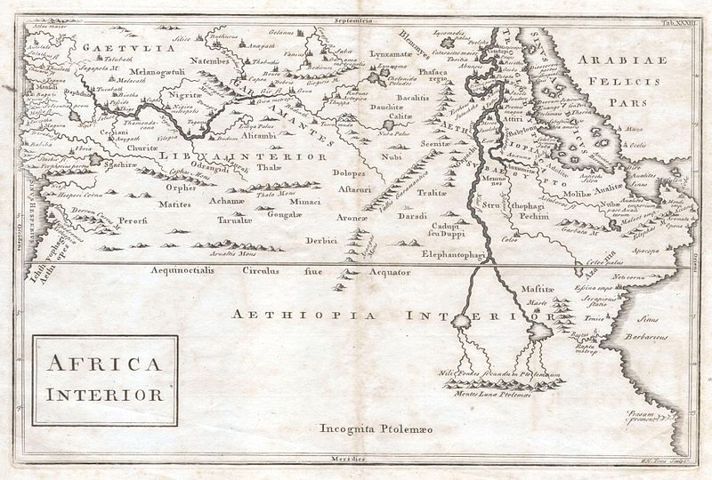
English: A very curious map of central Africa dating to approximately 1730. Covers the mid-section of Africa roughly from the Gulf of Guinea and the Atlantic eastward to the Red Sea and the horn. Extends southward as far as modern day Tanzania. Full of curious and often spurious information. Identifies the kingdoms of the Axuxmites in modern day Ethiopia, as well as the Nubians, the Amanites, and many other mysterious peoples. In the west the map, the Niger River begins and ends without a source or oceanic outlet. Further east, the map follows the course of the Nile river southward, past the lands of the Elephantophagi, to two mysterious lakes. These great lakes, at the foot of the mountains of the moon, were part of a long enduring myth in African cartography that dates to the works of Claudius Ptolemy. In fact, though issued nearly 1600 years after Ptolemy’s death, most of the information here is based directly on his work. Cartographically this map is very similar to Culver’s map of the same name issued in 1736. |
|||||
| Date | 1729 | |||||
| Dimensions | height: 8.2 in (20.9 cm); width: 12.2 in (31.1 cm) | |||||
| Accession number |
Geographicus link: Africa-toms-1730 |
|||||
| Source/Photographer |
|
|||||
| Permission (Reusing this file) |
|
|||||
File history
Click on a date/time to view the file as it appeared at that time.
| Date/Time | Thumbnail | Dimensions | User | Comment | |
|---|---|---|---|---|---|
| current | 01:14, 25 March 2011 | | 3,797 × 2,563 (1.32 MB) | BotMultichillT (talk | contribs) | {{subst:User:Multichill/Geographicus |link=http://www.geographicus.com/P/AntiqueMap/Africa-toms-1730 |product_name=1730 Toms Map of Central Africa |map_title=Africa Interior |description=A very curious map of central Africa dating to approximately 1730. |
You cannot overwrite this file.
File usage on Commons
The following page uses this file: