Autonomous Installations for Monitoring the “Protector Prosperina“ Forest
by
 , and
, and
Emérita Delgado-Plaza
1 ,
,
Gabriel Intriago
1,
Juan Peralta-Jaramillo
1,
Paolo Piedrahita
1 and
Borja Velázquez-Martí
2,* 1
ESPOL Polytechnic University, Escuela Superior Politécnica del Litoral, ESPOL, FIMCP, FIEC, FCV, Campus Gustavo Galindo Km, 30.5 Vía Perimetral, Guayaquil P.O. 09-01-5863, Ecuador
2
Departamento de Ingeniería Rural y Agroalimentaria, Universitat Politècnica de València, Camino de Vera s/n, 46022 Valencia, Spain
*
Author to whom correspondence should be addressed.
Appl. Sci. 2019, 9(19), 4034; https://doi.org/10.3390/app9194034
Submission received: 28 August 2019
/
Revised: 20 September 2019
/
Accepted: 25 September 2019
/
Published: 26 September 2019
(This article belongs to the Special Issue Greenhouse Integrated Photovoltaic System)
Abstract
:Featured Application
Stations implementation using renewable energies for power supply that serve as technical and logistical support for the ecotourism and research activities of the biome in the Protector Prosperina forest.
Abstract
Within the city of Guayaquil, the Protector Prosperina Forest is located, which protects an area rich in biodiversity. To prevent visitors from damaging the forest, the Polytechnic community has established a tourism intervention plan based on sustainability criteria, generating responsible and ecological tourism. Therefore, the project aims to improvement of spaces, signage, and construction of energy systems using renewable energy for lighting and loading of electronic devices, will also, serve as logistical technical support for the operation of the sensor network and information acquisition for the monitoring of diversity forest through audio and video, especially for the protection of those species that are in danger of extinction. In this initiative to raise awareness and promote the protection of the forest and the sustainable use of its resources, autonomous photovoltaic stations have been installed in 5 strategic locations for the development of the aforementioned activities.
1. Introduction
Considering that Ecuador is one of the countries with the highest number of hours of solar radiation per day (12 h/day), with an average irradiation of 4.14 kWh/m2 day, there are two seasons: the rainy and humid season from December to May and the dry season from June to November where the annual total rainfall is approximately 1506.5 mm (National Institute of Meteorology and Hydrology (INAMHI)). the province coast, during the dry season or cold months (June–December) there are average temperatures from 21.65 °C to 30.8 °C, while in the rainy season or the warm season (January–May) there are average temperatures between 22.7 °C and 30.65 °C. In summer days the average irradiation of the protective forest reaches around 360 to 765 W/m2, in rainy seasons (winter season) by the cloudiness of the area you can reach average irradiation between 100 to 600 W/m2 per day [1].
The Protector Prosperina forest located in the Politecnica del Litoral Superior School has a territorial extension of 540 ha, it is a semi-humid forest located at an approximate height of 200 m.a.s.l on the surface of the Guayas River, without rain in the summer and intense rains in winter. It contains a great diversity of species of flora and fauna, mostly indigenous to the area, which allows the analysis and biological studies, hiking, guided tours of the different trails of the place [1].
Escuela Superior Politécnica del Litoral (ESPOL) is currently resuming the initiative to raise awareness of the care and protection of the Prosperin Protective Forest and its environment, thus emerging the need to implement projects that allow the community to become aware of the importance of tropical dry forests.
To this end, as a conservation action, UVS-ESPOL promotes the Environmental Education program within which several projects have been developed to link with the active participation of polytechnic students and teachers, as well as the general public visiting ESPOL’s facilities. Among the most emblematic projects are:
- Ecological Footprint Trail
- Environmental Interpretation Center
- Path—Viewpoint “Mono Aullador“
- Path “Gavilán Dorsigris”: Bird Watching
- Path “The route of dreams”
It is necessary to indicate that the project is part of the Sustainable Development Goals (SDGs), Goal 4: Quality education; It aims to ensure inclusive, equitable and quality education and promote lifelong learning opportunities for all and Goal 7: Affordable and clean energy. It aims to ensure access to affordable, safe, sustainable and modern energy for all. In addition, the stated by the National Plan of Good Living now called “Plan Todo una Vida”, Goal 7 would be fulfilled. Guarantee the rights of nature and promote territorial and global environmental sustainability, whose policies and guidelines are the “Knowing, valuing, conserving and sustainably managing the natural heritage and its terrestrial biodiversity, aquatic continental, marine and coastal, with fair and equitable access to its benefits” [2,3].
Description of the Problem
Currently the natural resources vital for the sustainable development of cities and future generations, are lost or wasted by poor urban policies and by the poor ecological awareness of the population of the area and those groups of people who visit the forest destroying it. To guarantee the protection and recovery of the Protector Prosperina forest, the Linkages Unit with the Society has developed a Tourism Intervention Plan based on sustainability criteria, for this reason, it is necessary to install autonomous support stations in the trails and points of tourist interest that provide security to the visitor and do not affect the environment. Due to the foregoing, the Protector Prosperina Protector Forest does not yet have fully adequate infrastructure such as stops or support posts along the path, and being necessary to incorporate autonomous electrical power systems such as security aspects and charge of electronic devices for visitors and students. In addition, it will serve as logistical technical support for the continuous operation the information acquisition devices for the monitoring of fauna species through audio and video.
Due to the foregoing, the “Prosperina” Protector Forest does not yet have fully adequate infrastructure such as stops or support posts along the path, thus being necessary to incorporate autonomous electrical power systems such as security aspects and charge of electronic devices for visitors and students [3]. In addition, it will serve as logistical and technical support for the continuous operation of acquisition of information devices for the monitoring of fauna species through audio and video.
From the above on, the objective of the project is to implement stations using renewable energies for power supply that serve as technical and logistical support mechanisms for the ecotourism and research activities of the biome in the Protector Prosperina forest.
2. Materials and Methods
The project begins by analyzing the renewable resource of the area such as solar and wind that use as alternative energy for electricity generation. Analyzing the wind resource, by the geography and micro climate of the area (Protector Prosperina Forest) the wind can reach speeds from 1 to 7 m/s, being unstable during the year. For this reason, the use of photovoltaic panels was proposed as an alternative for the energization of the stations located in different parts of the trails forest, therefore proceeds to measure the irradiation of the place.
To achieve the above-mentioned objective, the following working methodology was established:
- Selection and assessment of strategic points of location of the autonomous stations on the path of the Protective Forest, considering several ecological and environmental factors of the place [4]
- Structural design and sizing of the photovoltaic system
- Design of the acoustic and environmental sensor network system for information acquisition of the fauna
- Installation of autonomous stations and of an information acquisition system on the trail and viewpoint sector “Mono Aullador”
2.1. Autonomous Photovoltaic Installations.
Before proceeding with the installation of the autonomous stations used for the monitoring of fauna of the place and lighting and supply of energy charge, we proceeded to identify several strategic points in different trails of the forest (initial selection of 20 points), later it is allowed to discriminate through the assessment of; existence of satellite signal (WIFI), solar radiation of the place, biodiversity of species, road conditions, and damage caused by tourists. It should be noted that the selection of the points for the installation of photovoltaic cells, irradiation measurement (W/m2) was performed during four months [7,8,9].
From this analysis, 6 places were considered as suitable for the installation of autonomous stations. Subsequently, the environmental diagnosis, soil study and a more exhaustive study of the flora and fauna of the place were made. Of the 4 points along the trail, one was eliminated because the presence of a teak forest, deciduous trees that generated too much shade to obtain an important irradiation intensity [10]. Another point was removed due to the presence of a “CEIBO” tree that could generate too much shadow. This point was moved down hill to a location where there appeared to be no obstacles for solar radiation. Following the procedures indicated, irradiation measures were performed at the 4 end points of the trail, as well as at the viewpoint.
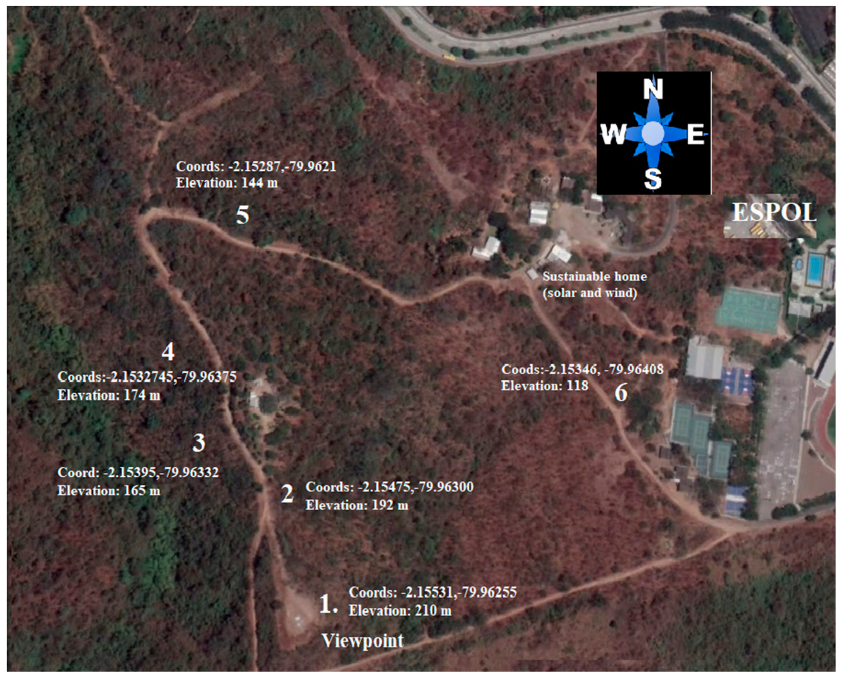
It could be considered that on a sunny day there will be no problems to obtain the irradiation intensity required to generate the desired power using photovoltaic panels [11]. On the other hand, during cloudy days’ low measurements were obtained, which would not generate enough power in the solar panels. Considering that the measures were taken between late May and early July, at the end of the rainy season, there would still be cloudy days with little intensity [12,13]. For the next months, outside of the rainy season, there are expected to be far fewer cloudy days, and the panels will be able to deliver the required power very often. In Figure 1 we show the study area of the protective forest trail.
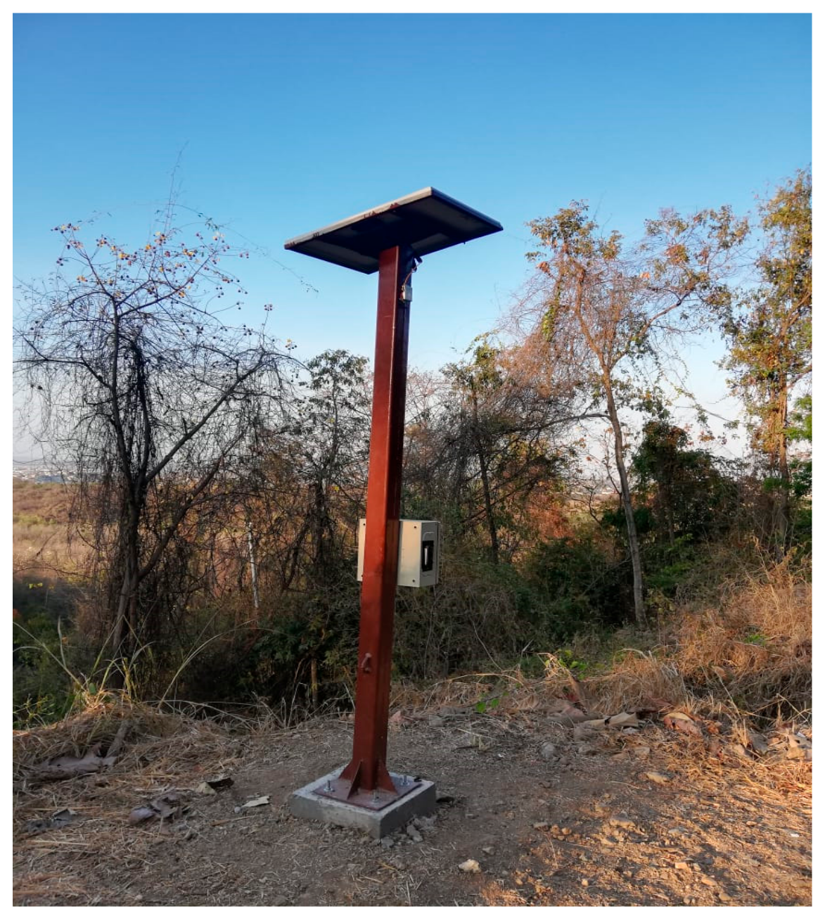
Finally, we installed 3 autonomous stations each of 50 W (point 3, 5, and 6) a station of 200 W in the viewpoint “Mono Aullador” (point 1) and a station of 200 W in the buffer zone of the forest (Sustainable home).
On the other hand, it is necessary to indicate that the design and construction of the autonomous stations have been developed applying the sustainability approach and reuse of materials for the structural part of them. The stations are designed to guarantee the energization of the audio information transmission system, lighting through a control system that constantly illuminates the path around 2 h at night and, in addition, allows charging smaller equipment such as telephones, cameras, among other items.
The design of the autonomous installations, part of the structural analysis using the “Inventor” software, were carried out general plan of the construction with its proper elements (construction material beams M1). After this, the process of cutting, polishing, welded and bolting of the structure was carried out, it should be noted that the materials used are recycled, subsequently, the structures were installed in the 4 selected areas (Figure 2). Finally, the installation of the photovoltaic panels and their complements was carried out. [14,15].
On the other hand, the autonomous system was installed arduino microcontroller, (allows by programming, to be able to manage and control different devices, in a simple and fast way) for the control of the current and voltage delivered by the photovoltaic panel. In addition, for the lighting of a 10 W lamp, which must be lit for 2 h during the night (18:00–20:00 pm), to benefit hikers or visitors. Finally, the installation of an electric current meter allows us to keep track of the amount of energy that is consumed by visitors to the forest [16].
2.2. Documenting Flora and Fauna
The trail “El Mirador” was evaluated throughout the year 2018, and the fauna was documented along the trail using field census techniques for both invertebrates and vertebrates [17] so several censuses were conducted where animals were recorded to each side of the trail. Moreover, the plant cover was evaluated by quadrants of 5 × 5 m placed 5 m off at one side of the path, at a relative distance of 750 m from the beginning of the trail, located 120 m above sea level to highest point at 210 m above sea level [16].
2.3. Information Acquisition System for Faune
To achieve the project’s effectiveness, two stages are established;
First stage; It was planned to expand the capacity of the capture devices for the sending and transmission of data of environmental parameters. The evaluation of data transmission capacity and operation time was made based on the supplied elements such as [18].
Second stage; Enabling the cellular network of the devices or modules that capture data [19].
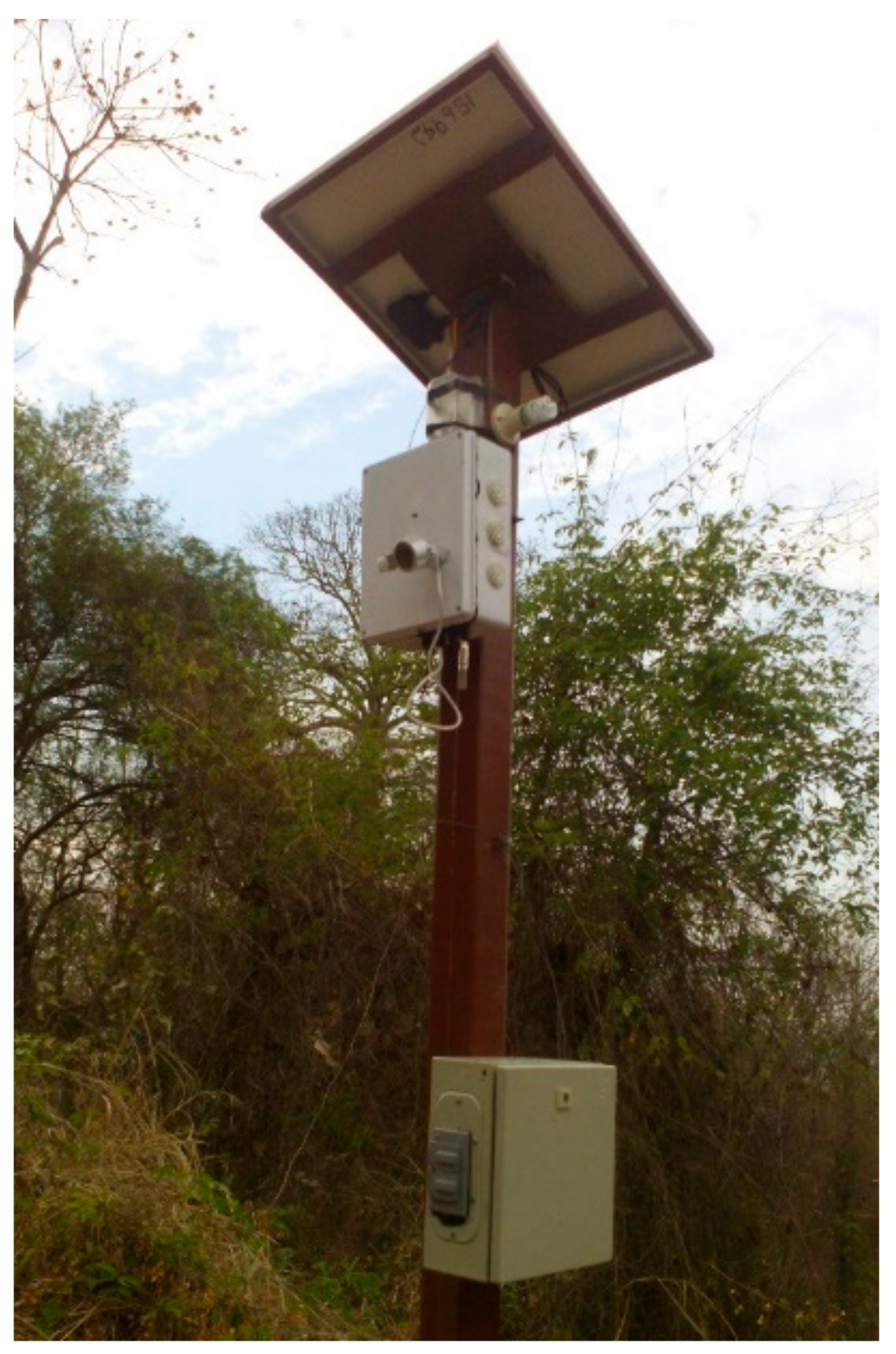
Finally, the devices were located in strategic sites for data collection within the study area, during this phase, the protections of the boxes were designed and they installed the information acquisition systems (Figure 3).
3. Results
3.1. Identification of Flora and Fauna
The Protective Forest has 540 ha, where 3.64% ha represents the study area. Fauna was documented along the trail “El Mirador”, all animals seen and heard up to 100 m at each side of the trail were recorded. The viewpoint has 10.65 ha of real coverage with high lushness and, 9.03 of poor vegetation, zero, within a total study area and path of 19.68 ha.
The trail “El Mirador”, located in the lower area of the forest, is located at 90 to 210 m above sea level (m.a.s.l). This path has an irregular plant cover according to an altitude gradient; at point 1 and 5 there is a coverage of 30%–50%, at point 2 it ranges 50%–70%, point 3 and 4, 30%–50%. No bodies of water were detected on the trail “El Mirador” greater than 10 × 10 m of area. Small runoffs and “albarradas” 5–10 m away from the trail were observed in the field at certain points on both sides (Figure 1).
Wildlife sampling recorded 254 individuals which belonged to 42 identified species. Points 1 and 3 have the highest number of individuals censed during the dry season months. The highest value of species observed was found at point 5 (144 m above sea level) with 84 individuals observed. The points with the lower number of fauna recorded were point 4 with 16 observed species and, point 2 with 10 (Figure 1).
The observation area for birdlife extended up to 150–300 m from the trail “El Mirador”. The similarity between species of fauna for summer at point 6 (118 m.a.s.l) and point 1 (210 m.a.s.l) have a similarity of 42%. Points 3 (165 m.a.s.l) and 5 (144 m.a.s.l) had a 25% similarity to point 6 (118 m.a.s.l). Species distribution patterns can be similar between the lowest area of the trail and the highest area of the trail. Specific biodiversity was assessed with The Shannon Index.
3.2. Acquisition System for Biome Research
A network of acoustic and environmental sensors was implemented in the project to obtain data from; temperature, humidity, audio, movement and images of the trails that are powered by photovoltaic panels. The implementation is achieved through multidisciplinary groups of teachers and students in the areas of telecommunications, telematics, electronics and automation, biology and mechanics. The data acquired by the modules of the network are stored in the servers of the ESPOL and are available for the use of the community [20,21,22,23].
First stage; It was planned to expand the capacity of the capture devices for the sending and transmission of data of parameters such as temperature, humidity, audio, movement, and images. The evaluation of data transmission capacity and operation time was made based on the supplied elements such as: cell phones, electronic cards among others. In this stage, the energy capacity was also expanded. At the beginning, the module had a turned-on time of three hours of continuous operation. After several experiments and testing situations, the on time reached twelve hours of continuous operation. This result was sufficient for our needs because the module will capture temperature and humidity each ten minutes, on the other hand, the audio will be recorded spending ten minutes in a time of three minutes. Regarding the images, they will be captured asynchronously each time the movement sensor detects an animal.
Second stage; Enabling the cellular network of the devices or modules that capture data. In this part, besides enabling access to the cellular network, communication protocols were evaluated, electronic elements that were part of the devices were selected, data transmission was implemented and the transmission results were evaluated. We discovered that the cellular network was available for each station, but the fastest network was H+, and the slowest was Edge. To determine the network, a simple cellphone app was used, which show the power of the signal in decibels and the type of network. Other networks were assessed such as LoRa, Zigbee, Xbee, and Sigfox, the problem with these networks was that they added a level of difficulty because they are mesh networks, and additional hardware was needed, which might have increased the budget of the project, this stage was done in coordination with the autonomous photovoltaic installations.
Continuing with the protection and color of the information acquisition modulo, the recommendations issued by the ESPOL group of biologists were taken, indicating that an affectation to the fauna and flora would damage the data collection, because no animal would approach the animals installed devices. The information acquisition modules were located in the autonomous photovoltaic installations, being the strategic sites for data collection within the study area. Matte colors were selected for the module; being gray for the box, camera and temperature/humidity sensor, black color for the microphone and the movement sensor has a matte white. After ten weeks of a testing period in real environmental conditions, the modules did not show any damage besides cleaning them the dust on it.
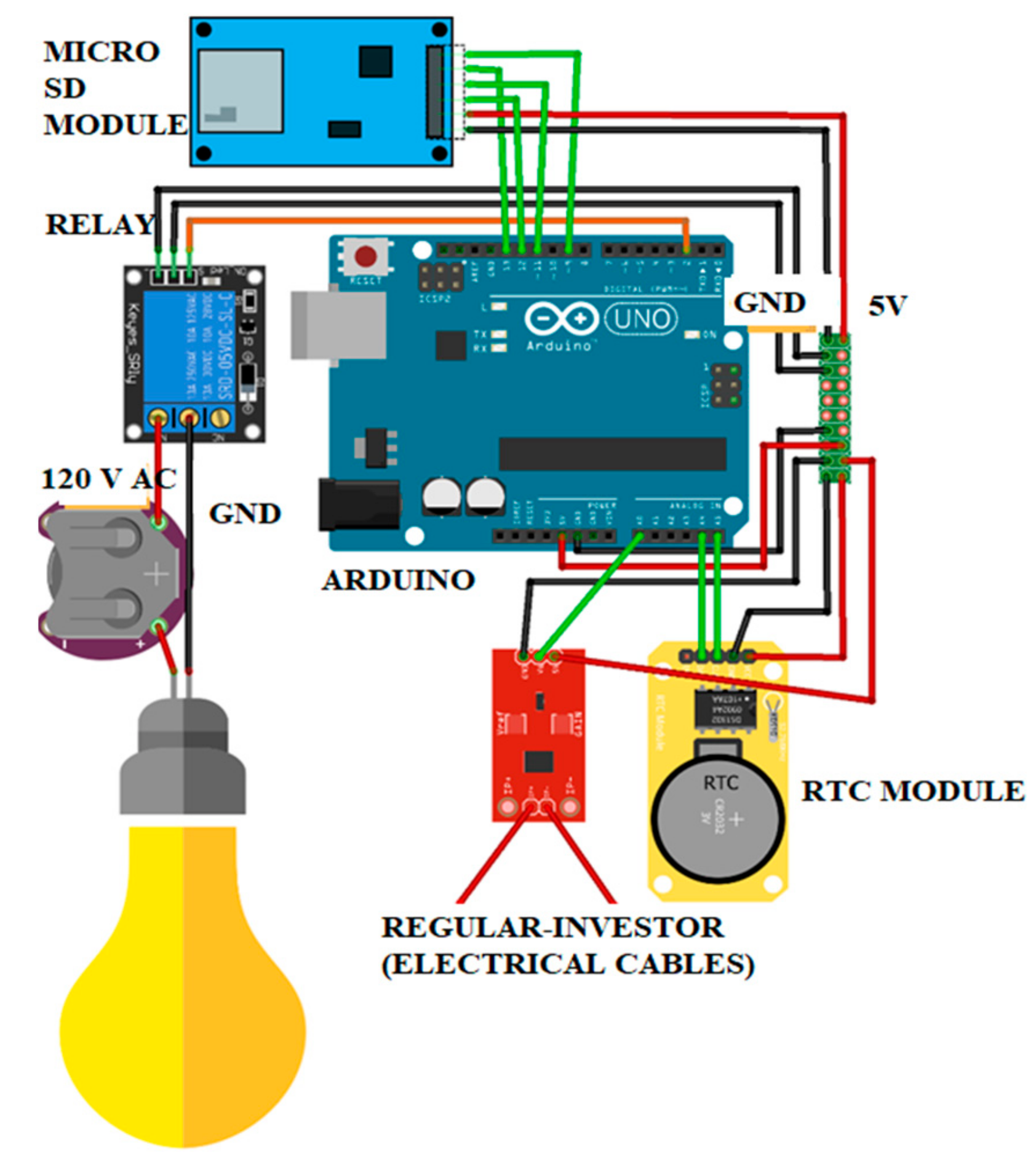
Finally, a small circuit with an Arduino, a relay, and a photovoltaic sensor for the ignition of a 5 W spotlight have been added to the photovoltaic system for 3 h at night. Since the Arduino can only work with a maximum of 5 volts, a relay was used to turn on illumination directly connected directly to the source. The system will work with a photovoltaic sensor, which emits an analog signal, so when it is dark enough and the analog signal is less than the set limit, the Arduino will emit a digital signal to the relay allowing the current to pass from the source of energy to the spotlights. An initial consumption energy of 10 Wh was considered (Figure 4).
- The Arduino UNO is coded a program written in The C language to fulfill the following functions:
- The acquisition of ACS712-05A current sensor data and the processing of this information to bring it to power consumption in kWh.
- Obtaining the date and time of the real-time clock module (RTC DS231), this module allows to store the date, even if it does not receive power from the Arduino UNO since it has an external 3.3 V battery.
- Activate the relay that allows you to turn on the spotlight(s) when the time is in the range of 7 p.m. and 10 p.m.
- Store the date and daily power consumption on the microSD card module at 6 p.m.
On the other hand, in the case of night lighting, the program made using Arduino has the option to easily change the interval at which you want to illuminate the autonomous stations, the date of the watch is also set in case the battery is spent. All Arduino modules used (microSD, Relee and PSTN) and current sensor use for their 5 V operation which are provided by the Arduino UNO 5 V output from its internal voltage regulator. In the Arduino an expansion module (Shield) was placed to weld the cables of the different sensors and make the connections to 5 V and ground (GND) described above, moreover the device is powered by the inverter via USB connection.
4. Discussion
The paper presents a study case associated with the implementation of low-cost monitoring networks, ease of operation and maintenance, as a tool for the control and evaluation of biodiversity and climate change in a protected area [24]. In addition, the autonomous stations are considered passive mechanisms of observation and control, which can be used as an appropriate solution as part of the sustainable management of protected areas due to their low environmental impact and use of resources renewable energy consumption under the distributed generation criterion.
Moreover, it can be mentioned that prevention studies and construction methods for the installation of autonomous stations, on the trail, are of vital importance for the present ecosystem it is already shown that the inhabitant species would move due to invasions of the population [25].
The growing need to manage biodiversity with a more timely and relevant knowledge of the biome with minimal degree of human intervention and with environmental awareness incrementing that requires greater access to Information on the state of biodiversity in the world [26]. This scenery, leads to find engineering solutions that allow continuous adaptation and improvement according to information needs and technological advances that allows us to alert on variations in the conditions ecosystems and species including possible changes in weather.
Due to the complexity of the area being a protective forest, the native species of the place (fauna) must be protected from the hunters who enter the trails, at the same time uncontrolled tourism that damage in some way the flora of the place. This is why audio and video systems have been installed in strategic points, of the forest not only to identify the fauna and flora of the place, but also to control the problems previously exposed.
While true, the solution adopted for the energization of these systems was based on the construction and installation of small photovoltaic stations of 50 W with a base height of 3 m (component of the installation; 50 W polycrystalline photovoltaic, inverter, regulator, 7 A battery), and in addition the “Mirador” sector was used for a 200 W installation being a strategic point, so that visitors can make use of energy to charge low-capacity electronic equipment. For the construction of such stations it was necessary to comply with environmental standards regarding non-harmful material and degradable to the environment, color, height, visual impact analysis, among other variables that may affect the natural ecosystem.
The use of photovoltaic systems to some extent is an energy-acceptable solution for urban and rural areas that allows energy savings in housing. [27] indicates that the estimating solar PV potential at a city scale is very useful as a support system for policy-making and strategy planning, it also has several disadvantage, just as; integrate decentralized solar PV electricity production with energy storage and electrical grid so as to manage the energy demand of neighborhoods or communities. A typical photovoltaic solar system consists of four basic elements; photovoltaic module, charge controller, the inverter and battery when necessary [28]. The monocrystalline (m-Si), polycrystalline (p-Si, also referred to as multicrystalline, mc-Si) cells are the most used on a commercial level [29,30]. From what the author indicates, our system works with polycrystalic photovoltaic panels (it registers higher demand in the national market), although they have an efficiency of 15%, we are supplied by the energy system at the stations.
On the other hand, justifying the issue of not using centralized energy systems this project for reason that are recommended for case isolated communities that have a real lack of electricity, and to some extent it is advantageous to install photovoltaic solar panels instead of investing in expensive infrastructures for connections to the grid of 3 to 5 homes located in remote areas. To some extent, in the case of using photovoltaic panels in a forest is much more complex, due to several factors involved as they are; shadows by trees that would affect the audio and video system by turning it off completely, checking every two months of the control boxes that may be affected by ants or nesting some bird.
From the literary review, several authors present studies indicating that energy can be guaranteed, if the number of photovoltaic modules and the orientation of the greenhouse are correctly chosen for the latitude and the time of year [31], and the location of the modules is important when looking at reducing the shadow effects that can generate large energy losses [32]. Even, they have been made flexible panels to supply energy to autonomous systems and to replace the shading elements, thus achieving normal crop development [33,34]. These studies show results of uses of photovoltaic panels to energize greenhouse ventilation systems (use of 3 to 4 photovoltaic panels, regular, inverter, battery) and research involving a detailed analysis of the operation of the photovoltaic panel. For our case, it is the same principle and components for energizing an audio and video system. In general, there is little information from studies submitted where results of the operation of photovoltaic facilities in forests are installed and analyzed for the acquisition and recording of the fauna information of the site.
The total cost of the project to build, install and put into operation the 5 audio and video boxes (3 stations with metal structures and 2 boxes placed in the treetops), is $3400, being the price of the $500 information acquisition module (microphone, camera, box, data acquisition system) and photovoltaic stations are priced at $300 dollars (polycrystalline solar panels, regulator, inverter, cables, arduinos, and sensors, the cost of metallic materials is not considered for reasons that are reused). From an economic point of view, the installation of autonomous photovoltaic stations is economically feasible from the above-mentioned in relation to the installation of a central photovoltaic plant of 1000 W, in addition to being a protected area, large installation cannot be performed. In the future it is intended to install more module in the treetops with a small photovoltaic panel of 25 W.
On the other hand, it is important to note that prior to the installation of photovoltaic stations, solar irradiation of the site was recorded for two years, in order to determine the optimal angle of inclination of photovoltaic breads (angle between 10° to 12°). This arduous process was carried out because the photovoltaic panels when fixed in the direction of the North, it should be considered the summer and winter seasons especially this last where the trees sprout. By way of example as results we can indicate that, the minimum irradiation in the area at the “Mirador” station was 3.13 kWh/m2 day.
From the above, it is essential to select a set of accumulation system as is the case of the battery that will serve us to store energy for at least 3 days of autonomy, especially in the case of summer in the case of Ecuador, between the months of June, July, and August present the low irradiations of the year.
In the case of inverters and regulators, it is recommended to use voltages 12 V for low current, in addition to the structure covering such equipment, in order to avoid the entry of insects that shorten the life of such complements.
As has been explained in the results of the article, the use of Arduinos for the control of lighting at night times, and, for recording energy consumption, you can analyze and quantify the energy consumed by the audio and energy-efficient equipment connected by trail visitors (cell phones, tables, cameras).
Finally, this project linked to Sustainable Development Goals 4, quality education “Ensuring inclusive, equitable and quality education and promoting lifelong learning opportunities for all” and Goal 7, affordable and clean energy “Ensure access to affordable, reliable, sustainable and modern energy.” the design, construction, assembly, operation and maintenance of systems, devices, and equipment that transform the available energy into useful ways are inherent challenges for technical professionals and researchers, where not only technology is applied to supply energy for the operation of a device, but environmental awareness must be taken into account, such as the reuse of metallic materials or other types of non-degradable materials that can be used to build structures in a forest.
5. Conclusions
The implementation of the project helped the development and articulation of the ecotourist activities of the Protector Prosperina forest providing support for logistic to visitors with a great experience by incorporating aspects of sustainability and resilience in relation to management of this forest.
The autonomous stations operating from renewable energy will reduce the impact to the minimum of the ecosystem derived by the placement of traditional energy vectors, on the other hand, it will facilitate the activities within the forest, therefore, the result of the implementation of the project, is reflected in performance indicator and the Sustainable Development Goals (SDGs), set by United Nations agencies, Goal 7: Affordable and Clean Energy. “Ensure access to affordable, reliable, sustainable and modern energy for all”.
The use of reusable metallic materials will reduce the cost of building photovoltaic stations to 30%, adding also that these stations were built by the students of the institution as a community project. It is necessary to emphasize, that the final design of the structure of the stations is based through the guidelines established by the Ministry of Environment, where it sets maximum height an installation, colors and materials that can be used in a forest.
An easy to maintain and assemble system of audio and video equipment has been designed, with very simple operation. The polycrystalline photovoltaic panel, when generating electric current during the day, is stored in two 7A batteries that are connected to the audio and video information acquisition system, which records data every 10 min. This signal, using the telephone network, is receptiated to ESPOL’s telecommunications lab. One of the batteries located in the main station box is also connected to an inverter, used as a power supply for the Arduino and the luminaire timer.
A network of acoustic and environmental sensors was developed that recorded data on temperature, humidity, audio, movement, and images of fauna in the Mirador del Bosque Protector trail, where 254 individuals with 42 species of fauna have been identified. Finally, these systems allow monitoring of threatened species in the area such as: Amazon parrots, red-fronted parakeets, gray-cheeked parakeets, and one vulnerable species, the rufous-headed chachalaca. An autonomous system able to record audio, videos, and photos is of great importance for fauna documentation. Usually monitoring fauna species requires great field efforts to estimate for example bird diversity and their movement patterns. With an autonomous system for audio recording would shed light on animal movement ecology according to breeding, migrating and others overlooked behaviors of animals [35]. The information these devices gather contributes with more knowledge for biodiversity conservation.
Author Contributions
Methodology, validation, formal analysis and writing—original draft preparation: E.D.-P. and G.I.; investigation system photovoltaic: J.P.-J.; writing—flora and fauna: P.P.; formal analysis and review: B.V.-M.
Funding
This research was funded by ESPOL, Vinculum with the Society Department.
Acknowledgments
(RISIGED) RED IBEROAMÉRICA DE SISTEMAS HÍBRIDOS DE GENERACIÓN DISTRIBUIDA. UVS Unidad de Vínculos con la Sociedad, ESPOL.
Conflicts of Interest
The authors declare no conflict of interest.
References
- Peralta, J.; Lopez, A. Tese de Doutoramento: Modelamiento Computacional del Recurso Solar y Eólico para aplicación de Sistemas de Energía Renovable. Ph.D. Thesis, Universidade de Santiago de Compostella, Santiago de Compostela, Spain, 2015. [Google Scholar]
- Peralta, J.; Delgado, E.; Lopez, A.; Sosa, I.; Otero, C. Identificacion y Evaluacion del Potencial de Recursos Renovables en el Ecuador y su Viabilidad de Desarrollo Local. In Proceedings of the 3rd Argentine Congress of Mechanical Engineering (III CAIM), Buenos Aires, Argentina, 3 October 2012. [Google Scholar]
- Neira, A.; Benitez, A.; Peralta, J. Rediseño del Sistema de Gestión Energético de la Comunidad Cerrito de los Morreños. 2015. Available online: http://www.dspace.espol.edu.ec/xmlui/handle/123456789/34386 (accessed on 30 June 2016).
- CONELEC. Atlas Solar del Ecuador con Fines de Generación Eléctrica. 2008. Available online: http://energia.org.ec/cie/wp-content/uploads/2017/09/AtlasSolar.pdf (accessed on 6 September 2018).
- Al-Dafaie, A.M.A.; Dahdolan, M.-E.; Al-Nimr, M.A. Utilizing the heat rejected from a solar dish Stirling engine in potable water production. Sol. Energy 2016, 136, 317–326. [Google Scholar] [CrossRef]
- Pimentel, D. Biofuels, Solar and Wind as Renewable Energy Systems; Springer: New York, NY, USA, 2008. [Google Scholar] [CrossRef]
- Peralta, J.; Delgado, E.; Sosa, I. Análisis y evaluación de la información meteorológica disponible para la prospección del recurso eólico en el perfil costero ecuatoriano. In Proceedings of the XXI Congreso de Ingeniería Española, Elche, Spain, 11 November 2016. [Google Scholar]
- Barriga, A.; Delgado, E.; Guevara, J.; Peralta, J. Introducción al Estudio de Fuentes Renovables de Energía; Iniciativa Latinoamericana de Libros de Texto Abiertos (LATIn): Guayaquil, Ecuador, 2014. [Google Scholar]
- Rydh, C.J.; Sandén, B.A. Energy analysis of batteries in photovoltaic systems. Part I: Performance and energy requirements. Energy Convers. Manag. 2005, 46, 1957–1979. [Google Scholar] [CrossRef]
- Villages, S. Fuentes de Energía Sostenible Para el Desarrollo Rural y la Resiliencia Climática de Comunidades Sin Conexión a la red en Centroamérica, el Caribe y Méxic; Smart Villages: Punta Cana, Dominican Republic, 2016. [Google Scholar]
- Diab, F.; Lan, H.; Zhang, L.; Ali, S. An Environmentally-Friendly Tourist Village in Egypt Based on a Hybrid Renewable Energy System—Part Two: A Net Zero Energy Tourist Village. Energies 2015, 8, 6945–6961. [Google Scholar] [CrossRef]
- Wermager, S.; Baur, S. Energy Analysis of a Student-Designed Solar House. Energies 2013, 6, 6373–6390. [Google Scholar] [CrossRef]
- Schuetze, T. Integration of Photovoltaics in Buildings—Support Policies Addressing Technical and Formal Aspects. Energies 2013, 6, 2982–3001. [Google Scholar] [CrossRef]
- Vasiliev, M.; Nur-E-Alam, M.; Alameh, K. Recent Developments in Solar Energy-Harvesting Technologies for Building Integration and Distributed Energy Generation. Energies 2019, 12, 1080. [Google Scholar] [CrossRef]
- Uski, S.; Rinne, E.; Sarsama, J. Microgrid as a Cost-Effective Alternative to Rural Network Underground Cabling for Adequate Reliability. Energies 2018, 11, 1978. [Google Scholar] [CrossRef]
- Khandakar, A.; Chowdhury, M.E.H.; Kazi, M.-K.; Benhmed, K.; Touati, F.; Al-Hitmi, M.; San Pedro Gonzales, A., Jr. Machine Learning Based Photovoltaics (PV) Power Prediction Using Different Environmental Parameters of Qatar. Energies 2019, 12, 2782. [Google Scholar] [CrossRef]
- Sutherland, W. Ecological Census Techniques, 2nd ed.; Cambridge University Press: Cambridge, UK, 2006. [Google Scholar]
- Mabunda, E.N.; Joseph, K.M. Microcontroller-Based Strategies for the Incorporation of Solar to Domestic Electricity. Energies 2019, 12, 2811. [Google Scholar] [CrossRef]
- Milousi, M.; Souliotis, M.; Arampatzis, G.; Papaefthimiou, S. Evaluating the Environmental Performance of Solar Energy Systems Through a Combined Life Cycle Assessment and Cost Analysis. Sustainability 2019, 10, 2539. [Google Scholar] [CrossRef]
- Mukaro, R.; Carelse, X.F. A microcontroller-based data acquisition system for solar radiation and environmental monitoring. IEEE Trans. Instrum. Meas. 1999, 48, 1232–1238. [Google Scholar] [CrossRef]
- Benghanem, M. Measurement of meteorological data based on wireless data acquisition system monitoring. Appl. Energy 2009, 86, 2651–2660. [Google Scholar] [CrossRef]
- Benghanem, M. A low cost wireless data acquisition system for weather station monitoring. Renew. Energy 2010, 35, 862–872. [Google Scholar] [CrossRef]
- Torres, M.; Muñoz, F.; Muñoz, J.V.; Rus, C. Online monitoring system for stand-alone photovoltaic applications. Analysis of system performance from monitored data. J. Sol. Energy Eng. 2012, 134, 034502. [Google Scholar] [CrossRef]
- Fuentes, M.; Vivar, M.; Burgos, J.M.; Aguilera, J.; Vacas, J.A. Design of an accurate, low-cost autonomous data logger for PV system monitoring using ArduinoTM that complies with IEC standards. Sol. Energy Mater. Sol. Cells 2014, 130, 529–543. [Google Scholar] [CrossRef]
- Coelho, V.N.; Weiss Cohen, M.; Coelho, I.M.; Liu, N.; Guimarães, F.G. Multi-agent systems applied for energy systems integration: State-of-the-art applications and trends in microgrids. Appl. Energy 2017, 187, 820–832. [Google Scholar] [CrossRef]
- Faheem, M.; Shah, S.B.H.; Butt, R.A.; Raza, B.; Anwar, M.; Ashraf, M.W.; Ngadi, M.; Gungor, V.C. Smart grid communication and information technologies in the perspective of Industry 4.0: Opportunities and challenges. Comput. Sci. Rev. 2018, 30, 1–30. [Google Scholar] [CrossRef]
- Assouline, D.; Mohajeri, N.; Scartezzini, J.-L. Large-scale rooftop solar photovoltaic technical potential estimation using Random Forests. Appl. Energy 2018, 217, 189–211. [Google Scholar] [CrossRef]
- Gonçalves Vasconcelos Sampaio, P.; Aguirre González, M.O. Photovoltaic solar energy: Conceptual framework. Renew. Sustain. Energy Rev. 2017, 74, 590–601. [Google Scholar] [CrossRef]
- Lan, Z.; Li, J. Photovoltaic Technology and Electricity Saving Strategies for Fixed-Velocity-Measuring System. Indones. J. Electr. Eng. 2014, 12, 4419–4426. [Google Scholar] [CrossRef]
- Gangopadhyay, U.; Jana, S.; Das, S. State of Art of Solar Photovoltaic Technology. J. Energy 2013, 2013, 764132. [Google Scholar] [CrossRef]
- Kozai, T.; He, D.; Ohtsuka, H.; Kamiya, I. Simulation of Solar Radiation Transmission into a Lean-to Greenhouse with Photovoltaic Cells on the Roof. Environ. Control Biol. 1999, 37, 101–108. [Google Scholar] [CrossRef]
- Kadowaki, M.; Yano, A.; Ishizu, F.; Tanaka, T.; Noda, S. Effects of greenhouse photovoltaic array shading on Welsh onion growth. Biosyst. Eng. 2012, 111, 290–297. [Google Scholar] [CrossRef]
- Serrano, I.; Muñoz-García, M.A.; Alonso-García, M.C.; Vela, N. Evaluation of the use of solar panels as a shade in greenhouses. In Proceedings of the 7th Iberian Congress of Agricultural Engineering and Horticultural Sciences, Madrid, Spain, 26–29 August 2013; pp. 2056–2061. [Google Scholar]
- Aroca-Delgado, R.; Pérez-Alonso, J.; Callejón-Ferre, A.J.; Velázquez-Martí, B. Compatibility between Crops and Solar Panels: An Overview from Shading Systems. Sustainability 2018, 10, 743. [Google Scholar] [CrossRef]
- Castro, I.; De Rosa, A.; Priyadarshani, N.; Bradbury, L.; Marsland, S. Experimental test of birdcall detection by autonomous recorder units and by human observers using broadcast. Ecol. Evol. 2019, 9, 2376–2397. [Google Scholar] [CrossRef] [Green Version]
Figure 1.
Location map of the autonomous stations.

Figure 2.
Autonomous stations of 50 W. Sendero “Mirador” Escuela Superior Politécnica del Litoral (ESPOL).
Figure 2.
Autonomous stations of 50 W. Sendero “Mirador” Escuela Superior Politécnica del Litoral (ESPOL).

Figure 3.
Network of acoustic and environmental sensors.

Figure 4.
Control circuit diagram.

© 2019 by the authors. Licensee MDPI, Basel, Switzerland. This article is an open access article distributed under the terms and conditions of the Creative Commons Attribution (CC BY) license (http://creativecommons.org/licenses/by/4.0/).
Share and Cite
MDPI and ACS Style
Delgado-Plaza, E.; Intriago, G.; Peralta-Jaramillo, J.; Piedrahita, P.; Velázquez-Martí, B. Autonomous Installations for Monitoring the “Protector Prosperina“ Forest. Appl. Sci. 2019, 9, 4034. https://doi.org/10.3390/app9194034
AMA Style
Delgado-Plaza E, Intriago G, Peralta-Jaramillo J, Piedrahita P, Velázquez-Martí B. Autonomous Installations for Monitoring the “Protector Prosperina“ Forest. Applied Sciences. 2019; 9(19):4034. https://doi.org/10.3390/app9194034
Chicago/Turabian StyleDelgado-Plaza, Emérita, Gabriel Intriago, Juan Peralta-Jaramillo, Paolo Piedrahita, and Borja Velázquez-Martí. 2019. "Autonomous Installations for Monitoring the “Protector Prosperina“ Forest" Applied Sciences 9, no. 19: 4034. https://doi.org/10.3390/app9194034
Note that from the first issue of 2016, this journal uses article numbers instead of page numbers. See further details here.