Explained: What makes Cyclone Fani unique, all you need to know about deadliest cyclones in India
Timing and strength are two factors that make Cyclone Fani different from most other tropical cyclones in this time of the year. Cyclone Fani developed near the Equator and this allowed it to gather massive strength and moisture as it could travel a long distance over the sea.
")

Cyclone Fani, which has been classified as an extremely severe cyclone (ESC), is the 10th such cyclone to hit India in May in past 52 years. Data from the India Meteorological Department (IMD) show that the last time an extremely severe cyclone hit India in May was in 2004. The other years when such cyclones were witnessed in May are: 1968, 1976, 1979, 1982, 1997, 1999 and 2001.
Generally, extremely severe cyclones hit India's east coast in the post-monsoon season (October-December). IMD data on cyclones that hit India between 1965 and 2017 show that the country has weathered 39 extremely severe cyclones in these 52 years. Of these, nearly 60 per cent (23) were between October and December.
The India Meteorological Department (IMD) classifies cyclones on the basis of the maximum sustained surface wind speed (MSW) they generate.
READ | Cyclone Fani batters Odisha, Bengal, Bangladesh evacuates 5 lakh people
The cyclones are classified as severe (MSW of 48-63 knots), very severe (MSW of 64-89 knots), extremely severe (MSW of 90-119 knots) and super cyclonic storm (MSW of 120 knots or more). One knot is equal to 1.8 kmph.
WHAT MAKES CYCLONE FANI SPECIAL
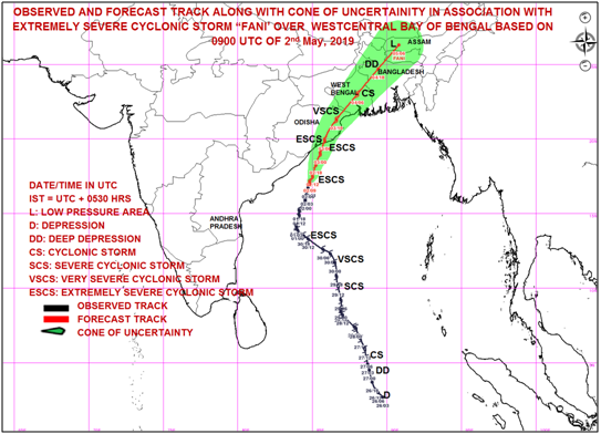
Timing and strength are two factors that make Cyclone Fani, pronounced as Foni, different from most other tropical cyclones in this time of the year. Cyclone Fani started developing around April 25 and has made a landfall this morning in Odisha on the east coast.
Traversing for nearly 10 days over the sea allowed Fani to gather such strength that it is now classified as an extremely severe cyclone. Generally, tropical cyclones over the Bay of Bengal have a lifespan of four-seven days. But Cyclone Fani is different.
What makes Cyclone Fani special is its trajectory. Fani started developing around the Equator and moved upwards. The long journey allowed it to gather a lot of moisture and momentum, resulting in strong winds.
It has been observed that cyclones/hurricanes/tornados that spend a long time travelling over the sea are generally more powerful than the ones that hit the landmass within a few days.
The reason is that the longer duration at sea allows storms to gather more water and momentum and thus generate stronger winds.
Another aspect that makes Cyclone Fani special is its trajectory. Fani started developing around the Equator and moved upwards (see image below). It thus has had a much longer journey from its starting point to the point where it made a landfall, than other cyclones that generate in the Bay of Bengal.
(Click on the image for a zoomed version.)
The IMD had first predicted that Cyclone Fani would make a landfall in Tamil Nadu but the forecast was updated as the cyclone altered its course. Had Cyclone Fani made its landfall in Tamil Nadu, it was possible that its strength would have been lower than its present strength because a landfall in Tamil Nadu would have meant that Fani would have covered a shorter distance over the sea.
Most cyclones that generate exclusively in the Bay of Bengal become relatively weaker by the time they reach the Indian landmass. However, the case with Cyclone Fani is different since it developed almost close to the Equator.
The World Meteorological Organisation (WMO), a United Nations body that monitors weather conditions, had said the extremely severe Cyclone Fani will make a landfall in Odisha with wind speeds of more than 170 km/h.
However, even after making the landfall, the cyclone will move north-northeastwards and strike West Bengal as a severe cyclone and is expected to hit Bangladesh on May 4 as a cyclonic storm.
This means that besides having covered a long journey over the sea (during which Cyclone Fani collected massive amount of moisture), the cyclone will also travel considerable distance over the land.
A (terrifying) look at the precipitable water accompanying #CycloneFani, where deep orange = >60mm H2O, basically the entire #BayofBengal. Flooding also threatens #Bangladesh. Updates at https://t.co/yFMM6Q1Jj2 pic.twitter.com/wQXLe3H6FM UW-Madison CIMSS (@UWCIMSS) May 2, 2019
The WMO has also warned that low-lying districts in Odisha are very likely to be flooded because a storm surge (rising of sea level due to storm) of about 1.5 metre height above astronomical tide is expected when Cyclone Fani hits Odisha.
The timing of Cyclone Fani is important because the cyclone started developing in April, a month that has historically seen very few cyclones that were categorised as extremely severe.
Between 1965 and 2017, India was hit by 145 cyclonic storms that were classified as severe, very severe, extremely severe and super cyclonic storm. Of these, only seven (5 per cent) were in April and 27 (18 per cent) in May.
Most of these cyclones (90 i.e. 62 per cent) were generated between October and December.
Even after making the landfall, the cyclone will move north-northeastwards and strike West Bengal as a severe cyclone and is expected to hit Bangladesh on May 4 as a cyclonic storm.
Madhavan Rajeevan, secretary in the Ministry of Earth Sciences in a tweet said, "In the past (1891-2017) only 14 severe tropical cyclones were formed in April over the Bay of Bengal and only one storm crossed the Indian mainland. Cyclone Fani is the second storm forming in April and crossing the mainland. The last time it happened was Cyclone Nargis that devastated Myanmar in 2008."
In the past (1891-2017) only 14 severe tropical cyclones formed in APRIL over Bay of Bengal Only one storm crossed the Indian main land. Cyclone FANI the second storm forming in April and crossing main land. Last severe cyclone NARGIS in 2008 devastated Myanmar @Indiametdept pic.twitter.com/jSP2rCmN2N Madhavan Rajeevan (@rajeevan61) April 30, 2019
TWO SOURCES OF CYCLONES:
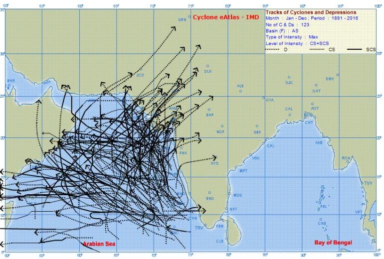
The Indian subcontinent experiences cyclones from two basins: the Bay of Bengal basin and the Arabian Sea basin. Of the two, more cyclones are generated in the Bay of Bengal and cyclones here have also been more severe than the one generated over the Arabian Sea.
One of the reasons why tropical cyclones are more prone to the Bay of Bengal is that its surface temperature is more than that of the Arabian Sea. Tropical cyclones generally need a temperature of around 28 degrees Celsius. The Bay of Bengal is more conducive to this than the Arabian Sea. (Read more on this and other aspects here.)
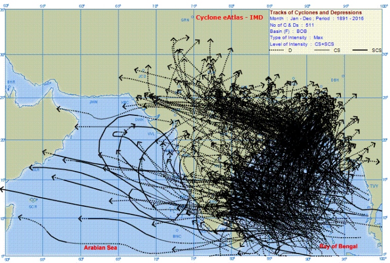
Data on cyclones that hit India over the past 126 years also back this theory. On analysing IMD data we find that between 1891 and 2017, India weathered 305 cyclones that were classified as severe and above.
Of these, 75 per cent (i.e. 229) were generated in the Bay of Bengal basin.
Another peculiarity with the Bay of Bengal is that it is known for its potential in generating dangerous high storm tides. When these tides and cyclonic storms coincide, it becomes a major killer.
According to the India Meteorological Department, "Out of 10 recorded cases of very heavy loss of life (ranging from about 40,000 to well over 2,00,000) in the world due to tropical cyclones, nine cases were in the Bay of Bengal and the Arabian Sea."
Five of these were in Bangladesh, three in India and one in Myanmar.
World's highest recorded storm tide measuring 45 feet occurred in 1876 during the Bakherganj cyclone near Meghna Estuary, Bangladesh.
In fact, IMD says that the world's highest recorded storm tide measuring 45 feet occurred in this region. It was way back in 1876 during the Bakherganj cyclone near Meghna Estuary, Bangladesh.
REGION'S GLOOMY PAST WITH FURIOUS CYCLONES
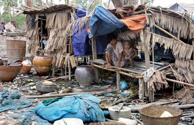
The Indian subcontinent is considered to be one of the worst-affected regions by tropical cyclones, with the region having weathered some of the deadliest cyclones in world history.
According to the Nation Cyclone Risk Mitigation Project (NCRMP), the Indian subcontinent is exposed to "nearly 10 per cent" of the world's tropical cyclones. NCRMP's data analysis shows that between 1980 and 2000, on an average annually 370 million people were exposed to cyclones in India.
A 2014 report of the World Meteorological Organisation, a United Nations organisation on weather monitoring, states that cyclonic storms have been the main cause of deaths due to natural disasters in Asia between 1970 and 2012. A majority of these cyclone-related deaths have occurred in India and Bangladesh.
The report--Atlas of Mortality and Economic Losses from Weather, Climate and Water Extremes--states that between 1970 and 2012, Asia suffered 2,681 natural disasters, of which 35 per cent (938) were storms.
When it comes to deaths, cyclonic storms were responsible for 76 per cent of all deaths caused by natural disasters in Asia in this period. (The report estimates 9.15 lakh deaths were caused due to natural disasters in Asia and 6.95 of them were related to tropical cyclones.)
The top three deadliest disasters in this period were all tropical cyclones. Two of them hit Bangladesh (in 1970 and 1991) and one hit Myanmar (Cyclone Nargis in 2008). The total deaths caused by just these three cyclones was 5,77,232.

(Click photo for a zoomed version.)
Of the 10 most severe natural disasters (in terms of deaths) that struck Asia between 1970 and 2012, eight were tropical storms that hit India, Bangladesh and Myanmar.
In terms of economic loss, Asia suffered a loss of $789.8 billion in these 42 years and 30 per cent of it was due to cyclonic storms.
Taking a global picture, the 10 deadliest disasters that hit the world between 1970 and 2012 included three cyclones in Bangladesh and one in Myanmar.
In fact, the 1970 cyclone in Bangladesh caused the greatest number of deaths (3 lakh) in any natural disaster in the world. The Bangladesh cyclone shared the top place with the 1983 drought in Ethiopia that killed the same number of people.

Besides this, analysis of the WMO data show that between 1970 and 2012, 7,77,861 people were killed due to storms (cyclones/hurricanes/tornadoes). However, 89 per cent of the deaths (6.95 lakh) were caused in Asia, and primarily in Bangladesh, Myanmar and India.
HOW CYCLONES CAUSE DAMAGE
Cyclones are powerful storms that generate strong windspeeds and have the potential to trigger sudden and heavy rain in the affected areas. There are basically three aspects related to cyclones that have the potential to cause destruction-flooding due to rising sea, destruction caused by strong winds and damage due to heavy rains.
Between 1970 and 2012, 7.77 lakh people were killed due to storms (cyclones/hurricanes/tornadoes) world over. But, 89% of these deaths (6.95 lakh) were caused in Asia, and primarily in Bangladesh, Myanmar and India.
When a cyclone is formed over the sea, it generates strong winds along it. These winds have the potential to generate storm surges. A storm surge is an abnormal rise in the sea level due to a storm (cyclone, hurricane etc).
A storm surge becomes dangerous because it has the potential to flood low-lying areas along the coast. It can drown humans and animals, destroy infrastructure and damage environment by eroding beaches, flooding vegetation, among others.
The second dame-causing aspect of cyclones is the strong winds that are generated by the storm. These strong winds that accompany cyclones can uproot trees, electricity poles, shatter houses etc. This is a common phenomenon in the United States of America which regularly weathers strong hurricanes.
The third aspect with cyclones is their ability to cause sudden, heavy and prolonged rain in the affected areas. This causes floods in rivers, pollutes drinking water and if combined with storm surge, it becomes a double whammy.
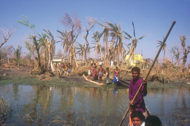
Unfortunately, all the three factors occur at the same time when a cyclone makes a landfall. The IMD states that of three factors, it is storm surge that is most catastrophic and causes widespread destruction. "Past history indicates that loss of life is significant when surge magnitude is three metres or more and catastrophic when five metres and above," it says.
A possible reason for this could be that not much can actually be done against rising sea waves, especially if they are more than 3 metres in height. Storm surge becomes more dangerous if their timing coincides with the timing of high tides.
The author tweets at @mukeshrawat705 and can also be reached out at Facebook.
ALSO READ | 20 years before Cyclone Fani, Super Cyclone killed 10,000 in Odisha
ALSO READ | How Cyclone Fani got its name and what it means
ALSO READ | Why Bay of Bengal storms are more severe
ALSO READ | How are cyclones named?
ALSO READ | Cyclone Fani: Dos, don'ts and helpful links for those in harm's way
ALSO WATCH | Director IMD explains strength of Cyclone Fani and its impact