Calendar & Checklist
For calendar of events Aug’23 — Sep’24 scroll down.
*****************************************
Birding on your own? Over 80 detailed birding sites in L.A. County.
Printable PDF of field trips & programs for 2023-24
Click Image below for printable PDF of the Malibu Lagoon 2020 Checklist.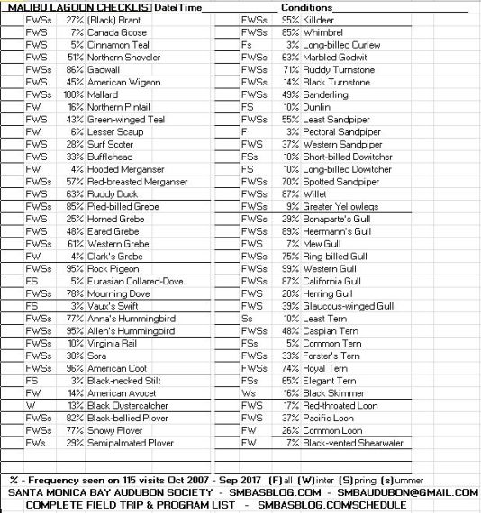
Official California checklist not significantly changed since 2020.
PDF print directions for the checklist will appear.
Afterwards, to return to this page, close that tab.
The file should be printed double-sided.
Cut into four sections to produce four complete double-sided checklists.
*****************************************************
Covid-19 is still out and about, but the below is what we plan to do. Always check the blog for announcements of upcoming events. Such announcements appear approximately 10 days and 3 days prior to trip.
SMBAS SCHEDULE OF FIELD TRIPS AND PROGRAMS 2022-2023
* = Subject to change. Always check our blog for updates.
“Status Unknown” = Trip will almost certainly run as scheduled unless Covid-19 outbreak occur.
Some event titles are links. Click them for trip description & directions.
® Reservation signup is required on some trips, sometimes for Covid protocol, always check the blog. Notify the Leader that you’re coming and they’ll be more likely to wait for you if you’re late.
Questions or no internet access? Call Adrian Douglas (310-393-5493) the week before to confirm the field trip and location.
Day Date Event Leader/Speaker
August 2023
Sun 27 Malibu Lagoon 8:30 am & 10 am ® SMBAS
September
Sat 16 Coastal Cleanup Day 9 am – Noon
Sun 24 Malibu Lagoon 8:30 am & 10 am ® SMBAS
October
Tues 3 Evening Zoom Program 7:30 pm “Birds of Cuba” with Alvaro Jaramillo
Sat 14 Huntington Central Park 8 am Liz Galton
Sun 22 Malibu Lagoon 8:30 am SMBAS
November
Tues 7 Evening Zoom Program 7:30 pm “Gray Vireos in Baja” with Dr. Phil Unitt
Sat 11 Ballona Fresh Water Marsh 8 am Jean Garrett 213-522-0062
Sun 26 Malibu Lagoon 8:30 am SMBAS
December 2023
Tues 5 Evening Zoom Program 7:30 pm “Evolution of Avian Flight” with Dr. Ashley Heers
Sat 9 Newport Back Bay 8:00 am Chuck Almdale
Sat 16 Butterbredt Christmas Count 8:30 am Chuck Bragg
Sat 23 Butterbredt Xmas Rain Date 8:30 am Chuck Bragg
Sun 24 Malibu Lagoon 8:30 am SMBAS
Sun 31 L.A. Christmas Count S.M. area 7am Woodlawn Cemetery, Lu Plauzoles 310-779-0966, contact Lu before 28 Dec.
January 2024
Sat 13 Antelope Valley Raptor Search Cancelled. See below.
Sat 13 Bette Davis Park & Glendale Narrows Path 8am Chuck Almdale
Sun 28 Malibu Lagoon 8:30 am SMBAS
February
Tues 6 Evening Zoom Program 7:30 pm “Aeroacoustics Lab at UCR” with Dr. Chris J. Clark
Sat 10 Madrona Marsh 8 am Jean Garrett 213-522-0062
Sun 25 Malibu Lagoon 8:30 am SMBAS
March
Tues 5 Evening Zoom Program 7:30 pm “Coevolution of Cowbirds and their Hosts” with Dr. Pablo Weaver
Sat 9 Sepulveda Basin 8 am Chuck Almdale
Sun 24 Malibu Lagoon 8:30 am SMBAS
April
Tues 2 Evening Zoom Program 7:30 pm “Great Black-backed Gulls, their food, and stable isotope analysis” with Dr. Kristen Covino of LMU
Sat 13 King Gillette 8 am Chuck Bragg
Sun 28 Malibu Lagoon 8:30 am SMBAS
May
S/S 4/5 Morongo Valley Sat 3pm/Sun 7:30am Jean Garrett 213-522-0062
Tues 7 Evening Zoom Program 7:30 pm “Red and Lilac-crowned Parrots in SoCal” with Brenda Ramirez
Sat 11 Malibu Creek State Park 8 or 8:30 am Leader: TBD
*Sat xx BirdLA Day – Time/Location TBA STATUS UNKNOWN
Sun 26 Malibu Lagoon 8:30 am SMBAS
June
Sat 15 Mt. Pinos Birds & Butterflies 8am Jean Garrett
Sun 23 Malibu Lagoon 8:30 am SMBAS
July
Sun 28 Malibu Lagoon 8:30 am SMBAS
August
Sun 25 Malibu Lagoon 8:30 am SMBAS
September 2024
Sat 14 Coastal Cleanup Day 9 am – Noon
Sun 22 Malibu Lagoon 8:30 am SMBAS
® Trip ran as scheduled
Signup is required on some trips, always check the blog. Notify the Leader that you’re coming and they’ll be more likely to wait for you if you’re late.
If you have no internet access (or have questions), call Adrian Douglas (310-393-5493) the week before to confirm the field trip and location.
An un–updated list of California Bird Festivals is also on our blog.
Return To calendar top
BIRDING SITES: DESCRIPTIONS AND DIRECTIONS
Return To Top
Return To Calendar
Angeles Crest, Charlton Flats, Chilao, Buckhorn. A yearly trip to the Alpine habitat – nice and cool while the city sweats. Join us for such birds as Steller’s Jays, Band-tailed Pigeons, nuthatches, Brown Creepers and White-headed Woodpeckers. It’s a lovely place for a picnic too, so bring an elegant repast if you wish.
Directions: Meet on Highway 2 (Angeles Crest Highway) just north of the intersection with Highway 210 (Foothill Freeway) in La Canada. We will carpool up Angeles Crest Highway. A National Forest pass ($5/day per car) is required for those without a Golden Eagle or equivalent pass. The forest pass is available at Sports Chalet, Adventure 16, Big 5, or the Clear Creek Visitor Center on the way up Angeles Crest. Bring snacks, lunch and drinks.
Antelope Valley Raptor Experience. This is a great trip for the raptor enthusiast. We will bird primarily the central and northern portions of the Antelope Valley, but will utilize recently reported sightings. The most likely raptors will be: Red-tailed Hawk, Ferruginous Hawk, Kestrel, Prairie Falcon, Northern Harrier and Black-shouldered Kite. Other possible species include Rough-legged Hawk, Cooper’s and Sharp-shinned Hawks, Golden Eagle, Merlin, and Long-eared Owl. We also keep our eyes open for Mountain Plovers, Long-billed Curlew, Mountain Bluebirds and other interesting wintering species.
This is an all-day trip. Bring lunch, drinks, snacks and additional water. Dress for the weather.
Directions: Carpools will gather at a North Hills meeting area. Allow 1/2-hour drive time from Santa Monica to the carpool meeting place. For directions to the meeting place or additional information, contact the leader.
Return To Calendar
Ballona Jetty and Fresh Water Marsh. The breakwaters at Marina del Rey (the Ballona Jetty) are a good place to find rock-loving birds you don’t get at the beach, as well as the usual suspects in the gull and tern community and perhaps an unusual sparrow or two. After exploring the jetty we will go to the opposite end of the wetlands and bird the freshwater marsh next to Lincoln Blvd. This marsh has an ever-expanding bird list that has passed 150 species.
Directions via Freeway: San Diego Fwy (I-405) south to Marina Fwy (CA-90), west to Culver Blvd. off-ramp and turn left. Cross the Lincoln Blvd. overpass and continue west as Culver merges into Jefferson Blvd. Continue as below.
Directions: From Lincoln Blvd. in Playa del Rey take Jefferson Blvd. towards the ocean. Jefferson will merge into Culver Blvd as you continue. Turn right on Pacific Ave (almost at the end of Culver) and go to about 64th Ave. where you will find a free parking lot between Pacific Ave. and the Del Rey Lagoon.
Meet in the parking lot by the lagoon.
Return To Calendar
Ballona Freshwater Marsh. Everyone should visit this newest birding hot spot in LA County. Open since Spring ’03, its bird list is already over 150 species, with rarities often appearing. Our first trip of the fall will show you around this small but productive wetland.
Family Guide: easy walking, open vistas, well-suited to any family and children.
Directions: Located just south of Marina del Rey on the southwest corner of Lincoln & Jefferson Blvds. Parking (free) is only along the south side of Jefferson, next to the wetlands.
Return To Calendar
Bolsa Chica Ecological Reserve in Huntington Beach has long been an excellent location to see shorebirds. In addition to all the usual shorebird, duck and seabird suspects, we’ll look for: Western & Clark’s Grebes, Reddish Egret, Osprey, Avocets & Stilts, Semipalmated Plover, both Yellowlegs, Red Knot, Baird’s & Pectoral Sandpipers, Dowitchers, Phalaropes, various terns including the (not-so-common) Common Tern, and the Belding’s race of Savannah Sparrow.
Family guide: 2-3 miles walking on pavement, boardwalks and dirt trails. Morning temperatures start cool.
Directions: San Diego Fwy (#405) south to Garden Grove Fwy (#22) east. Exit almost immediately on Bolsa Chica Rd. Go south on Bolsa Chica Rd. to Warner Ave. Turn right on Warner Ave. to Pacific Coast Hwy, passing the parking lot . Go left (south) on PCH past the traffic signal and make a U-turn at the first turn-around on the divided highway and return to the preserve entrance. Meet there. Either way, allow 50-60 minutes travel time from Santa Monica. Meet in the parking lot.
Return To Calendar
Butterbredt Spring Christmas Count. This is the one trip every year where you can count on meeting real birders, the kind that bring their cross-country skis when the weather turns iffy. No espresso-sipping wimps on this trip! All seriousness aside, dress warmly, bring $5 for the compilation fee, pack a lunch and snacks and be ready to spend all daylight time (it gets dark around 4:30 p.m.) in the Butterbredt count circle as we do our part to count all the birds that were too macho to fly south for the winter.
Link to National Audubon Society history of Christmas Counts
Link to access to Christmas Count data. Butterbredt Code = CABS
Directions: Contact the coordinator for exact instructions (the count circle instructions are different from our regular field trips to Butterbredt). We’ll be happy to arrange carpools if you don’t want to do any driving. Family guide: long car ride, possible cold weather; gotta love the birds.
Return To Calendar
Butterbredt Spring Halloween. Join us on our annual Halloween Campout! Travel will be on graded dirt roads. Birds we hope to see are the typical desert species (Golden Eagle, Sage Sparrow, etc.) and fall migrants such as (we hope) large flocks of Pinyon Jays. Bring a pumpkin for the annual Carving Exhibition and Ghostly Tree Display.
Family guide: great fun for children over 10. In fact, we would like to encourage families to attend this camping trip. We have been invited to stay at Sageland Ranch, home of Keith Axelson. There will be camping space for all, but please bring enough water for cooking and washing, and some firewood would be greatly appreciated too. You can cook on the main campfire or on one of the barbecues.
Participants need to phone or email the leader to sign-up for this trip. They will be given directions, time and place of meeting, and be asked to sign a release form which will be available at the beginning of the trip or by sending a SASE to leader.
Return To Calendar
Butterbredt Spring Spring Trip . Our annual spring camping weekend at the Butterbredt Spring Wildlife Sanctuary and the riparian habitat of Kelso Creek, surrounded by the high desert. Birds we will see are desert residents, spring migrants (one year we saw all eleven western warblers at the spring), and specialties such as Piñon Jays and Golden Eagles. Travel will be on graded dirt roads, passable by almost any car. We will probably camp at Sageland Ranch, near Kelso Creek and north of Kelso Valley. Don’t leave Mojave without filling up on gas and bring water for cooking and washing.
Family Guide: a great camping trip.
Directions: See the Halloween directions above.
Return To Calendar
California Native Plant Society annual plant sale. Saturday & Sunday, 10 AM – 4 PM. Sepulveda Garden Center, 16633 Magnolia Blvd, just west of Hayvenhurst, north side of Magnolia, by 101 freeway in Encino. Come early on Saturday for best selection.
Return To Calendar
Carrizo Plain. his is a wintering ground for the Sandhill Crane, one of two species of cranes in North America. The Carrizo is also one of the best places in southern California to see a large variety of raptors, including Prairie Falcon and Ferruginous Hawk. Occasionally we find a flock of Mountain Plovers! We also look for shrikes, eagles, hawks, falcons, owls, sparrows, larks, Tricolored Blackbirds and scintillating Mountain Bluebirds, as well as more open and quiet space than anyone believes can still exist in SoCal. We usually stop by at the San Andreas Fault where it breaks through to the surface to check on how much it’s moved since last year.
Family guide: Lots of car travel and stationary observation; young non-birders will be bored.
NOTE: You must call leader to participate. No fee, but this trip is limited to 5 vehicles, with priority given to those who are carpooling. In the event of adverse weather or road conditions, the trip will be cancelled by the leader no later than Friday evening. Sign-up anytime but please call the leader during the week before the trip to re-confirm. The leader contacts the Carrizo Plains Ed Center on Friday afternoon just before the trip to check on weather and road conditions and then will inform all participants if it’s a go or not.
Directions: Carpools will leave the North Hills (San Fernando Valley) area by 7:15 am so we can be at the Maricopa re-grouping spot by 9 am. Allow 1/2-hour drive time from Santa Monica to the carpool meeting place. . Bring lunch, drinks, additional water and dress for the weather. You’ll probably want to fill up your gas tank in Maricopa as there are NO services in the Carrizo. If you have an FRS radio, bring it along tuned to Channel 11, privacy channel 22.
Return To Calendar
Central Coast Birding Rally: Showcasing northern Santa Barbara County sites on the Central Coast Birding Trail which includes sites between Ventura and Monterey Counties, the fifth annual Central Coast Birding Rally will be held the first weekend of October. A reception to acquaint visitors to the area will be held Friday evening. The rally itself will run from 7 a.m. to noon on Saturday followed by a Santa Maria style bar-b-cue and auction of birding related items Saturday afternoon. A Big Day at Nojoqui Falls will take place on Sunday. The entire event is free to participants, having been funded by La Purisima Audubon and the business community of northern Santa Barbara County. For more information, visit our web page at or write LPAS, PO Box 2045, Lompoc, CA 93438
Return To Calendar
Charmlee Wilderness Park has a wonderful Butterfly Garden: see how and why butterfly gardens work and learn how to create your own. Margaret Huffman will be your guide. Butterfly Garden books, plants and seeds will be for sale. Bring water, a snack, and $3 for parking. Binoculars will add a lot to your fun. 2 hours. Sponsored by the Los Angeles Chapter, North American Butterfly Association LANABA.
Return To Calendar
Coastal Cleanup Day. The annual International Coastal Cleanup Day is over 30 years old. You and your family can make your contribution to the Bay by joining us in the biggest cleanup of the year. Registration begins at 8:30 a.m.: we encourage you to get waivers on-line HERE at (click “Waivers” in the bar and choose the “Beach and Inland Site” waiver) and fill them out before you come. Waivers will be available at the site. From 9:00 a.m. until noon, volunteers will be given supplies and instructions on how to carry out a beach cleanup. Bring footwear that you don’t mind getting wet or muddy. Plastic gloves are supplied but bring your own work gloves if you prefer.
Coastal Cleanup Day is perhaps the largest volunteer day on the planet. At last count, not only was every coastal state in the USA participating, but so were 60 other countries. Here in Southern California, CCD reminds us that the beach begins at our front door. Trash travels from our streets through the storm drains system onto our beaches and into our bay. Our chapter is concentrating its efforts at Malibu Lagoon, but you can call 1-800-HEALBAY for information and other places to volunteer. Parking is usually free at the lagoon on this day. You and your family can make your contribution to the Bay by joining us in the biggest cleanup of the year. Registration begins at 8:30 a.m.: we encourage you to get waivers on-line HERE at and fill them out before you come, but we will have them at the site. From 9:00 a.m. until noon, volunteers will be given supplies and instructions on how to carry out a beach cleanup. Bring footwear that you don’t mind getting wet or muddy. Plastic gloves are supplied but bring your own work gloves if you prefer.
Parking at the lagoon is usually free for participants.
Family Guide: Suitable for everyone but toddlers. You can get wet and dirty.
[Directions]: See Malibu Lagoon.
Return To Calendar
Descanso Gardens. This is a place rapidly gaining a reputation as a good migrant trap, as well as offering nesting space for woodpeckers and the occasional strange warbler. Needless to say, the gardens themselves are glorious and worth the trip on their own.
Directions: Take the Glendale Freeway (2) north to Verdugo Blvd. Go East (right) on Verdugo to Descanso Dr. Turn right on Descanso and go a few hundred yards to the Gardens, on the right. Meet at the entrance (Fee).
Return To Calendar
Eaton Canyon Natural Area. Great birding all year round, an excellent Nature Center, large oak terrace, some water in the stream most years, many footpaths, excellent picnic facilities. Habitat includes chaparral, oak woodland and riparian. Will be hot in summer, pleasant to hot in the spring. We can expect over forty species – pretty good considering no shorebirds. In spring 2002 there were a Brown Thrasher and several Calliope Hummingbirds!
Directions: From Interstate 210 in Pasadena, exit on Sierra Madre Blvd., go north on Altadena Drive to the entrance on the right, just north of New York Drive.
Return To Calendar
Franklin Canyon Reservoir, Beverly Hills. Bring picnic dinner! This is a time to celebrate the warm evenings of late Spring. After dinner we will look for Wood Ducks (guaranteed), quail, California Thrasher, Golden-crowned Sparrows and whatever else we can find before dusk. As the sun sets we will look for the nest of Great-horned Owls and the Barn Owls that have been seen. We haven’t been to this location in a long time and it is a lovely place.
Directions: Turn north on Beverly Drive from Sunset Blvd. This intersection is complicated (seven directions of traffic!) so be careful. If you’re coming from the west, Canon Drive is the street before Beverly; coming from the east, Rexford Drive is just before Beverly. Go north and be sure to stay left at the 4/10 and 7/10 mile marks to stay on Beverly. At the 1.5 mile mark at the signal (and fire station) turn right on to Franklin Canyon Drive. Keep going north until you see a gate and the nature center and parking area.
Return To Calendar
Hopkins Wilderness Park. This is a small park, but known for its ability to trap migrants. The hours for the park are 10 a.m. to 4:30 p.m. but we will be allowed in early on this occasion only!
Park address is 1102 Camino Real in Redondo Beach. After doing a couple of circumnavigations we will proceed to Madrona Marsh (see below), a short distance away, and continue searching for those Spring Migrators.
Return To Calendar
Huntington Beach Central Park. This park is widely known as a trap for fall migrants and vagrant birds.
Directions: Take SAN DIEGO FWY (I-405) south, exit on GOLDEN WEST ST. Go south about 3 miles to SLATER AVE. Turn left on Slater Avenue and watch on your right for the parking lot. Meet in the Slater Avenue parking lot.
Return To Calendar
King Gillette Ranch (Bird Fest location). One of the newest of our local parks, this 588-acre area was previously owned by razor magnate King Gillette, then by Soka University. While exploring both the developed creeks, lawns, groves and ponds, as well as undeveloped chaparral and riparian habitats, we’ll be looking for birds resident in these habitats such as California Thrasher, as well as any early migrants and wintering birds such as Lewis’ Woodpecker.
Directions: From VENTURA FWY (I-101) go south on LAS VIRGENES RD TO MULHOLLAND HWY. From PACIFIC COAST HWY, turn north on LAS VIRGENES RD. (aka MALIBU CANYON RD) to MULHOLLAND HWY. From the intersection of Las Virgenes (Malibu Canyon) Rd. & Mulholland Hwy., east on Mulholland to the 1st right, past the park gate to the 1st right towards the Visitor Center and park. Allow 45 minutes travel time from Santa Monica.
Return To Calendar
Los Angeles River. The lower portion of the LA River has become a fall hotspot for southbound migrants: Ruff, Stilt, Solitary, Baird’s, Pectoral, Buff-bellied, and Semipalmated Sandpipers in the river channel; various flycatchers, vireos, warblers, sparrows and other passerines in adjacent parks. We will search for whatever is around. Bring your telescope (if any),water, snacks and dress for variable weather.
Family guide: 1-2 miles walking on pavement and grass, ending approximately 11-11:30am.
Directions: Allow 45 minutes from Santa Monica. If you want to drive yourself or perhaps start early: SAN DIEGO FWY (I-405) south 22 miles to LONG BEACH FWY (I-710). South on I-710 1.5 mi. to eastbound WILLOW ST exit. Cross Fwy & Los Angeles River to first stoplight at GOLDEN AVE. Left on Golden Ave, then immediate left onto 26th WAY, then 2 blocks to end. Park near intersection of 26th Way and DeFOREST AVE. Go through gate up to bike path on east bank of river.
Return To Calendar
Return To Calendar
Madrona Marsh.
Directions: The Madrona Marsh Nature Center and parking are at 3201 Plaza del Amo in Torrance. From the 405 Freeway take Hawthorne Blvd. south 3.4 miles to Torrance Blvd. Turn left and go a half mile to Madrona Ave. Turn right and go a half mile to Plaza del Amo. Turn left and watch for the parking lot on the left.
Return To Calendar
Malibu Creek State Park. This is always a lovely walk and we have the opportunity of seeing uncommon wintering birds such as Golden Eagle, Lewis’, Red-breasted and Red-naped Woodpeckers, Western Bluebirds, Merlin and others. Deer, Bobcat and Coyote are possibilities.
Directions: VENTURA FWY (I-101) to LAS VIRGENES RD. South on Las Virgenes Rd, 3 miles to MULHOLLAND HWY intersection (traffic light). Continue south 0.25 mile on Las Virgenes Rd /Malibu Canyon Rd. to Park entrance on right. From PACIFIC COAST HWY, north on MALIBU CANYON RD to park entrance on left (fee for parking).
Return To Calendar
Malibu Lagoon. We visit the lagoon every month, and there is always something to see. Spring and Fall bring the largest number of species, with Fall giving us the best chance at migratory rarities. In Winter we have all our resident species so bird numbers are pretty good. Even in Summer we have a good showing, and of course the weather is even more perfect. Please join us for an easy walk on the beach, and sometimes an extension to the grounds at Adamson House. We stay out until 11 am or noon but we never get far away from the start and you can easily come for a shorter trip if you wish. Species seen range from 30 in the summer to 75 during migration.
Adult Walk – beginner or experienced – 8:30 a.m. We put out special effort to make our monthly Malibu Lagoon walks attractive to first-time and beginning birdwatchers. So please, if you are at all worried about coming on a trip and embarrassing yourself because of all the experts, we remember our first trips too. Somebody had to show us the birds, and it’s our turn now.
Children and Parent Walk – one hour session – 10:00 a.m. One hour session, meeting at the metal-shaded viewing area between parking lot and channel. We start at 10:00 for a shorter walk and to allow time for families to get it together on a sleepy Sunday morning. Our leaders are experienced with kids so please bring them to the beach! We have an ample supply of binoculars that children can use without striking terror into their parents. We want to see families enjoying nature. (If you have a Scout Troop or other group of more than seven people, you must call Jean (310-472-7209) to make sure we have enough binoculars and docents.)
Directions: Malibu Lagoon is at the intersection of Pacific Coast Highway (PCH) and Cross Creek Road, west of Malibu Pier and the bridge, 15 miles west of Santa Monica via PCH. We gather in the metal-shaded area near the parking lot. Look around for people wearing binoculars. Neither Google Maps nor the State Park website supply a street address for the parking lot. The address they DO supply is for Adamson House which is just east of the Malibu Creek bridge.
Parking: Parking machine recently installed in the lagoon lot: 1 hr $3; 2 hrs $6; 3 hrs $9, all day $12 ($11 seniors); credit cards accepted. Annual passes accepted. You may also park (read the signs carefully) either along PCH west of Cross Creek Road, on Cross Creek Road, or on Civic Center Way north (inland) of the shopping center. Lagoon parking in shopping center lots is not permitted.
Return To Calendar
McGrath State Beach and Ventura Water Treatment Plant and Harbor. The beach, the facility and the harbor are great spots for wintering and migrant shorebirds, ducks and other water birds. Mew Gulls are likely, rock-loving shorebirds are on the jetties and various alcids show up in the harbor channels. Even a Glaucous Gull is possible. Please be on time as we will need to enter the treatment facility as a group. Bring a lunch as we usually eat at the Channel Island Park HQ picnic tables.
Family Guide: 1-2 miles of level dirt road and sandy beach.
Link to Mapquest Map
[Directions] Call leader to carpool. Otherwise, take Ventura Fwy (US #101) and exit Victoria Ave. Go south 0.6 mile to Olivas Park Drive. Turn right and continue 2.5 miles on Olivas Park Dr. crossing Harbor Blvd. into Ventura Marina, where the road becomes Spinnaker Drive. Continue 0.4 mile and turn left onto Angler Court where you will park. Both sides of the street were wrongly painted red. Park on the side without NO PARKING signs and you’ll be OK. We meet here as we can no longer drive around inside the facility. Allow 75-90 minutes from Santa Monica.
[Directions from Malibu via PCH] About 30 miles past Malibu, after Hwy #1 becomes freeway, continue straight onto So. Rice Road. Continue 4.2 miles, cross Fwy #101, bear right to enter the freeway. Exit in 4.4 miles onto Victoria Ave., and follow the directions given above.
Return To Calendar
Black Rock Campground & Morongo Valley. Morongo Valley is one of the finest birding spots in southern California, known for rare eastern migrants as well as the local specialties such as the Vermilion Flycatcher, Summer Tanager and Brown-crested Flycatcher. Most of the common desert species should also be seen. There are motels in 29 Palms and Yucca Valley and dry camping facilities in Joshua Tree National Monument for those who wish to stay over Sunday night or arrive on Saturday. The hours for the reserve are from 7:30 a.m. to sunset.
Family Guide: can be quite hot; not for younger children.
Directions to Black Rock Campground : I-10 or I-10/I-60/I-10 for about 2 hours to Exit 117, Hwy 62 North. [Do NOT go south to Palm Springs on Hwy 111.] North on #62 (TWENTY-NINE PALMS HWY) about 30 minutes through Yucca Valley business area to intersection with Old Woman Springs Rd (#247) to left / JOSHUA LANE to right, and turn RIGHT (south) onto Joshua Lane. Follow signs about 5 miles to Black Rock Campground (unit of Joshua Tree Nat. Park). Meet at campground HQ. If you’re late, drive around the campground and South Park Rd. (to NW past the ranger buildings – see map closeup) until you find us.
Directions to Morongo Valley: I-10 or I-10/I-60/I-10 for about 2 hours to Exit 117, Hwy 62 North. [Do NOT go south to Palm Springs on Hwy 111.] North on #62 (TWENTY-NINE PALMS HWY) about 11.5 miles into Morongo Valley. Turn right on East Drive and go a short distance to the preserve entrance on your left. Meet in parking lot. Early arrivers can reach Covington Park, immediately south of the preserve, by continuing on East Dr. to Vale Dr., then left to parking area or along the road under the shady trees.
Morro Bay. You can get up very (4:00 a.m.) early to motor north, or either camp (BRRRR!) or motel (ZZZZZZ) in upper Santa Barbara or San Luis Obispo Counties. Birding starts at the Natural History Museum overlooking Morro Bay, working our way south along birding hot spots. Plan on scoping hundreds if not thousands of wintering White Pelicans and Brant in the Bay, in addition to heron species, coastal woodland passerines, and soaring raptors. Possible Monarch butterfly stop also.
The proposed itinerary has numerous drive-and-view stops, so we require advance sign up. Email or phone trip leader Insufficient sign-ups by Feb 5th will cancel.
Return To Calendar
Morro Bay Winter Bird Festival. Migrate to one of the country’s pre-eminent birding spots and join the Morro Coast Audubon Society (MCAS) for the Annual Morro Bay Winter Bird Festival. Morro Bay, an important stop on the Pacific Flyway is recognized worldwide for its diversity of both resident and wintering birds with over 200 species identified during past Festivals. This event is sponsored by MCAS and gives you the chance to join local and national birding experts on a variety of field trips and workshops
For more information about the Festival, check out their website, which is updated on a regular basis, or call the Morro Bay Chamber of Commerce, (800)-231-0592. Registration deadline is December 31st and early signups are encouraged as the most popular events fill up quickly.
Return To Calendar
Mount Pinos. Pinos is a great area for birds, especially mountain birds such as Clark’s Nutcrackers, White-headed Woodpeckers, Calliope Hummingbirds, Mountain Quail, Green-tailed Towhee and the large-billed form of Fox Sparrow. We will also go to places that give us an excellent chance to see one or more of the released California Condors! We will bird early and then go for butterflies. The wildflowers will be out in force.
This trip is scheduled as a day trip but the leader usually camps Saturday night at the Mt. Pinos campground; on Sunday we return on the most scenic route available, possibly through Lockwood Valley and Highway 33. Also, the night sky is crystal clear so if you are camping, bring your astronomical scope!
Family Guide: lots of driving; lots of walking; can be hot.
Link to map
Directions: Take I-5 north to the Frazier Park exit. Go west on FRAZER MOUNTAIN RD about 6 miles. The name then changes to CUDDY VALLEY RD. Continue northwest about 6 miles to the intersection of Cuddy Valley and MILL POTRERO RDS. Park in the large dirt parking lot shortly past this intersection. Total: about 12 miles from I-5. Even if you are not camping, this is an all-day trip, so bring food and water. If you are camping, Mt. Pinos campgrounds have no water either.
Return To Calendar
O’Melveny Park. This has always been a popular birding area. There are both good riparian and chaparral/oak habitats and prospects for migrating spring warblers, but the chief attraction is hummingbirds. Also, very excellent restrooms and picnic facilities.
Directions: Take the Balboa Blvd. exit south from the Golden State Freeway (I-5), or take the Balboa Blvd. exit north from the Simi Freeway (118) and go to Orozco St. Turn west on Orozco to Sesnon, turn left on Sesnon to the park entrance. Meet in the second parking lot in the park.
Return To Calendar
Paramount Ranch to Malibu Creek State Park Birds & Wildflowers Walk. This trip is a 1-way, 4-mile, approx. 4-hour hike. Mostly level with one small up & downslope. Starting at Paramount Ranch (free parking!) we’ll pass thru former Prez’s Reagan Ranch, meadows, past Chumash relics, riparian areas, streams, wonders galore! Bring water, sturdy shoes and lunch. We will arrange to have a couple of cars waiting (parked) at the end of the walk to carpool us back to the beginning. The RTD shuttle is not operating as of this writing.
Directions: From Las Virgines Rd – Mulholland Hwy intersection, Paramount Ranch is 2.3 mi. west on Muholland, then 0.2 miles north on Cornell Rd to park entrance (2813 Cornell Rd. Agoura). From Hwy 101, exit #36, Kanan Rd., south 0.5 mi to Cornell Way, left 0.1 mile to Cornell Rd & continue 2.3 miles to park entrance.
Return To Calendar
Salton Sea: Most people stay overnight in Brawley on Saturday, but you can come for just Saturday. Ibis, raptors, shorebirds, geese, sparrows and much more, plus Zone-tailed Hawk, Yellow-footed Gull, Burrowing Owls, Gila Woodpecker, Vermillion Flycatcher, Abert’s Towhee; plus Eurasian Collared, Inca, Common and Ruddy Ground-Doves are all possible. We always try for the incoming Sandhill Cranes and Ibis at sundown. Sunday morning birding is usually in the Brawley vicinity. Call leader to sign up, confirm meeting time & place, and for motel information.
Family guide: long car drive but room to roam at the end of it
Directions: Meet at Davis Road (the Wister Wildlife sign-in point), 37 miles south of Mecca on Highway 111. Driving time from L.A. is about three hours. Car pooling is definitely recommended and staying overnight is a good idea. Camping is available, or you can motel it in Brawley or El Centro. This is not a reservation-only trip but please call the trip leader if you plan on going, so he knows you’re coming. We’d hate to find your bleached bones on our way back.
San Jacinto Wildlife Area. We haven’t been here in a few years, so this is your opportunity to join us at this wonderful winter location, filled will ducks, raptors, shorebirds, brush & field birds and all sorts of raptors. Maybe we’ll get lucky and the Gyrfalcon who stayed here a few winters ago will return.
Family guide: Dirt roads and trails, perhaps grassy fields
[Directions]: From Santa Monica, Fwy #10 E. 15.6 miles to #60 Pomona Fwy, 53 miles E. to #215 S. towards Lake Perris & Temecula, 7.3 miles S. to Ramona Expy, 8.2 miles E. to Davis Rd., left on Davis 2.4 miles to HQ parking lot & sign-in station. Davis Rd. S. from the #60 is blocked off. Allow 2 hours travel time.
Link to Google Map
Link to SJWA website
Meet in the parking lot
Return To Calendar
Sand Dune Park (Manhattan Beach). Not well known to most people, this small park is well-known to South Bay birders as a migrant trap. We will go here specifically to find rare birds. If time permits, we will do the same at Wilderness Park, a little inland of Sand Dune.
Directions: 33rd and N Bell Ave in Manhattan Beach, a few blocks south of Rosecrans.
Return To Calendar
Santa Anita Canyon. Good selection of breeding and migrating birds including warblers, Olive-sided Flycatcher, Band-tailed Pigeon, three hummers and Dipper possible. Black Swifts also possible. Pack in dinner and water. Meeting time 6:00 p.m. because the Black Swifts only show up at twilight.
Directions: Take the 210 Fwy toward Arcadia, and take Santa Anita Avenue N about 2 miles to the parking lot at the very end of the road. Meet at the trailhead at the bottom of the lot. 4 mile round trip moderately strenuous walk through oak and chaparral canyons.
Return To Calendar
Santa Barbara Botanic Gardens.Join us on a docent-guided tour of these wonderful gardens which feature a world-class collection of California native plants. Obviously we can expect some good bird life attracted to the plants and insects. They have an entire hilltop of ceanothus (California Lilac), desert landscaping, oak woodland, pond with turtles, and an excellent store with books on native plants and gardening. They also have a nursery with native plants for sale. They do not have a café on the premises, but they do have park benches and restrooms so bring a picnic lunch or snacks. Soft drinks are available from vending machines.
Directions: Take Hwy. 101 to Santa Barbara and turn right (north) on the [West] Mission St. turnoff. Go half a mile to State St. and turn left. Go two blocks and turn right on East Los Olivos St. Go one mile to Foothill Blvd (SR 192). Remember that about halfway to Foothill you will pass by the Santa Barbara Mission and the name of the road will change from Los Olivos to Mission Canyon . If you get lost in Santa Barbara at any time just follow the signs to the Mission and go from there. Turn right on Foothill for 2/10ths of a mile and turn left (north) on Mission Canyon Road (again!). Go north for half a mile to the Botanic Gardens (1212 Mission Canyon Rd., 93115). There is lots of parking.
Total distance from the Sunset Blvd./Pacific Coast Highway intersection in Santa Monica is 83.5 miles, going through Oxnard on PCH.
Family Guide: good for the whole family. Entrance Fee.
This trip is by Reservation Only so please contact the leader if you intend to go.
Return To Calendar
Seal Beach National Wildlife Refuge. Located on a military installation, access is restricted. Many field, bush and water birds are available. Specialties are various rails, Pacific Golden Plover and Nelson’s Sharp-tailed Sparrow.
Directions: Take SAN DIEGO FWY (I-405) south to SEAL BEACH BLVD. Go south to sign on right for FORRESTAL DRIVE. Turn left into base entrance parking lot. Meet there. Participants must be signed-up and be approved by officials to enter
Sepulveda Basin. The Sepulveda Basin bird list reached 200 species at the beginning of 1996. Work continues on improving the habitat here and there are plans for further expansion. In the winter, the lake in the Wildlife Area sees almost every species of waterfowl that visits the county. In the summer, Pied-billed Grebes, Great Blue Herons, Black-crowned Night-herons, American Coots, Anna’s Hummingbirds, Cliff Swallows and Blue Grosbeaks breed.
Directions: From I-405 in the San Fernando Valley, exit on Burbank Blvd. Go west to Woodley Ave. and turn right. Go right at the second park entrance, make the first right and go to the Wildlife Area parking lot at the end of the road. Park near the bathrooms.
Return To Calendar
Solstice Canyon. Join uss on this easy 2.1 mile round trip stroll along one of the only year-round streams in the Santa Monica Mountains. California Bay trees, Coast Live Oaks, and California Sycamores line the creek and host Acorn Woodpeckers, other chaparral and riparian birds, perhaps late spring migrants, as well as butterflies like Western Tiger Swallowtail and California Sister. Bring lunch if you want to picnic under the trees. Parking is limited, so carpool if you can.
Family Guide: suitable for everyone but toddlers.
Directions: From the intersection of Sunset Blvd. and the Pacific Coast Hwy. drive north 11.2 miles to Corral Canyon Road. Turn inland and go a short distance to the entrance to Solstice Canyon Park on the left. Gate opens at 8:00 a.m., give or take a few minutes. There are a few parking spots at the entrance and a larger lot further up the hill.
Meet at the upper parking lot.
Return To Calendar
Sycamore Canyon. We bird from the bridge through the campground and up the creek. We try to get to Sorreno Canyon, about a mile upstream, where we look for Rock and Canyon Wren (C. m. youbetcha, the Guaranteed Canyon Wren). This is a streamside sycamore-oak riparian area, with plenty of chapparral. Sometimes the stream has water and must be forded. Woodpeckers, raptors, flycatchers, thrashers, wrentits, orioles, sparrows, finches, probably Nanday Parakeets, maybe an owl and Lazuli Buntings. Plus butterflies like Western Tiger Swallowtail and California Sister. Bring lunch if you want to picnic in Sorreno Canyon. There may be free parking on PCH. Carpool if you can.
Family Guide: suitable for everyone but toddlers. A very gradually sloping uphill stroll. Bring water, hat, good walking shoes and lunch or snacks. Walking is mostly on graded dirt road or trails.
Directions: From the intersection of Pacific Coast Hwy. and Sunset Blvd, drive north 28 miles, passing through Malibu and Point Dume, to Sycamore Canyon State Park on the right. Just past the entrance booth (fee required) turn left and left again into the large parking area. We meet on the footbridge next to the bathrooms..
Meet at the large parking lot on the footbridge next to the bathrooms.
Return To Calendar
Upper Newport Bay. Coinciding with one of the highest tides of the year, we hope to find the normally skulky rails out and wandering about on the tops of the bushes and reed beds, in addition to the usual suspects: grebes, ducks, shorebirds, raptors, waders and passerines, including the rare and local California Gnatcatcher. We usually see about 70 species of birds.
Familiy Guide: Families with children over the age of 10 are encouraged to participate. Slow driving and walking. We may go to the nearby San Joaquin Marsh Sanctuary for lunch, some fresh water birding and a visit to the Audubon Center run by the Sea and Sage Audubon chapter.
Directions to Northern Meeting Spot: Take SAN DIEGO FWY (I-405) south to CA-73. Exit at CAMPUS DR. / IRVINE AVE. and go right (southwest) on IRVINE for 0.9 miles. Turn left on UNIVERSITY PLACE, and then right into the Upper Newport Bay Ecological Reserve parking lot. Street sign may be obscured or just say UNIVERSITY. If you see MONTE VISTA AVE., you’ve gone too far. Turn around and go back.
IF we revise the trip and meet on the south side, here are the directions: Take SAN DIEGO FWY (i-405) south to CA-73. Take exit 15 (JAMBOREE RD.) onto SE BRISTOL ST, turn right onto JAMBOREE RD. Continue south on Jamboree to BACK BAY DRIVE. Drive north until Back Bay Dr. becomes the one-way (north) MOUNTAINS TO THE SEA TRAIL & BIKEWAY. Park at the first dirt pullout on the bay side of the road. We will work our way along Back Bay Drive keeping our heads down for rails.
Return To Calendar
Vagrant Search: Early January Winter Rarities Search Oddities always turn up on the Christmas counts, so we go look for them. No promises made, but prior trips have yielded Eastern Phoebe, Dusky-capped & Scissor-tailed Flycatcher, Tropical Kingbird, Plumbeous Vireo, Pine Warbler, Painted Redstart and Summer Tanager. Call for reservation and carpooling.
Return To Calendar
Ventura County Game Preserve. This private duck hunting club is located right next to Point Mugu Naval Airbase, and offers many of the same birds. In many cases we can get closer to the birds than we can at Point Mugu. Admission is by permission only, and attendance may be limited. Mark the date on your calendar – more details will come as soon as we know them.
This field trip is by reservation only. Please call trip leader to confirm your space. Management has asked us to limit the number of participants to 30 max. We will be carpooling from the buildings. If you have a FRS, please bring it along. One per car is very helpful.
Family Guidelines: well-behaved adults and teens – this is private property and there are restricted areas.
Directions: Take Pacific Coast Highway north to Point Mugu Naval Airbase. Take the Hueneme Road exit and go west about 1 3/4 miles to Casper Road; left on Casper until it ends and then left to the farm buildings that are the Game Reserve HQ. Traditionally we eat our brown bag lunches in the clubhouse.
Return To Calendar
Walker Ranch. Raptors, chaparral & riparian birds, migrants in season. Orioles, warblers & flycatchers in migration. Resident woodpeckers. Walker Ranch additionally has: Mountain Quail about 1 mile along streambed uphill, Lazuli Buntings on grassy slopes.
Habitat: Riparian, chaparral hillsides, creek.
Best Season/time: Spring. Morning and early PM. Group camping at Walker Ranch.
Facilities: pit toilets, water, group camping.
Parking: Free but limited at upper (Walker Ranch) section.
General Location: 30 miles NW of downtown LA, a few miles off Fwy #14.
Directions: From intersection #10 & 405 Fwys, #10 Fwy north 19.3 miles, #5 Fwy north 3.9 miles, #14 Fwy east 3.2 miles to Placerita Canyon Rd, 3.5 miles to Walker Ranch roadside parking.
Return To Calendar
Western Foundation for Vertebrate Zoology. Most people aren’t aware that this Camarillo institution has a large collection of bird skins in addition to one of the largest egg collections in the world. Join us for mid-week tour. Call leader before March 1st for reservation, carpooling and information. $3 suggested donation.
Return To Calendar
Wildflower Show — California Native Plant Society . Whatever the weather, native plants will be blooming in the Santa Monica Mountains and in the gardens of members of the California Native Plant Society. From 10:00 a.m. to 4:00 p.m. on Saturday and Sunday, the Society will put on a Wildflower Show at Malibu Bluffs Park, west of Pacific Coast Hwy. at Malibu Canyon Road. Books, gift items, native plants and refreshments will also be for sale and Santa Monica Bay Audubon Society will have a table displaying some of the best bird-friendly natives. Celebrate spring with your friends at this pretty, fragrant show.
Return To Calendar
Wilson Canyon. This has always been a popular birding area. There are both good riparian and chaparral/oak habitats and prospects for migrating spring warblers, but the chief attraction is hummingbirds. The trails are good and very scenic. The park has facilities for picnics and good restrooms.
Directions: Take the Foothill Fwy. (210) to Roxford. Go north a short way to Olive View. Turn right on Olive View and go east to Bledsoe (~1 mile from freeway turnoff). Now turn left on Bledsoe 3/10 mile to Saranac Lane. Turn right on Saranac to Wilson Canyon entrance. Turn left at entrance and follow the road up to the parking lot overlooking the dam. Family Guide: good for all ages.
Return To Calendar
Wind Wolves Preserve – San Joachin Valley. This is a relative new preserve in the southern San Joachin Valley, and a new birding destination for us, so we’re not sure what we’ll find. Come exploring with us. Golden Eagle is likely, as are wintering field and forest birds.
Family guide: Lots of car travel, then hiking. May not be suitable for young non-birders.
NOTE: All participants must fill out an insurance waiver, available from the trip leader: webinfo49@att.net. In the event of adverse weather or road conditions, the trip will be cancelled by the leader no later than Friday evening. Sign-up anytime but please call the leader ??? during the week before the trip to re-confirm.
[Directions for Carpool] Call leader for meeting location. Carpools will leave the North Hills (San Fernando Valley) area by 7:30 am sharp so we can be at the Preserve by 9 am. Allow 1/2-hour drive time from Santa Monica to the carpool meeting place. Bring lunch, drinks, additional water and dress for the weather. If you’ll be driving yourself, allow 2 hours total travel time from Santa Monica. Leave North Hills carpool spot at 7:30 a.m.
[Directions to Preserve] I-5 north through the Grapevine pass to Hwy#166 Maricopa exit. Go west toward Maricopa 9.5 miles to the preserve turnoff, marked by a large sign for “Wind Wolves Preserve”. Turn left onto this access road and travel south 3 miles. Turn right and proceed through the main entrance gate and follow the signs. We meet in the trailhead parking lot.
Return To Calendar


where do we go for clean up operation on malibu lagoon on August 27th?
LikeLiked by 1 person
Deborah – the next official Coastal Cleanup day is September 16th (Saturday) at 9:00 a.m. We’ll meet under the metal umbrellas next to the parking lot.
Chuck Bragg
LikeLiked by 1 person