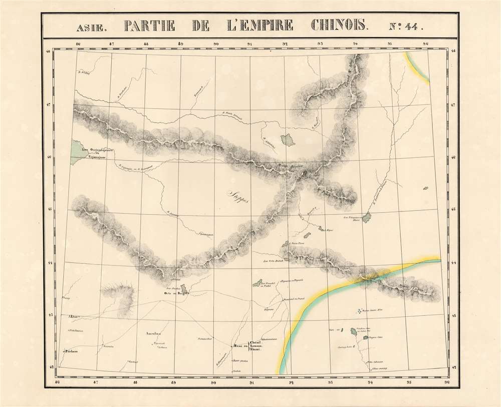
This is Vandermaelen's 1827 map of Xinjiang Provincem, northwestern China, and south-central Mongolia. It is the first map of the region produced by lithography. Xinjiang, even in the nineteenth century, remained for Europeans one of the least-understood parts of the world. The northwest portion of the map shows the upper Irtysh River, near its headwaters on the border with Mongolia. The lake 'Ourjounojounor' may correspond with Lake Balkhash, Kazakhstan. Further to the south, Lake Barköl, now part of the Barköl Kazak Autonomous County, Kumul Prefecture is shown. A number of settlements are named in the southern portion of the map, which for the most part details the western Gobi. Of these settlements, the most recognizable is Hami, an ancient city known for its delicious melons.
Publication History
This map appeared in the second part, Asie, of Vandermaelen's Atlas universel de géographie physique, politique, statistique et minéralogique. The atlas was produced in one edition in 1827; only 810 complete sets were sold. The full set of six volumes appears in eleven institutional collections in OCLC; the 6th volume alone is listed in about thirteen. This separate map is not cataloged in OCLC.
Cartographer
Philippe Marie Guillaume Vandermaelen (December 23, 1795 - May 29, 1869) was a Flemish cartographer active in Brussels during the first part of the 19th century. Vandermaelen is created with "one of the most remarkable developments of private enterprise in cartography," namely his remarkable six volume Atlas Universel de Geographie. Vandermaelen was born in Brussels in 1795 and trained as a globe maker. It was no doubt his training as a globe maker that led him see the need for an atlas rendered on a universal scale in order that all bodies could be understood in relation to one another. In addition to his great work Vandermaelen also produced a number of globes, lesser maps, a highly detailed 250 sheet map of Belgium, and several regional atlases. More by this mapmaker...
Source
Vandeermaelen, P., Atlas universel de geographie physique, politique, statistique et mineralogique, (Bruxelles: Vandermaelen) 1827.
Atlas Universel de Geographie. This great work, featuring some 378 unique maps and compiled over three years, was the first lithograph atlas, and the first to render the world on the same projection and at a uniform scale. It was no doubt Vandermaelen’s training a globe maker that led him see the need for an atlas rendered uniformly so that all bodies could be understood in relation to one another. As a result, many newly emerging areas received more attention than prior efforts. Maps of the American West, in particular, benefited: ‘no mapmaker had previously attempted to use such a large scale for any western American area.’ (Wheat). Central and South Asia also appear in sharper focus. Despite Vandermaelen’s reliance upon existing sources, his maps very frequently provided the clearest depictions available of many poorly-understood parts of the world. The atlas was an expensive production, costing $800 in 1827. Subscription lists indicate that only 810 full sets of the atlas were sold. It was printed on high-quality paper with superior hand coloring and was engraved in a clear, legible style. Conjoined, the maps of Vendermaelen's atlas would create a massive globe some 7.75 meters in diameter, a feat which was accomplished at the Etablissement Geographique de Brussels.
Very good.