|
||

|

|
|

|
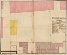
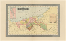
Engaging plan of Toluca, México on the eve of Independence
This is a brightly-colored draft, a borrador, of a plan of the city of Toluca, now in the state of México in central México. It shows the meticulous town planning of the Spanish colonial city, as well as the details of a growing populous.
The plan shows the town's grid pattern, a legacy of Spanish colonialism. The central square, or zocalo, is in the northwest of the town, abutting the river that cuts through the city. Facing the central square is the monastery of San Francisco and cantinas (south side), government offices and the jail (west side), and various warehouses and businesses. Leading north of the square are the two main bridges across the river. Other notable buildings, all of which are listed in the key in the lower right corner, include a hospital, military quarters, various churches and chapels, a post office, and a sports pitch (#20 in the east of the town). The city is surrounded by milpas, or corn fields and, to the north, the hills begin to rise.
The plan may have been ordered by the Crown to monitor the growing city, but a note in the explanation tells us that a portion of the city, demarcated with a grey line on the city's main thoroughfare, remained to be accounted for. Thus, the plan may have been part of a review of land and building ownership for tax purposes.
As stated in the title at the top, this plan was taken by Don José Mariano Dominguez de Mendoza, a lieutenant in the Royal Corps of Engineers. Spain had been reforming its army engineering corps since the beginning of the eighteenth century, when Jorge Verboom, a Belgian, came to Spain to create courses in Artillery and Engineering. In 1711 Spain opened its first School of Engineering. In the early 1800s, Diego García Conde began to develop engineering within the colonial Mexican troops and in 1818, just one year after this plan was made, he established the Technical Corps of Engineers in the Viceregal Army. He continued to work to develop engineering training in the nascent Mexican state.
This plan, however, was made by a surveyor in the employ of the Spanish Army. Dominguez de Mendoza was active throughout the end of the colonial period as a surveyor and his works include a plan of the village of Guadalupe, now held in the Real Academic de la Historia in Spain.
It is appropriate that Dominguez de Mendoza marked the corn fields surrounding the city as its original name, given by the Matlatzincas, was Nepintahihui, land of corn. Toluca is derived from the Nahuatl name given by the Aztecs. It refers to the god Tolo.
The Valley of Toluca has been settled for thousands of years. Just north of the present city are the ruins of a city, Calixtlahuaca, which served as a capital for a local ruling group. The Mexica emperor Axayacatl conquered the valley in 1478, making the area a tributary state. Prior to the coming of the Mexica, Tollocan, as it was known then, was a small city-state. Axayacatl elevated the city's importance and destroyed Calixtlahuaca.
The Spanish invaded the valley in 1521. Later, the area was part of the huge land concession given to Hernán Cortés by Charles V. By 1524 conversion of the local indigenous population was underway. This process was not always coercive, however, and Father Andrés Castro learned the Matlatzincan language and seems to have been liked by the local people.
The Spanish began to settle the area in 1530, but Toluca was not considered a town by the Crown until 1677. In 1793, a quarter century prior to this plan, a road to Mexico City began construction, although it is unclear which road this is in the plan. In 1799, the Crown designated Toluca a city.
Located only forty miles from Mexico City, it is no wonder the city became embroiled in the War of Independence. After the Grito de Dolores, Miguel Hidalgo stayed in Toluca en route to the Battle of Monte de las Cruces. A year later, a group of indigenous peoples were shot by royalists, later inspiring the naming a plaza for those who were killed.
In 1812 Toluca had its first city council appointed and these local authorities declared the city independent, along with the nation of Mexico, in 1821. In 1830, Toluca became the constitutional capital of the state of Mexico.
Today, the city is much altered from this humble plan. Toluca and its surroundings metropolitan area is the fifth largest in Mexico, with nearly two million people living there.
“Los Ingenieros Militares en el México Independiente”, http://repositoriodigital.academica.mx/jspui/bitstream/987654321/183867/1/LOS%20INGENIEROS%20MILITARES%20EN%20EL%20MEXICO%20INDEPENDIENTE.pdf
![[Mexico City and Environs] Mapa de las Lagunas, Rios y Lugares que Circundan a Mexico: para mayor inteligencia de la Historia y Conquista de Mexico que escribió Solis . . . 1783](https://storage.googleapis.com/raremaps/img/small/91029.jpg)