Heavy thunderstorms, strong winds pummel DMV area
WASHINGTON - A severe thunderstorm warning put residents on alert in Northern Maryland, parts of Washington D.C., Northern Frederick, and Northern Carroll County Thursday evening.
After a very active 8 p.m. - 9 p.m., which included a possible touchdown of a weak tornado near Tysons Corner, the warnings in place were lifted.
There are a few cells out there to watch though.
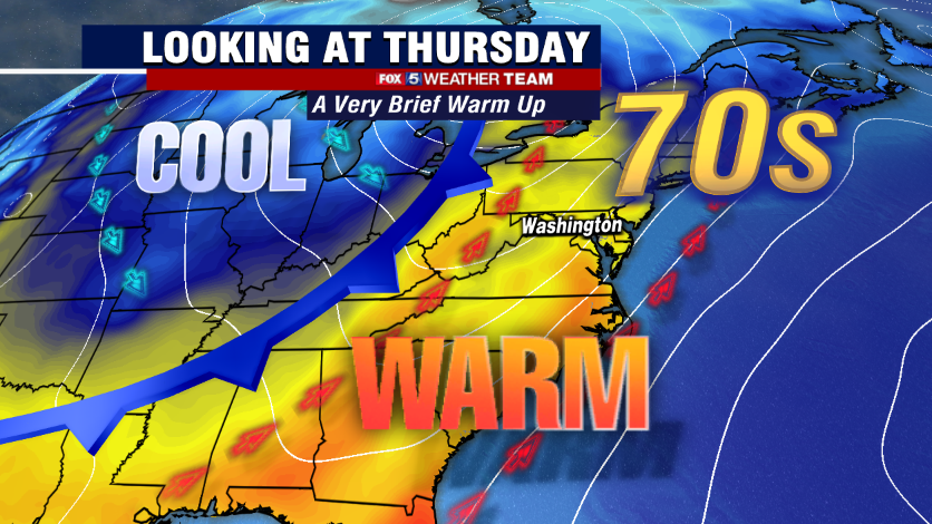
Winter's revenge has come and, thankfully, gone during these last few days of March. The last three days have averaged about fifteen degrees below the seasonal average, with high temperatures more typical of the middle of January than nearly the beginning of April.
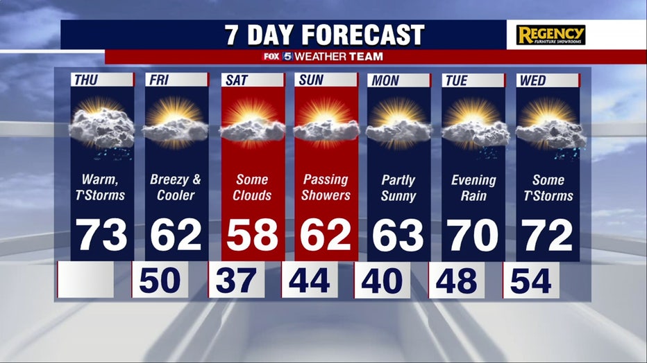
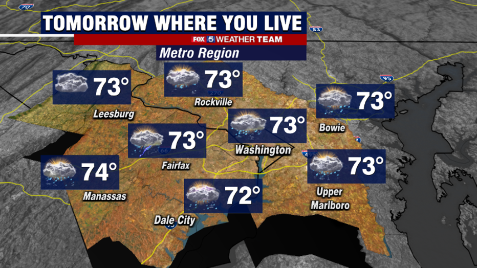
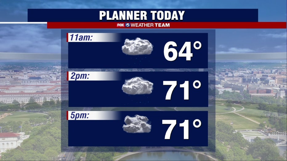
It's been over a week since we've hit the 70s, and we should pretty easily do it on Thursday afternoon.
The problem is that, despite the warmth, Thursday will not be the nicest of days. The morning is likely to start off with some clouds, patchy fog, and even some showers, and the evening is likely to end with potentially some strong to severe thunderstorms.
It is in between, likely during the middle of the afternoon, when skies could break into some peeks of sun just briefly. That could be enough to push our temperatures into the middle 70s.
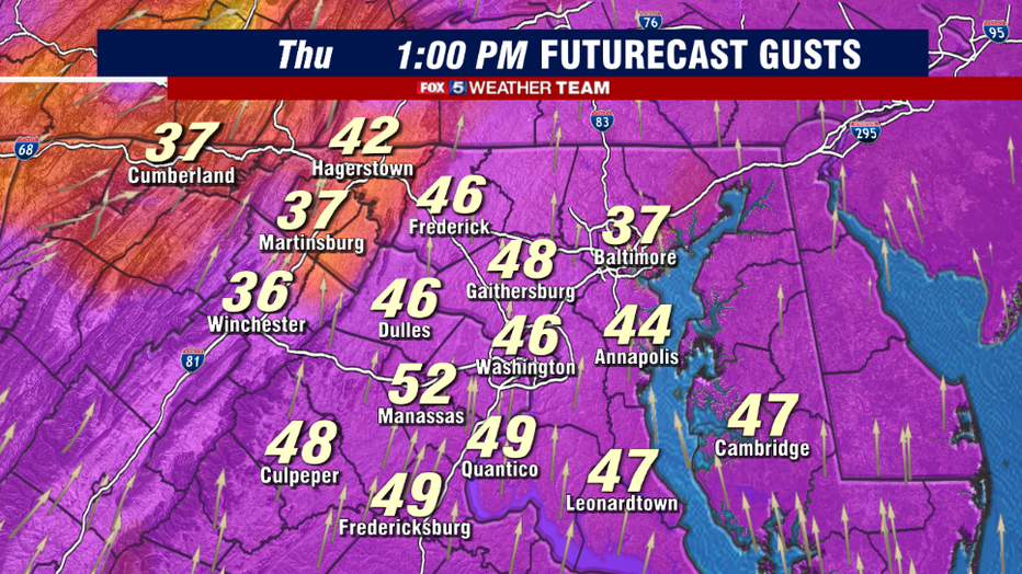
The problem with Thursday's warmth is that, while it will feel good, it won't be a calm warmth. Winds as early as the morning commute will start roaring out of the south at 20-30mph, with afternoon gusts peaking between 30-50mph as warmer air screams into our region.
Winds alone could do some damage and bring down some loose branches or power lines. The National Weather Service is considering a wind advisory for our area tomorrow.
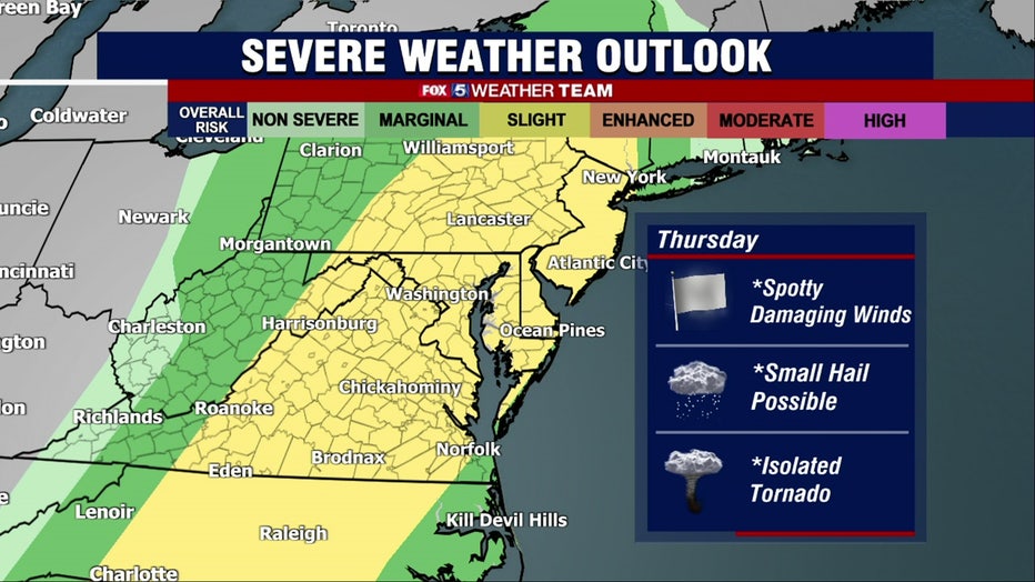
Of course, the big concern with tomorrow will be the potential for some severe thunderstorms. For the last few days, the National Weather Service has highlighted our area for a "slight risk" of severe weather on Thursday afternoon and evening.
A "slight risk" means some severe thunderstorms are expected, but it is not expected to be a widespread outbreak. This is the same system that is producing widespread tornado watches and warnings across much of the southern United States today.
Thankfully, the energy will weaken as the storm system approaches our region, but there will still be enough that we cannot rule out some thunderstorms with damaging wind gusts, hail, and the isolated threat of a tornado.
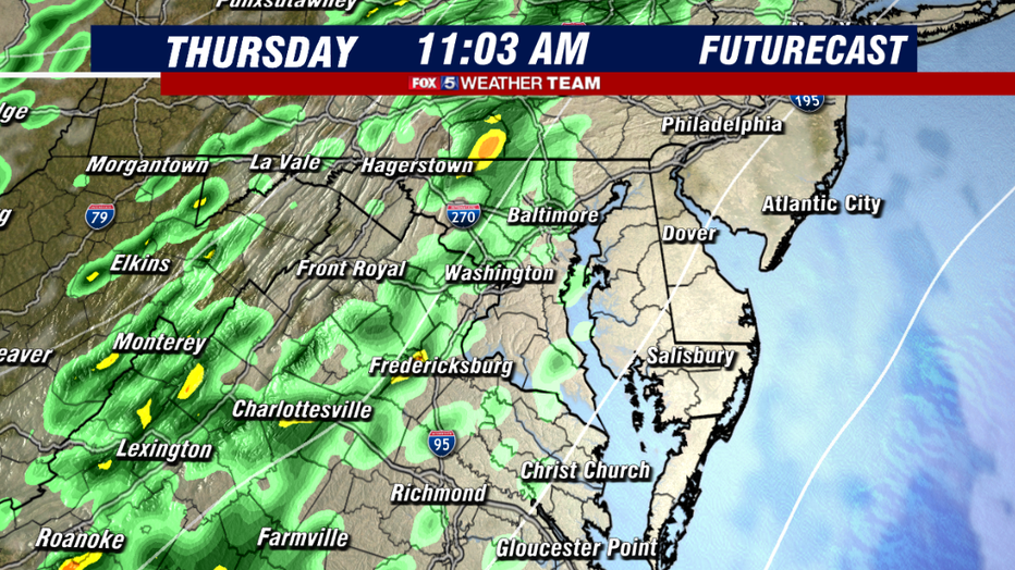
The system first starts to impact us in the morning. Aside from the warm temperatures, the strong wind will also be streaming in ample moisture to our region.
Drizzle will be possible as early as the morning commute, with scattered showers more likely as we get closer to the late morning hours. While temperatures will be warmer, it will not be a very nice-looking start to Thursday.
By the early afternoon hours, showers may continue for the eastern parts of our area. Southern Maryland, the Northern Neck, and the Eastern Shore could all see on and off showers continue well into the daytime hours.
Between the I-81 and the I-95 corridors, a period of dry weather should push in, and some sunshine mixing in should allow temperatures to quickly jump into the 70s. This period will be key to the threat of storms late. If we stay showery or cloudy, and therefore cooler, than expected, it would limit the severity of the thunderstorm risk during the afternoon.
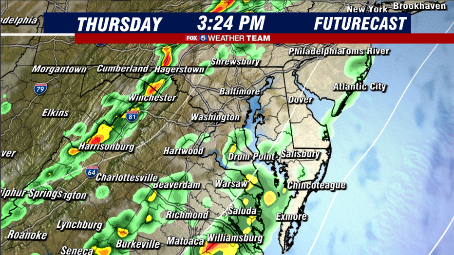
So we will be keeping a very close eye on this time window. Assuming we do break out into some sun and head up, a line of thunderstorms could begin to develop by the middle afternoon across the mountains and highlands to the west. Winchester, Hagerstown, Harrisonburg, and others could all see storms rumbling through as we approach the 4 p.m. hour.
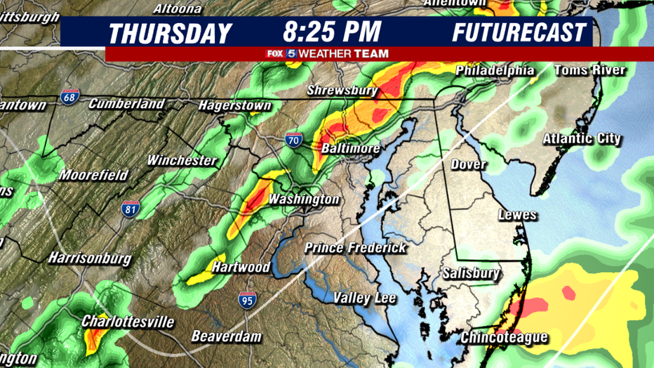
As we get closer to and just beyond the evening commute hours, that is where things become more concerning around the immediate D.C. area, Northern Virginia, and Central Maryland.
Computer guidance today has indicated the threat for some of these storms to develop what we call "bowing line segments," which is where thunderstorms take on a look similar to a bow that one would see in an archery competition. This is an indication that damaging winds will be possible, and that is the primary thing we are concerned with when it comes to storms Thursday.
As far as tornadoes are concerned, you can never rule them out completely especially not when the storm system itself has a history of producing them, however, the wind field overhead suggests that any tornado threat should be very limited.
The weather team will be here tracking just in case one should fire, and will keep you up to date on all the threats through tomorrow night.
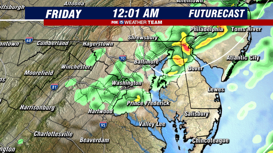
The threat of storms should remain in the forecast up through about the midnight hour when a cold front will finally cross our region from west to east. Any severe threat should diminish as the winds shift, and nighttime cooling takes over, but showers could linger into the predawn hours of Friday, especially for our eastern zones.
Skies should then slowly clear as drier air pauses into our region into Friday morning. Sunrise hours on Friday should be drier but will feel cooler as temperatures fall back into the 40s and 50s.
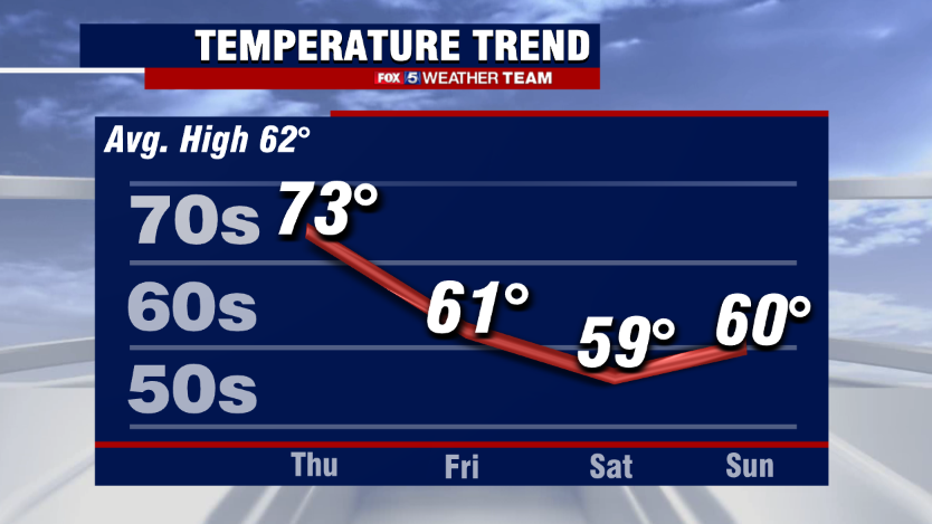
As we enter the month of April, temperatures will dip back to seasonally cool levels, with mostly 50s and lower 60s through the weekend. All indications are that we will go back and forth between seasonally cool, and warm temperatures through the first half of April.
This is actually not too uncommon during the early spring months, especially in active storm patterns. Storms go up through the middle of the country, upwell warmth through our region, then after they pass us wrap around some cooler temperatures.
Thankfully, from a forecaster's perspective, we do not see temperatures nearly as cold as what we just experienced these past few days for the foreseeable future.