Data and credits
Explanatory notes:
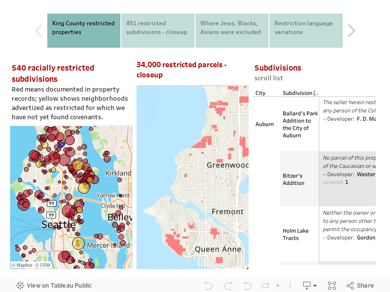
These are preliminary findings and our research is far from complete. On the 30,000 parcel map, we have color-coded the parcel dots to indicate levels of data certainty. Those shown in red are confirmed in documents we have found. Those in yellow are suspected because we have found newspaper advertising claiming that these neighborhoods were "restricted," but have not yet found full documentation. Those shown in green are subject to the Sanborn rule. In the 1925 Sanborn V. McLean case, the Michigan Supreme Court ruled that restrictions could apply even if not mentioned in a deed of sale provided the developer had routinely imposed them in earlier sales. Courts in other states followed this rule of "implied covenants" which usually meant that an entire subdivision was covered by a restriction imposed by the original developer. In these maps, green dots indicate that we have found enough documents to assume that the covenant covered the rest of the subdivision.
On the map above, do not assume that areas without circles were not restricted. We have not yet searched tens of thousands of relevant property records and expect to find many more restricted neighborhoods. Moreover, restrictive covenants were only one of the mechanisms of segregation. Neighborhoods without covenants often practiced racial exclusion by other means.
There is a logic to the geography. Areas platted (subdivided) between 1925 and 1948 were most likely to be restricted. Realtors and developers wrote racial exclusions into the initial documents subdividing a future neighborhood. All properties in the subdivision were thus legally restricted. That is how so many north Seattle, south Seattle, and suburban tracts came to be restricted. It was more complicated to restrict older areas. Neighborhood associations organized petition drives and convinced white homeowners to add racial restriction clauses to their properties in Capitol Hill, Madison Park, Queen Anne, Magnolia, and parts of Madronna. Look at the language of restriction in these deeds. Some specify that neighborhoods are reserved for "Whites," while others enumerate the prohibited racial groups. And the wording is curious. In the terminology of the 1920s-1940s "Hebrews" meant Jews; "Ethiopians" meant African ancestry; "Malays" meant Filipinos; "Mongolians" meant all east Asians; "Hindus" meant all south Asians. Most shocking is the "Aryans only" restriction imposed on a subdivision in Clyde Hill. That racial concept, favored by Adolph Hitler, was written into deeds as late as 1948.
Credits: The database is incomplete. The work of locating restricted property records started in 2005. Two teams of UW students began the project. Carolyn Lind was the first section coordinator and personally located almost half of the initial restrictions. In Spring 2005, she was joined by Karen Oliver, Pauline Chardoul-Sutter, Susan Griffith, Dien Luu, and Doug Marcoux who sampled deeds registered between 1925 and 1935 as a class project for HSTAA 353. In Spring 2006, BreeAnn Larios, Marco Vargas, Rebecca Gray, Tracie Newbins, Amber Price, Nichole Murray, and Jonathan Brooks collected restrictions that had been registered between 1941 and 1948. More recently, Greg Lange, archivist at the King County Archives, has located dozens of additional covenants and Amanda Miller and Katherine Cavanaugh found others. In 2022, King County Archives allowed access to digital records for the period 1910-1930. That research was coordinated by Jazzlyn Woods, Sophia Dowling, Samantha Cutts, and Erin Miller. Currently we are in the process of scanning records for the years 1931-1955 and will be adding to the maps and database in coming months.