The Tana Delta and Forests Complex: A Marvelous Lifeline
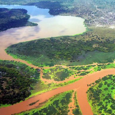
Image credit: Ramsar
When Tana River, Kenya’s longest and widest river system, embarks on its journey downstream from the snowy tops of Mount Kenya and the Aberdare Ranges, one can almost say it is in pursuit of a grander destiny. As it nears its imminent end, riparian forests begin to grow along its meandering banks, and just before it clocks its record length of 1,000 kilometres and empties into the Indian Ocean, it slows and splits in preparation to meet the coastline, resulting in a magnificent wetland that spreads over 30km – The Tana Delta.
In totality, the Tana Delta and the surrounding wetland areas make up about 1636 square kilometres and was officially established in October 2012 as Kenya’s sixth Ramsar Site – a wetland designated to be of international importance – and the only one outside Rift Valley.
An Outstanding Ecosystem
The Tana riparian forests, namely, Boni, Dondori, Lunghi, Lower Tana, and Lango ya Samba Witu, together with the Tana Delta, form an ecosystem like no other at the coast, made up of estuaries, oxbow lakes, floodplain grasslands, woodlands, mangroves, beaches, and even dunes.
With this combination of freshwater, marine, and coastal ecosystems, the Lower Tana biosphere is home to a unique set of plants and animals. The forests host at least 61 plant species that are nationally or globally rare and are the only home to two primates: Tana River Red Colobus and Tana Mangabey.
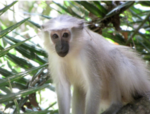
Tana River Mangabey. Image credit: Palm Oil Detectives

Tana River Red Colobus Monkey. Image credit: Twiga Tours
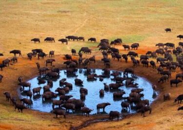
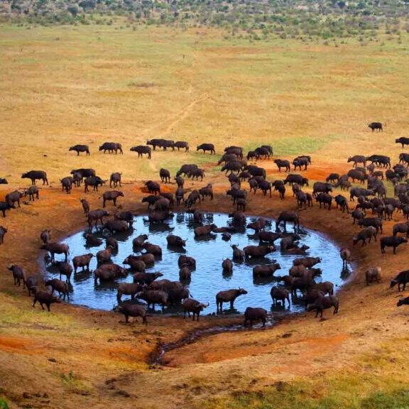
The river and delta, on the other hand, boast a habitat for over 22 freshwater fish species alongside hippos, turtles, crocodiles, and sturdy mangrove forests that are breeding grounds for fishes and crustaceans. At the crescendo of Tana’s journey, where the coastline meets the wetland and offshore islets, aquatic bird folk gather to cheer the river on as it takes on a new form.
Degrading Human Activities
Despite its majesty and persistence across varying landscapes, Tana River is in constant conflict with the communities it engages with on its journey. Its riverine forests, which are home to the Pokomo community, have experienced a great deal of overexploitation for wood fuel, timber, and traditional medicine. As the community’s population grows, more and more people encroach into the forests, felling trees and clearing to pave the way for agricultural farmlands. Woodlands and mangrove forests have also been destroyed, and even wildlife hunted threateningly.
The delta, on the other hand, hasn’t been spared from these detrimental human activities. In pursuit of arable land, some people have taken to farming on Tana’s banks, turning their backs on the delicate nature of the riverside. In two of the river’s major distributaries, rice farmers have built barrages to redirect water to their irrigation farms, which has significantly lowered the volume of water in the river and, in the past, led to the river changing its course a couple of times.
This is exacerbated by the fact that the river’s flow has been heavily impacted upstream by the Seven Forks Scheme Dams used for hydroelectric generation, which has affected its flood regime, threatening the survival of the edaphic riverine forests along Tana.
A Need for Restoration
Tana’s long journey from the mountain tops to the Indian Ocean is a labour of sustenance. Its determination to change course amid disturbance reflects a fighting spirit for the biodiversity that reigns along its banks and is a clarion call for it to be protected for the benefit of both man and wildlife.
For its magnificence, resilience, and power, Tana River, its delta and forest complexes are iconic. Sitting on the UNESCO World Heritage’s tentative list is the Tana glory, waiting to be unleashed with proper management so that it can sing harmony and breathe life every step of its way.


2 Comments
This is a good description. However, it could be improved. One , the length of the river is 1,000 kilometres NOT “square kilometres “. Two, the dam is Seven FORKS dam not FOLKS.
On a different issue is the need to emphasise how the Thika River meets Chania River at Blue Posts Hotel and, now together, they meander through lower Murang’a county to join its partner Sagana River from Mt Kenya as they find their way to the Indian Ocean .
A truly formidable union…..
Thank you so much for enriching the story. Truly appreciate!